
Mayiladuthurai is a town and district headquarter of Mayiladuthurai district in Tamil Nadu, India. The town is located at a distance of 281 km (175 mi) from the state capital, Chennai.

Mannargudi is a town in Thiruvarur district in the Indian state of Tamil Nadu. It is the headquarters of the Mannargudi taluk. The town is located at a distance of 28 km (17 mi) from the district headquarters Thiruvarur, 36 km from Kumbakonam, 40 km from Thanjavur and 310 km (190 mi) from the state capital Chennai. Mannargudi is known for the Rajagopalaswamy temple, a prominent Vaishnavite shrine.

Velankanni (Vēḷāṅkaṇṇi), is a Special Grade Panchayat Town in Nagapattinam district in the Indian state of Tamil Nadu. It lies on the Coromandel Coast of the Bay of Bengal, 350 km south of Chennai (Madras), 12 km south of Nagapattinam, and 33 km southeast of Thiruvarur.

Thiruvarur also spelt as Tiruvarur is a town and municipality in the Indian state of Tamil Nadu. It is the administrative headquarters of Thiruvarur district and Thiruvarur taluk. The temple chariot of the Thyagaraja temple, weighing 360 tonnes (790,000 lb) and measuring 96 feet (29 m) tall is the largest temple chariot in India. Thiruvarur is the birthplace of Tyagaraja, Muthuswami Dikshitar and Syama Sastri, popularly known as the Trinity of Carnatic music of the 18th century CE. Thiruvarur Thiyagarajaa Swaamy temple is older than Tanjore big temple.
Madukkur is a Town Panchayat in Thanjavur District, Tamil Nadu, India. The town is located at middle east part of Tamil Nadu. It has 34 Union panchayat villages in rural. Being the Cauvery River Delta inhabitants.

Muthupettai (முத்துப்பேட்டை) is a town in the Thiruvarur district in the Indian state of Tamil Nadu. It is also known as Pearlpet. Muthupet comes under the Thiruthuraipoondi assembly constituency which elects a member to the Tamil Nadu Legislative Assembly every five years. The current member of the legislative assembly (MLA) is Marimuthu of the Communist Party of India, a part of the Nagapattinam, which elects its member of parliament (MP) every five years. The Muthupet city in-town panchayat was constituted in 1962. The town comes under the administrative territory of the Thiruvarur District. It extends over an area of 12.80 km2.

Needamangalam (Nidamangalam) formerly Yamunambalpuram, is a town panchayat in Thiruvarur district in the Cauvery Delta of Indian state of Tamil Nadu. Needamangalam was originally part of composite Tanjore District during British Raj until 1997 AD. In the 18th and 19th century, it was also called Yamunambalpuram. Needamangalam is the headquarters of the Needamangalam Taluk. The town is located 20 km east of Thanjavur, 80 km east of Tiruchirappalli and 318 km south of Chennai. Needamangalam is a junction for two busy highways, (i) National Highway 67 is a National Highway in Southern Indian states of Tamil Nadu and Karnataka that runs from Nagapattinam, a sea-side town in Tamil Nadu to Gundlupet, Karnataka (ii) State Highway SH-66 connecting Kumbakonam with Adirampattinam via Mannargudi in Cauvery Delta.

Pattukkottai is a major town in Thanjavur district in the Indian state of Tamil Nadu and also important town in Delta districts and Commercial town of Thanjavur, Thiruvarur and Pudukkottai district Coastal areas. The town came to prominence throughout Southern India after the construction of the fort by Vanaji Pandithar, a feudatory of the Thanjavur Maratha ruler Shahuji I in 1686–87. The recorded history of Pattukkottai is known from the 17th century and has been ruled, at different times, by the Thanjavur Marathas and the British. It is the headquarters of the Pattukkottai taluk of Thanjavur district and is one of the two municipalities in the district.
Thalainayar is a panchayat town in Nagapattinam district in the Indian state of Tamil Nadu. It is near Vedaranyam. It is famous for its Agraharam street, which has a Ram and Siva temple.

Thiruthuraipoondi is a municipality in Tiruvarur district in the Indian state of Tamil Nadu. Thiruthuraipoondi is an agricultural town located south of Thiruvarur district.
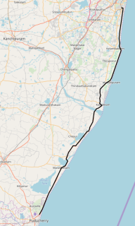
East Coast Road (ECR), combination of SH-49, NH-332A, NH-32, officially known as Mutthamizh Arignar Kalaignar Road, is a two-lane highway in Tamil Nadu, India, built along the coast of the Bay of Bengal connecting Tamil Nadu's state capital city Chennai with Kanyakumari via Puducherry, Cuddalore, Chidambaram, Sirkali, Thirukkadaiyur, Tharangambadi, Karaikal, Nagore, Nagapattinam, Thiruthuraipoondi, Muthupet, Adirampattinam, Manora, Manamelkudi, Mimisal, Ramanathapuram, Thoothukudi, Tiruchendur, Uvari, Kudankulam. The total length of the road is about 777 km between Chennai and Kanyakumari.

Thiruvarur district is one of the 38 districts in the Tamil Nadu state of India. As of 2011, the district had a population of 1,264,277 with a sex-ratio of 1,017 females for every 1,000 males.
Vangathangudi, also known as Vengathangudi, is a village panchayat near Mannargudi, in Thiruvarur District in the Indian state of Tamil Nadu. It has the Vairavanathar temple and a panchayat school.
Adirampattinam is a newly established Municipality in the Pattukottai taluk of the Thanjavur district in the Indian state of Tamil Nadu. It is also short known by Adirai. It is the largest coastal town in the district and fourth largest town in the Thanjavur district.

Thanjavur has a well-developed transport infrastructure. Thanjavur is well connected by Road, and Rail with most cities and towns in India
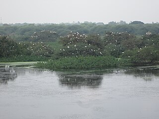
Vaduvoor Bird Sanctuary is a 128.10-hectare area located in Vaduvoor lake, Mannargudi Taluk, Thiruvarur District, Tamil Nadu, India. The sanctuary is about 25 kilometers from Thanjavur and 14 kilometers from Mannargudi on the Thanjavur-Kodiakkarai State Highway 63. It was created in the year 1999. The irrigation tank receives water from November to April every year which attracts numerous foreign birds from Europe and America. The sanctuary attracts more than 40 species of water birds like the white ibis, painted stork, grey pelican, pintails, cormorants, teals, herons, spoonbills, darters, coots, Open bill storks, and pheasant–tailed jacana. The sanctuary is a favorite spot for the migratory birds and during the months of November and December more than 20000 winged visitors reach this area. The sanctuary has basic facilities for tourists to stay overnight and enjoy watching the birds from the two watch towers.

Thiruvarur Junction is a junction railway station serving Thiruvarur town, headquarters of Thiruvarur district in Tamil Nadu in India and a focal point on the branch line connecting trains from Chennai to Nagapattinam–Velankanni–Nagore–Karaikal on one line and Karaikkudi–Sivganga–Manamadurai–Rameswaram on the second line and Tiruchirappalli–Thanjavur–Thiruvarur–Nagapattinam–Karaikal on the third line and Mayiladuthurai–Thiruvarur on the fourth line that branches out of the station.

Tiruturaipundi Junction railway station is a junction railway station serving the town of Thiruthuraipoondi in Tamil Nadu, India.
Pattukkottai railway station is a railway station serving the town of Pattukkottai in Tamil Nadu, India.

Very Severe Cyclonic Storm Gaja was the sixth named cyclone of the 2018 North Indian Ocean cyclone season, after Cyclones Sagar, Mekunu, Daye, Luban, and Titli. Forming on November 5 as a low-pressure system over the Gulf of Thailand, the system crossed through Southern Thailand and the Malay Peninsula and eventually crossed into the Andaman Sea. The weak system intensified into a depression over the Bay of Bengal on November 10 and further intensified to a cyclonic storm on November 11, being named Gaja. After tracking west-southwestward for a number of days in the Bay of Bengal, Gaja made landfall in South India on November 16, moved westward through Vedaranyam, Thiruthuraipoondi,Mannargudi, Muthupet, Pudukkottai, Adirampattinam, Pattukkottai, and Peravurani. The storm survived its crossing into the Arabian Sea; however, it degenerated into a remnant low in hostile conditions only a few days later, before dissipating early on November 22. 45 people were killed by the storm. 8 people were killed in the town of Pattukottai alone. Gaja had severe impacts in South India, particularly in Tamil Nadu. After Cyclone Gaja, Tamil Nadu sought Rs 15,000 crore from Indian central government to rebuild.

