Munnavalkottai

Last updated
Munnavalkottai
Village
Nickname(s): 
MSK
India Tamil Nadu location map.svg
Red pog.svg
Munnavalkottai
Location in Tamil Nadu, India
Coordinates: 10°45′25″N79°22′14″E / 10.756866°N 79.370650°E / 10.756866; 79.370650 Coordinates: 10°45′25″N79°22′14″E / 10.756866°N 79.370650°E / 10.756866; 79.370650
CountryFlag of India.svg  India
State Tamil Nadu
District Thiruvarur
Taluka Needamangalam
Elevation
28 m (92 ft)
Population
(2011)
  Total947
Languages
  Official Tamil
Time zone UTC+5:30 (IST)
PIN
614403
Telephone code04367
Vehicle registration TN-50

Munnavalkottai is a village in the Needamangalam taluk of Thiruvarur district in the Indian state of Tamil Nadu.

Village Small clustered human settlement smaller than a town

A village is a clustered human settlement or community, larger than a hamlet but smaller than a town, with a population ranging from a few hundred to a few thousand. Though villages are often located in rural areas, the term urban village is also applied to certain urban neighborhoods. Villages are normally permanent, with fixed dwellings; however, transient villages can occur. Further, the dwellings of a village are fairly close to one another, not scattered broadly over the landscape, as a dispersed settlement.

Needamangalam Taluk is a taluk in Thiruvarur district of the Indian state of Tamil Nadu. The headquarters of the taluk is the town of Needamangalam.

India Country in South Asia

India, also known as the Republic of India, is a country in South Asia. It is the seventh largest country by area and with more than 1.3 billion people, it is the second most populous country as well as the most populous democracy in the world. Bounded by the Indian Ocean on the south, the Arabian Sea on the southwest, and the Bay of Bengal on the southeast, it shares land borders with Pakistan to the west; China, Nepal, and Bhutan to the northeast; and Bangladesh and Myanmar to the east. In the Indian Ocean, India is in the vicinity of Sri Lanka and the Maldives, while its Andaman and Nicobar Islands share a maritime border with Thailand and Indonesia.

Contents

Geography

Munnavalkottai has an elevation of 28 m (92 ft). It is situated about 7 Kilometers West of Needamangalam, 19 Kilometers North of Mannargudi, 31 Kilometers South of Kumbakonam, 31 Kilometers East of Thanjavur and 36 Kilometers West of Tiruvarur. Munnavalkottai is in the border of the Thiruvarur District and Thanjavur District and has a Branch Post office [1] [2] with Sub Post office in Kovilvenni. Munnavalkottai is surrounded by Koradacherry Taluk towards East , Ammapettai Taluk towards west , Kodavasal Taluk towards North , Mannargudi Taluk towards South.

Mannargudi Place in Tamil Nadu, India

Mannargudi is a town in Tiruvarur district in the South Indian state of Tamil Nadu. It is the headquarters of the Mannargudi taluk. The town is located at a distance of 20 km (12 mi) from the district headquarters Tiruvarur and 310 km (190 mi) from the state capital Chennai. Mannargudi is known for the Rajagopalaswamy temple, a prominent Vaishnavite shrine.

Kumbakonam City in Tamil Nadu, India

Kumbakonam, is a city and a special grade municipality in the Thanjavur district. It is located 40 km (25 mi) from Thanjavur and 273 km (170 mi) from Chennai. Kumbakonam is known as a "temple city" due to the prevalence of a number of temples here and is noted for its Mahamaham festival which attracts people from all over the country.It is the third largest city in central Tamil Nadu and second largest city in Cauvery delta region.It is one of the economic hub of Central Tamil nadu.

Thanjavur City in Tamil Nadu, India

Thanjavur, formerly Tanjore, is a city in the Indian state of Tamil Nadu. Thanjavur is an important center of South Indian religion, art, and architecture. Most of the Great Living Chola Temples, which are UNESCO World Heritage Monuments, are located in and around Thanjavur. The foremost among these, the Brihadeeswara Temple, is located in the centre of the city. Thanjavur is also home to Tanjore painting, a painting style unique to the region.

Demographics

In the 2011 India census, Munnavalkottai had a population of 947. [3] Males constituted 48% of the population and females 52%. Munnavalkottai had an average literacy rate of 72%: male literacy was 79%, and female literacy was 65%. In 2011 in Munnavalkottai, 10% of the population was under 6 years of age.

Census Acquiring and recording information about the members of a given population

A census is the procedure of systematically acquiring and recording information about the members of a given population. The term is used mostly in connection with national population and housing censuses; other common censuses include agriculture, business, and traffic censuses. The United Nations defines the essential features of population and housing censuses as "individual enumeration, universality within a defined territory, simultaneity and defined periodicity", and recommends that population censuses be taken at least every 10 years. United Nations recommendations also cover census topics to be collected, official definitions, classifications and other useful information to co-ordinate international practice.

Schools

Temples

Politics

Munnavalkottai belongs to Mannargudi (State Assembly Constituency) [4] is part of Thanjavur (Lok Sabha constituency).

Thanjavur (Lok Sabha constituency) Lok Sabha Constituency in Tamil Nadu

Thanjavur is a Lok Sabha constituency in Tamil Nadu.

Related Research Articles

Thiruvarur Town in Tamil Nadu, India

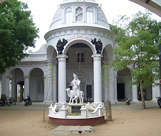
Thiruvarur also spelt as Tiruvarur is a town and municipality in Tiruvarur district in the Indian state of Tamil Nadu. It is the administrative headquarters of Tiruvarur district and Tiruvarur taluk. The town was one of the five traditional capitals of the Chola empire, with one of the emperors of the dynasty, Kulothunga Chola I, having it as his capital. The town is believed to be of significant antiquity and has been ruled, at different times, by the Medieval Cholas, Later Cholas, Later Pandyas, Vijayanagar Empire, Marathas and the British. The town is known for the Thyagaraja temple, and the annual chariot festival held in the month of April. The temple chariot of the Thyagaraja temple, weighing 300 tonnes (660,000 lb) and measuring 90 feet (27 m) tall is the largest temple chariot in Tamil Nadu. Thiruvarur is the birthplace of Tyagaraja, Muthuswami Dikshitar and Syama Sastri, popularly known as the Trinity of Carnatic music of the 18th century CE.

Thoothukudi district District in Tamil Nadu, India

Thoothukudi District, also known as Tuticorin District is a district in Tamil Nadu state in southern India. The district was formed by dividing Tirunelveli district in 1986 and Thoothukudi is the district headquarters. The district is known for pearl cultivation, with an abundance of pearls being found in the seas offshore. It was formerly ruled by one of the oldest kingdoms in India, the Pandyan Dynasty with the port of Korkai through which trade with Rome happened. The archaeological site at Adichanallur holds the remains of the ancient Tamil civilisation. As of 2011, the district had a population of 1,750,176 with a sex-ratio of 1,023 females for every 1,000 males.

Madukkur Town in Tamil Nadu, India

Madukkur is a Panchayat town in Thanjavur District in the Indian state of Tamil Nadu. It is a small town (city) situated in southern part of Tamil Nadu. It is 11 km from Pattukkottai and 15 km from Adirampattinam It is surrounded with number of villages. Being in the Cauvery River Delta Area the inhabitants’ main occupation is agriculture.

Nannilam Place in Tamil Nadu, India

Nannilam is a panchayat town in Thiruvarur District in the Indian state of Tamil Nadu. It is the headquarters town for Nannilam Taluk. The history of the town revolves around Madhuvaneswarar Temple, the major temple in the town.

Thiruthuraipoondi Town in Tamil Nadu, India

Thiruthuraipoondi is a municipality in Thiruvarur district in the Indian state of Tamil Nadu. Thiruthuraipoondi is 330 km south of Chennai, 40 km south of Nagapattinam and 65 km east of Thanjavur. As of 2011, the town had a population of 24,404.

Valangaiman town panchayat in Tamil Nadu, India

Valangaiman is a panchayat town in the Valangaiman taluk of Thiruvarur district in the Indian state of Tamil Nadu. It is the headquarters town for Valangaiman Taluk.

Tiruvarur district District in Tamil Nadu, India

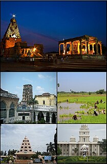
Thiruvarur district is one of the 33 districts in the Tamil Nadu state of India. The district occupies an area of 2161 km². It lies between Nagapattinam district on the east and Thanjavur District on the west, and is bounded by the Palk Strait on the south. The district headquarters is at Thiruvarur town. As of 2011, the district had a population of 1,264,277 with a sex-ratio of 1,017 females for every 1,000 males.

Neivelivadapathy is a village in the Orathanadu taluk of Thanjavur district, Tamil Nadu, India.

Vadaseri South is a village in the Orathanadu taluk of Thanjavur district, Tamil Nadu, India.

Mannargudi taluk is a taluk in Thiruvarur district of the Indian state of Tamil Nadu. The headquarters of the taluk is the town of Mannargudi.

Tiruvarur Taluk is a taluka in Thiruvarur district of the Indian state of Tamil Nadu. The headquarters of the taluk is the town of Tiruvarur.

Elangadu Village in Tamil Nadu, India

Elangadu is a Village in Madukkur Taluk in Thanjavur District of Tamil Nadu State, India. It is located 53 km towards South from District headquarters Thanjavur. 351 km from State capital Chennai.

Nemmeli is an agricultural village in Madukkur Panchayat Union, Pattukkottai taluk of Thanjavur district, Tamil Nadu, India, also known as 28.Nemmeli. Nemmeli village is division of Musugundha Nadu in Chola nadu. It comes under Pattukottai legislative constituency and Tanjore Parliament constituency. It is a small and well developing Village located in southern part of Tamil Nadu. It is 15 km from Pattukkottai and Mannargudi. It is surrounded with number of villages. Being in the Cauvery River Delta Area the inhabitants’ main occupation is agriculture. The younger generation is well educated and they working Various Location in India and also in foreign countries like Singapore, Malaysia, UAE, Saudi Arabia, UK and USA. Many people's working in foreign countries Like Saudi Arabia, Singapore, UK, USA, etc. The economy is booming in line with India’s rapid economic development.

Nidamangalam Junction railway station

Nidamangalam Junction railway station is a Junction railway station serving Needamangalam in Tamil Nadu, India.

Athikkadai Village in Tamil Nadu, India

Athikkadai is a ever green village located in Tiruvarur district - Koothanallur taluk, Tamil nadu, South India. It is located near Mannargudi (south), Kumbakonam (north), Thiruvarur (east) and Thanjavur (west).

Varagur Gram Panchayat in :Tamil Nadu, :India

Varagur is a village in Senthamangalam Taluk, Namakkal district of Tamil Nadu state. Erumaipatti is 7 kilometers and Thathaiyangarpet is 9 kilometers away from the village.

Kalathur Village in Tamil Nadu, India

Kalathur is a panchayat village in Peravurani panchayat Union of Thanjavur district in the Indian state of Tamil Nadu. Kalathur is a part of the Pattukkottai taluk of Thanjavur district and located 67 kilometres (42 mi) south of Thanjavur connected via State Highway 29.

References

  1. "Indian Post Office: Munnavalkottai".
  2. "Post Office Details: Munnavalkottai".
  3. "Census 2011 Population Finder: Tamil Nadu: Thiruvarur: Munnaval Kottai". Office of The Registrar General & Census Commissioner, Ministry of Home Affairs, Government of India.
  4. 1 2 "Elections Booth: Govt High School: Munnavalkottai" (PDF).
  5. "Dinamalar Temples list in Thanjavur Dt".