Shikaripura is a prominent town and the administrative headquarters of Shikaripur Taluk in the Shivamogga District of the Indian state of Karnataka. Located at the transition point between the flat plains (Bayaluseeme) and the hilly Malenadu region.[1]
The name Shikaripura is a blend of the Kannada words "Shikari" (hunter) and "Pura" (town), suggesting its historical use as a regional hunting centre.[2]
Geography
Shikaripur is located at 14°16′N75°21′E / 14.27°N 75.35°E / 14.27; 75.35.[3] It has an average elevation of 603m (1978ft). It lies on tropical forests of Malenadu region. Shikaripura is one of the junction to connect north karnataka to Malenadu. And the river kumadvati flows from the town and nearest dams anjanapura and ambligola, nearest tourist places balligavi, udutadi, jogfalls, lionsafori, agumbe, koodachadri, kavaledurga fort, bhadra river project, gajnur dam, sakrebaylu.
History and Culture
The Shikaripur region is historically significant, having been under the rule of major South Indian powers including the Vijayanagar Empire and Keladi Nayakas. It is particularly noted as the birthplace of the 12th-century Lingayat saint and social reformer Akkamahadevi in the nearby village of Udutadi.[4]
Demographics
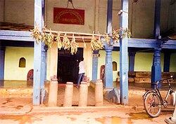
The Huccharaya Swamy temple in Shikaripura
As of 2001[update] India census,[5] Shikaripura had a population of 31,508. Males constituted 51% of the population and females 49%. Shikaripura had an average literacy rate of 71%, higher than the national average of 59.5%: male literacy was 75%, and female literacy was 67%. In Shikarpur, 12% of the population were under 6 years of age.
Places of Interest
Shikaripura is rich in historical and architectural heritage, primarily centered around its ancient temples and historical sites, In the 12th century It is historically associated with eminent Lingayats saints, including Allama Prabhu and Akka Mahadevi .
Balligavi: Located approximately 21 kilometers from Shikaripura town, Balligavi (ancient names include Baligrama and Dakshina Kedara) was a significant capital and center of learning during the Kalyani Chalukya period [6].
Kedareshvara Temple: An example of Late Chalukyan architecture, this trikuta (triple shrine) structure is built of soapstone and stands as a protected monument under the Archaeological Survey of India (ASI) [7][8].
Tripurantakeshwara Temple: Constructed around c. 1070 \text{CE} by the Western Chalukyas, this temple is noted for its sculptural beauty and intricately carved perforated windows and erotic sculptures [9][10]}.
Someshwara Temple: Located in Balligavi, this 13th-century temple is another notable architectural attraction in the region [11].
Udutadi: A village near Shikaripura, Udutadi is recognized as the birthplace of the 12th-century Lingayat saint and social reformer Akkamahadevi [12].
Bandalike: Situated 35 kilometers north of Shikaripura, Bandalike features the Nagarakere tank, a Jain basadi (temple) from the Vijayanagara era, and a Trikutachala temple [13].
Talagunda: This village is historically significant due to the discovery of the Talagunda pillar Sanskrit Inscription of Kadamba crown prince Santivarma (450 CE), collected by the Archaeological Survey of India[14]
Transport
Shikaripura's transport system is primarily reliant on road networks, with a significant railway project currently underway.
Roadways
The town is connected to key cities and districts in Karnataka through major highways.
National Highway: NH 766C passes through Shikaripura, linking Baindur on the coast to Ranebennuru [15].
State Highways: The town is a major point on State Highway 1 (SH 1) and State Highway 57 (SH 57)[16].
Bus Services KSRTC Depot: Shikaripura has its own bus depot operated by the Karnataka State Road Transport Corporation (KSRTC)[17].[18].
Proposed Railway Line
Shivamogga–Shikaripura–Ranebennur Line: The Shivamogga–Shikaripura–Ranebennur New Broad Gauge Railway Line Project (approximately 103 km) is sanctioned as a cost-sharing venture with the Government of Karnataka [19]}.
Status: The first phase of construction for the Shivamogga to Shikaripura section is currently being executed[20].
Proposed Shikaripur District: Political Dynamics
Proposed Shikaripur district
The movement to elevate Shikaripur to a district headquarters has been a major administrative and political issue in Shivamogga district.
Political Advocacy by B.S. Yediyurappa
The proposal is closely associated with former Chief Minister B. S. Yediyurappa, a dominant leader and long-time MLA for the Shikaripur constituency, who first publicly mooted the idea of a separate district in 2008.[21]
In November 2019, the Shikaripur Taluk Panchayat passed a **unanimous resolution** demanding the formation of a new district, arguing that the town possesses the necessary **infrastructure**, including upgraded hospital and administrative buildings, and is strategically positioned to benefit from the proposed Shivamogga-Shikaripur-Ranebennur railway line.[22] The proposed taluks for the new Shikaripur district are:
Shikaripur (from Shivamogga District)
Sagara (from Shivamogga District)
Soraba (from Shivamogga District)
Nyamathi (from Davanagere District)
Honnali (from Davanagere District)
Sagara Counter-Proposal
The inclusion of Sagara in the Shikaripur proposal faces strong resistance from activists in Sagara itself. Organizations like the Sagara Zilla Horata Samiti are actively lobbying for Sagara to be declared the new district centre instead. Their arguments are based on the following key points: Sagara already functions as a Subdivision Headquarters (Assistant Commissioner Office) for the surrounding taluks, including Shikaripur, Soraba, and Hosanagara, giving it a higher existing administrative status than Shikaripur.[23][24], Sagara is a comparatively larger town than Shikaripur. The 2011 Census recorded Sagara's municipal population at 54,550, significantly higher than Shikaripur's town population of 36,015.[25][26]
↑ Karnataka: Proposal for separate Shikaripur district mooted again - Times of India. (2019, November 15). Retrieved from [Source URL for timesofindia.indiatimes.com/city/mysuru/proposal-for-separate-shikaripur-district-mooted-again/articleshow/72061290.cms]
↑ Shikaripur TP demands formation of new district - The Hindu. (2019, November 14). Retrieved from [Source URL for thehindu.com/news/national/karnataka/shikaripur-tp-demands-formation-of-new-district/article29975100.ece]
↑ Police Department | District Shivamogga. (n.d.). Retrieved from [Source URL for shivamogga.nic.in/en/police-department/]
↑ Administration in Shimoga. (n.d.). Retrieved from [Source URL for shivamoggaonline.in/guide/administration-in-shimoga]
↑ Sagar City Municipal Council City Population Census 2011-2025. (n.d.). Retrieved from [Source URL for census2011.co.in/data/town/803131-sagar-karnataka.html]
↑ Shikarpur Town Municipal Council City Population Census 2011-2025. (n.d.). Retrieved from [Source URL for census2011.co.in/data/town/803134-shikarpur-karnataka.html]
External links
Wikimedia Commons has media related to Shikaripur.
This page is based on this Wikipedia article Text is available under the CC BY-SA 4.0 license; additional terms may apply. Images, videos and audio are available under their respective licenses.