List of major rivers of India

Last updated

The rivers in India play an important role in the lives of its people. They provide potable water, cheap transportation, electricity, and the livelihood for many people nationwide. This easily explains why nearly all the major cities of India are located by the banks of rivers. The rivers also have an important role in Hindu Religion and are considered holy by many Hindus in the country. [1]

Contents

Seven major rivers along with their numerous tributaries make up the river system of India. The largest basin system pours its waters into the Bay of Bengal; however, some of the rivers whose courses take them through the western part of the country and towards the east of the state of Himachal Pradesh empty into the Arabian Sea. Parts of Ladakh, northern parts of the Aravalli range and the arid parts of the Thar Desert have inland drainage.

All major rivers of India originate from one of the following main watersheds:

  1. Aravalli range
  2. Eastern Ghats ranges
  3. Himalaya and Karakoram ranges
  4. Western Ghats ranges
  5. Vindhya and Satpura ranges and Chotanagpur plateau in central India

eastern Himalayan glaciers in the Indian subcontinent are broadly divided into three river basins, namely the Indus, Ganges and Brahmaputra. The Indus basin has the largest number of glaciers (3500), whereas the Ganges and Brahmaputra basins contain about 1000 and 660 glaciers, respectively. [2] The Ganges is the largest river system in India. However, these rivers are just three among many. Other examples are Narmada, Tapathi, and Godavari.

The Indo-Gangetic plains

The Indo gangetic plains are known as Ganga-Satluj Ka Maidaan (गँगा सतलुज का मैदान), this area is drained by 16 major rivers. The major Himalayan Rivers are the Indus, Ganges, and Brahmaputra. These rivers are long, and are joined by many large and important tributaries. Himalayan rivers have long courses from their source to sea (in India Arabian sea and Bay of Bengal).

Laxman Jhoola in Rishikesh Ganga at Rishikesh.jpg
Laxman Jhoola in Rishikesh

Aravalli Range River System

Following rivers flow from the Aravalli range, both northwards to Yamuna as well as southwards to Arabian Sea.

Ganges River System

The major rivers in this system are (in order of merging, from west to east)

Before entering Bangladesh, near Farakka in Malda District, Ganga leaves a distributary Hoogly, 450 kilometres (280 mi) which provides water for irrigation in West Bengal

Brahmaputra River System

Brahmaputra River basin across Northeast India Brahmaputra-river-basin.png

The Brahmaputra river originates / starts from Tibet.

Indus River System

The Indus River originates in the northern slopes of the Kailash range near Lake Manasarovar in Tibet. Although most of the river's course runs through neighbouring Pakistan, as per as regulation of Indus water treaty of 1960, India can use only 20 percent of the water in this river. A portion of it does run through Indian territory, as do parts of the course. The rivers forming Panjnad are Chenab, Satluj, Jhelum, Ravi and Beas These tributaries are the source of the name of the Punjab of South Asia; the name is derived from the panch ("five") and aab ("water"), hence the combination of the words (Punjab) means "land with the water of five rivers". The Indus is 3,610 kilometres (2,240 mi) long.

The major rivers in Indus river system are (in order of their length):

Annual flows and other data

India experiences an average precipitation of 1,170 millimetres (46 in) per year, or about 4,000 cubic kilometres (960 cu mi) of rains annually. [9] Some 80 percent of its area experiences rains of 50 inches (1,300 mm) or more a year. However, this rain is not uniform in time or geography. Most of the rains occur during its monsoon seasons (June to September), with the northeast and north receiving far more rains than India's west and south. Other than rains, the melting of snow year round over the Himalayas feeds the northern rivers to varying degrees. The southern rivers, however experience more flow variability over the year. For the Himalayan basin, this leads to flooding in some months and water scarcity in others. Despite extensive river system, safe clean drinking water as well as irrigation water supplies for sustainable agriculture are in shortage across India, in part because it has, as yet, harnessed a small fraction of its available and recoverable surface water resource. [10] India harnessed 761 cubic kilometres (183 cu mi) (20 percent) of its water resources in 2010, part of which came from unsustainable use of groundwater. Of the water it withdrew from its rivers and groundwater wells, India dedicated about 688 cubic kilometres (165 cu mi) to irrigation, 56 cubic kilometres (13 cu mi) to municipal and drinking water applications and 17 cubic kilometres (4.1 cu mi) to industry. [9]

According to 2011 report of the Food and Agriculture Organization of the United Nations, India's basin wise distribution of catchment area and utilizable surface water resources is presented in the following table: [9]

Basin numberRiver basin unitRegionDraining intoCatchment area
(% of river
irrigated India)
Average
runoff
(km3)
Additional available
surface water
(km3)
1.1Ganges (GBM)NorthFlag of Bangladesh.svg  Bangladesh 26.5525.02250
1.2Brahmaputra (GBM)NortheastFlag of Bangladesh.svg  Bangladesh 6537.2424
1.3Meghna/Barak (GBM)EastFlag of Bangladesh.svg  Bangladesh 1.548.36
2Other Northeast riversNortheastFlag of Myanmar.svg  Myanmar,
Flag of Bangladesh.svg  Bangladesh
1.131
3SubernarekhaEast-southeast Bay of Bengal 0.912.37
4Brahmani-BaitaraniEast-southeastBay of Bengal1.628.486.8
5MahanadiCentral-eastBay of Bengal4.466.8818.3
6GodavariCentralBay of Bengal9.7110.5450
7KrishnaCentralBay of Bengal878.1276.3
8PennarSoutheastBay of Bengal1.76.3258
9KaveriSouthBay of Bengal2.521.366.9
10East flowing rivers between Mahanadi and PennarCentral-eastBay of Bengal2.722.5219
12East flowing rivers between Kanyakumari and PennarSoutheastBay of Bengal3.116.4613.1
13West flowing rivers between Tadri and KanyakumariSouthwest Arabian Sea 1.7113.5316.7
14West flowing rivers between Tapi and TadriSouthwestArabian Sea1.787.4124.3
15TapiCentral-westArabian Sea214.8811.9
16NarmadaCentral-westArabian Sea3.145.6414.5
17MahiNorthwestArabian Sea1.111.0234.5
18SabarmatiNorthwestArabian Sea0.73.813.1
19West flowing rivers between Kutch and SaurashtraNorthwestArabian Sea1015.11.9
20Rajasthan inland basinNorthwestFlag of India.svg  India 0Negligible15
21Indus tributariesNorthwestFlag of Pakistan.svg  Pakistan 1073.3146
Total
(per International Treaty)
1001869.37

The peninsular river system

The main water divide in peninsular rivers is formed by the Western Ghats, which run from north to south close to the western coast. Most of the major rivers of the peninsula such as the Mahanadi, the Godavari, the Krishna and the Kaveri flow eastwards and drain into the Bay of Bengal. These rivers make delta at their mouths. The Narmada, Sharavati, Periyar and Tapti are the only long rivers, which flow west and make estuaries.

This chart shows the tributaries and distributaries of major rivers of India. The merging of cells to the right side each time indicates getting supply from a tributary and vice versa. The bottom-most row shows other rivers with no major helping rivers (Saryu is an exception). Flow of the rivers is assumed to be from left to right. Plan of River Systems of India.png
This chart shows the tributaries and distributaries of major rivers of India. The merging of cells to the right side each time indicates getting supply from a tributary and vice versa. The bottom-most row shows other rivers with no major helping rivers (Saryu is an exception). Flow of the rivers is assumed to be from left to right.

See also

Related Research Articles

<span class="mw-page-title-main">Ganges</span> Major river in Asia

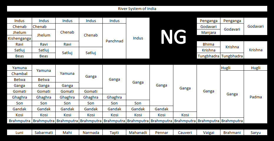
The Ganges is a trans-boundary river of Asia which flows through India and Bangladesh. The 2,525 km (1,569 mi) river rises in the western Himalayas in the Indian state of Uttarakhand. It flows south and east through the Gangetic plain of North India, receiving the right-bank tributary, the Yamuna, which also rises in the western Indian Himalayas, and several left-bank tributaries from Nepal that account for the bulk of its flow. In West Bengal state, India, a feeder canal taking off from its right bank diverts 50% of its flow southwards, artificially connecting it to the Hooghly River. The Ganges continues into Bangladesh, its name changing to the Padma. It is then joined by the Jamuna, the lower stream of the Brahmaputra, and eventually the Meghna, forming the major estuary of the Ganges Delta, and emptying into the Bay of Bengal. The Ganges–Brahmaputra–Meghna system is the second-largest river on earth by discharge.

<span class="mw-page-title-main">Geography of India</span>

India is situated north of the equator between 8°4' north to 37°6' north latitude and 68°7' east to 97°25' east longitude. It is the seventh-largest country in the world, with a total area of 3,287,263 square kilometres (1,269,219 sq mi). India measures 3,214 km (1,997 mi) from north to south and 2,933 km (1,822 mi) from east to west. It has a land frontier of 15,200 km (9,445 mi) and a coastline of 7,516.6 km (4,671 mi).

<span class="mw-page-title-main">Brahmaputra River</span> River in Tibet, India and Bangladesh

The Brahmaputra is a trans-boundary river which flows through Tibet (China), Northeastern India, and Bangladesh. It is known as Brahmaputra or Luit in Assamese,Yarlung Tsangpo in Tibetan, the Siang/Dihang River in Arunachali and Jamuna River in Bengali. It is the 9th largest river in the world by discharge, and the 15th longest.

<span class="mw-page-title-main">Yamuna</span> River in India

The Yamuna is the second-largest tributary river of the Ganges by discharge and the longest tributary in India. Originating from the Yamunotri Glacier at a height of about 4,500 m (14,800 ft) on the southwestern slopes of Bandarpunch peaks of the Lower Himalaya in Uttarakhand, it travels 1,376 kilometres (855 mi) and has a drainage system of 366,223 square kilometres (141,399 sq mi), 40.2% of the entire Ganges Basin. It merges with the Ganges at Triveni Sangam, Prayagraj, which is a site of the Kumbh Mela, a Hindu festival held every 12 years.

<span class="mw-page-title-main">Indo-Gangetic Plain</span> Geographical plain in South Asia

The Indo-Gangetic Plain, also known as the North Indian River Plain, is a 700-thousand km2 (172-million-acre) fertile plain encompassing northern regions of the Indian subcontinent, including most of modern-day northern and eastern India, most of eastern-Pakistan, virtually all of Bangladesh and southern plains of Nepal. Also known as the Indus–Ganga Plain, the region is named after the Indus and the Ganges rivers and encompasses a number of large urban areas. The plain is bounded on the north by the Himalayas, which feed its numerous rivers and are the source of the fertile alluvium deposited across the region by the two river systems. The southern edge of the plain is marked by the Deccan Plateau. On the west rises the Iranian Plateau. Many developed cities like Delhi, Dhaka, Kolkata, Lahore, Islamabad and Karachi are located in the Indo-Gangetic Plain.

<span class="mw-page-title-main">Ravi River</span> River in India and Pakistan

The Ravi River is a transboundary river crossing northwestern India and eastern Pakistan. It is one of five rivers associated with the Punjab region.

<span class="mw-page-title-main">Aravalli Range</span> Mountain range in western India

The Aravalli Range is a mountain range in Northern-Western India, running approximately 670 km (420 mi) in a south-west direction, starting near Delhi, passing through southern Haryana, Rajasthan, and ending in Ahmedabad Gujarat. The highest peak is Guru Shikhar on Mount Abu at 1,722 m (5,650 ft). The Aravalli Range is arguably the oldest geological feature on Earth, having its origin in the Proterozoic era.

<span class="mw-page-title-main">Sutlej</span> River in Asia

The Satluj River is the longest of the five rivers that flow through the historic crossroads region of Punjab in northern India and Pakistan. The Sutlej River is also known as Satadru. It is the easternmost tributary of the Indus River. The Bhakra Dam is built around the river Sutlej to provide irrigation and other facilities to the states of Punjab, Rajasthan and Haryana.

<span class="mw-page-title-main">Ghaghara</span> Asian river and tributary of the Ganges

The Ghaghara River, called Karnali River in Nepal, Mapcha Tsangpo in Tibet, and the lower Ghaghara in Awadh called Sarayu River, is a perennial trans-boundary river that originates in the northern slopes of the Himalayas in the Tibetan Plateau, cuts through the Himalayas in Nepal and joins the Sharda River at Brahmaghat in India. Together they form the Ghaghara River, a major left-bank tributary of the Ganges. With a length of 507 km (315 mi), it is the longest river in Nepal. The total length of the Ghaghara up to its confluence with the Ganges at Revelganj in Bihar is 1,080 km (670 mi). It is the largest tributary of the Ganges by volume and the second largest by length after Yamuna.

<span class="mw-page-title-main">Chambal River</span> River in India

The Chambal River is a tributary of the Yamuna River in Central and Northern India, and thus forms part of the drainage system of the Ganges. The river flows north-northeast through Madhya Pradesh, running for a time through Rajasthan, then forming the boundary between Rajasthan and Madhya Pradesh before turning southeast to join the Yamuna in Uttar Pradesh state.

<span class="mw-page-title-main">Ganges Basin</span> Part of the Ganges-Brahmaputra basin

The Ganges Basin is a major part of the Ganges-Brahmaputra-Meghna (GBM) basin draining 1,999,000 square kilometres in Tibet, Nepal, India and Bangladesh. To the north, the Himalaya or lower parallel ranges beyond form the Ganges-Brahmaputra divide. On the west the Ganges Basin borders the Indus basin and then the Aravalli ridge. Southern limits are the Vindhyas and Chota Nagpur Plateau. On the east the Ganges merges with the Brahmaputra through a complex system of common distributaries into the Bay of Bengal. Its catchment lies in the states of Uttar Pradesh (294,364 km2), Madhya Pradesh (198,962 km2), Bihar (143,961 km2), Rajasthan (112,490 km2), West Bengal (71,485 km2), Haryana (34,341 km2), Himachal Pradesh (4,317 km2), Delhi, Arunachal Pradesh (1,484 km2), the whole of Bangladesh, Nepal and Bhutan. Several tributaries rise inside Tibet before flowing south through Nepal. The basin has a population of more than 500 million, making it the most populated river basin in the world.

<span class="mw-page-title-main">Banas River</span> River in Rajasthan, India

The Banas is a river which lies entirely within the state of Rajasthan in western India. It is a tributary of the Chambal River, itself a tributary of the Yamuna, which in turn merges into the Ganga. The Banas is approximately 512 kilometres in length.

The Berach River, a tributary of the Banas River, is a river of Rajasthan state in western India. The river belongs to the Ganga River basin. The Berach originates in the hills of Udaipur district, northeast of Udaipur, and has a length of 157 km and basin area of 7,502 km². It flows northeast through Udaipur, Chittorgarh and Bhilwara districts, joining the Banas near Bigod village of Bhilwara district.

<span class="mw-page-title-main">Indian rivers interlinking project</span> Project to interlink rivers of India

The Indian Rivers Inter-link is a proposed large-scale civil engineering project that aims to effectively manage water resources in India by linking Indian rivers by a network of reservoirs and canals to enhance irrigation and groundwater recharge, reduce persistent floods in some parts and water shortages in other parts of India. India accounts for 18% of the world population and about 4% of the world's water resources. One of the solutions to solve the country's water woes is to link rivers and lakes.

<span class="mw-page-title-main">Rivers in Himachal Pradesh</span>

Himachal Pradesh provides water to both the Indus and Ganges basins. The drainage systems of the region are the Chenab, the Ravi, the Beas, the Satluj and the Yamuna. These rivers are perennial and are fed by snow and rainfall. They are protected by an extensive cover of natural vegetation.

<span class="mw-page-title-main">Sahibi River</span> River in India

The Sahibi river, also called the Sabi River, is an ephemeral, rain-fed river flowing through Rajasthan, Haryana and Delhi states in India. It originates in the eastern slopes of the Saiwar Protected Forest (PF) hills in Sikar District, enters Jaipur district near the foot of these hills, and after initially flowing southeast and east turns northeastwards near Shahpura and continues further till it exits Rajasthan to enter Haryana and further drains into Yamuna in Delhi, where its channeled course is also called the Najafgarh drain, which also serves as Najafgarh drain bird sanctuary. It flows for 300 km of which 157 km is in Rajasthan 100 km is in Haryana and 40 km in Delhi.

The Indori river, is a rain-fed river originates from Aravalli Range from Sikar district and flows through Alwar district of Rajasthan to Rewari district of Haryana and it is the longest tributary of Sahibi River which stretches to 50 km. In Delhi, it is called the Najafgarh drain or Najafgarh Nallah.

The Krishnavati river, also called Kasaunti, is a rain-fed river originates from Aravalli Range near Dariba copper mines in Rajsamand district of Rajasthan, and flows through Patan in Dausa district and Mothooka in Alwar district and then disappears in Mahendragarh district in Haryana where it use to be a tributary of Sahibi River, which in turn still is a tributary of Yamuna. Several Ochre Coloured Pottery culture sites have been found along the banks of Krishnavati, Sahibi river, Dohan river and Sota River. The drainage pattern for all these rivers is dendritic.

The Dohan river, is a rain-fed river that originates at Mandholi village near Neem Ka Thana in Sikar district of Rajasthan and then disappears in Mahendragarh district in Haryana where it used to be a tributary of Sahibi River, which in turn is a still flowing tributary of Yamuna. Its canalised portion in one of its paleochannel in Haryana is called the "Outfall Drain No 8".

References

  1. Sunil Vaidyanathan, Rivers of India, ISBN   978-8189738884, 2012
  2. "Archived copy" (PDF). Archived from the original (PDF) on 2015-05-14. Retrieved 2015-09-03.{{cite web}}: CS1 maint: archived copy as title (link) page no 361
  3. Gupta, S.P., ed. (1995), The lost Sarasvati and the Indus Civilization, Jodhpur: Kusumanjali Prakashan
  4. Cultural Contours of India: Dr. Satya Prakash Felicitation Volume, Vijai Shankar Śrivastava, 1981. ISBN   0391023586
  5. "Sahibi river". Archived from the original on 2017-10-12. Retrieved 2017-06-18.
  6. "Books: Page 41, 42, 43, 44, 47 (b) Sahibi Nadi (River), River Pollution, By A.k.jain". Archived from the original on 2023-07-16. Retrieved 2023-03-17.
  7. Minerals and Metals in Ancient India: Archaeological evidence, Arun Kumar Biswas, Sulekha Biswas, University of Michigan. 1996. ISBN   812460049X.
  8. "ganga - INDIA WRIS WIKI". India Wris Wiki. 24 August 2021. Archived from the original on 16 July 2023. Retrieved 7 September 2023.
  9. 1 2 3 FAO, India - Rivers Catchment Archived 2014-04-11 at the Wayback Machine , Aquastat, United Nations (2011)
  10. K.L. Rao, India's Water Wealth, ISBN   978-8125007043, 1979