Yerla River

Last updated
Yerla River
Nandre Badhara on Yerla River.jpg
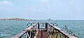
Nandre Bandhara on Yerla River, Sangli
Location
Country India
State Maharashtra
RegionSouth Maharashtra
District Satara, Sangli
Physical characteristics
Source Mhaskoba Hills, Manjarwadi [1]
  location Khatav Taluka, Satara, Maharashtra, India
  coordinates 17°52′47″N74°16′2″E / 17.87972°N 74.26722°E / 17.87972; 74.26722
  elevation947 m (3,107 ft) [2]
Mouth Krishna River
  location
Bramhanal, Sangli, Maharashtra, India [3]
  coordinates
16°55′57″N74°30′37″E / 16.93250°N 74.51028°E / 16.93250; 74.51028
Basin features
Tributaries 
  left Bhagyaganga River, Chand River [4] [5]
  right Nandani River

The Yerla River, alternatively Yerala River, is a tributary of Krishna River. It originates from the Mhaskoba hills in the extreme north of Khatav taluka of Satara district. It flows along a valley flanked by the Vardhangad range to its right and the Mahimangad range to its left and its total length is about 125 km. [6] In Satara district, it passes through Mol, Lalgun, Pusegaon, Khatav, Vaduj and Nimsod. Later in Sangli district it joins Krishna River near Brahmanal. The Yerala is nonperennial river. This river is a major source of irrigation in the eastern part of Satara district and Sangli district in Maharashtra and helpful for seasonal agriculture production. The drainage network influences the economic and social development of people. [7]

Contents

Places and Temples

The first holy place on the river is Mhaskoba Temple, where the river originates. This temple is located near to village Mol in north of Khatav taluka. After flowing in the south-east direction, the major attraction on this river is the Nagnath Temple of Lord Shiva at Nagnathwadi near Lalgun. Later the river enters in Ner dam which is an attractive place for seasonal migratory birds. [8] In Pusegaon there is a famous temple of Shri Sevagiri Maharaj on the bank of Yerala river. [9] At Yeralwadi near Banpuri village the beautiful Yeralwadi dam is constructed on this river at the south of Vaduj. The region of Yeralwadi Dam is a birding hotspot in Satara district. Greater flamingoes, winter migratory ducks, waders have a great diversity in this region. Brahmanal in Sangli district has a beautiful confluence of river Yerala and river Krishna.

Dams

Related Research Articles

Kirloskarvadi is India's second oldest industrial township that developed around the Kirloskar Brothers Ltd factory in the Palus Sangli district, in Maharashtra state, India. It is the second oldest industrial township in India. On 10 March 2010, Kirloskarvadi celebrated 100 years of its establishment. Kirloskarvadi is a rapidly growing satellite suburb of Palus city. The famous holy place of God Datta Maharaj Audumbar is just 10 km away. While Sagareshwar picnic spot is around 8–10. The town has centric connectivity between Satara-Sangli-Kolhapur

<span class="mw-page-title-main">Bhima River</span> Major river in southwest India

The Bhima River is a major river in Western India and South India. It flows southeast for 861 kilometres (535 mi) through Maharashtra, Karnataka, and Telangana states, before entering the Krishna River. After the first sixty-five kilometers in a narrow valley through rugged terrain, the banks open up and form a fertile agricultural area which is densely populated.

<span class="mw-page-title-main">Satara district</span> District of Maharashtra in India

Satara district is a district of Maharashtra state in western India with an area of 10,480 km2 (4,050 sq mi) and a population of 3,003,741 of which 14.17% were urban. Satara is the capital of the district and other major towns include Medha, Wai, Karad, Koregaon, Rahimatpur, Dahiwadi, Koynanagar, Phaltan, Lonand, Mahabaleshwar, Panchgani, Vaduj and Mhaswad. This district comes under Pune Administrative Division along with Pune, Sangli, Solapur and Kolhapur. The district of Pune bounds it to the north, Raigad bounds it to the north-west, Solapur the east, Sangli to the south, and Ratnagiri to the west.

<span class="mw-page-title-main">Sangli district</span> District of Maharashtra in India

Sangli district is a district of Maharashtra state in India. Sangli city is the district headquarters. It is bordered by Satara district, Solapur district to the North, Karnataka state to South-East, by Kolhapur district to South-West and by narrow portion in East side to Ratnagiri district. It is present on the southern tip of Maharashtra.

Tasgaonpronunciation Tasgaon is a city in Maharashtra and a municipal council in Sangli district in the Indian state of Maharashtra. Tasgaon city is developing city in Maharashtra. Tasgaon was given as Jahagir to Parshuram Bhau Tasgaonkar by Narayanrao Ballal Peshwa in 1774. Tasgaon Sansthan was lapsed by British during ruling of Shrimant Ganpatrao Tasgaonkar.

Khatav is a town and taluka located in the Man-Khatav subdivision of the Satara district, India.

Atpadi is an administrative town of the Atpadi Taluka of Sangli District in the Indian state of Maharashtra. Atpadi is located north-east of Sangli District and shares borders with the adjacent Solapur and Satara Districts. The town has a taluka administrative office, a courthouse, a police station, a government-run primary hospital, various schools and colleges and a theater. Atpadi's economy is based on the cultivation and sale of agricultural products, with pomegranates and cotton constituting the core of the industry. The town is also home to the Manganga Sahakari Sugar factory, a Pomegranate auction center and various small scale industries in fields such as manufacturing, processing, servicing and repairs.

Palus is a city and municipal council in sangli district.Palus is developed city in Sangli district. City have best industrial zone, steel firms, foundries and Precision Machine shop.

Maan is not a city name. Dahiwadi taluka is called as Maan taluka because land it's situated on Maan river that reason it's called Maan.Sub division dahiwadi is in Satara district of Maharashtra in India. Dahiwadi is tehsil place of maan taluka.

Nrusinhawadi commonly known as Narsobawadi or Narsobachi Wadi is a small town in Shirol Tahasil in Kolhapur district, Maharashtra. Narsobawadi gets its name from the presence of 'Shri Nrusinha Saraswati', the Purna Avatar of Lord Dattatreya.

Yeralwadi Dam, is an earthfill dam on Yerala river near Khatav, Satara district in the state of Maharashtra in India.

Yetgaon is a village situated in Kadegaon taluka in Sangli district, in the Indian state of Maharashtra.

<span class="mw-page-title-main">Ninam, Satara</span> Village in Maharashtra

Ninam is a census village in Satara district, in the Indian state of Maharashtra. It is a village surrounded by greenery and farms but also mountains. Agriculture is the main land use in the village with more than 75% of the total area being used for agricultural activities. The village close to historic Ajinkyatara fort, which is to the north. The large Jyotirlinga temple is in the center of the village.

<span class="mw-page-title-main">Vaduj</span> City in Maharashtra, India

Vaduj is a major town in Satara district of Maharashtra, India. It is the headquarters of Khatav Taluka. It is located on the banks of the Yerala River, and is around 58 kilometres (36 mi) away from the district capital Satara, and 165 kilometres (103 mi) away from Pune. It is the biggest town in Khatav Taluka, with a population of around 17,636 people. Recently, its status was changed to Nagar Panchayat.

Garavadi (Ramnagar) is a census village in the Satara district, which is located in the India state of Maharashtra. There are a total of approximately 240 families residing within its borders. The village is located in the Khatav Tehsil of Satara district in Maharashtra, India. It is 32 km away from the sub-district headquarters of Vaduj, and 54 km away from the district headquarters of Satara. Research from 2009 shows that Garavadi village is also classified as a gram panchayat. According to the India Census in 2011, the village was recorded to have a population of 997, 478 of which were males, and the other 519 females.

<span class="mw-page-title-main">Lalgun</span> Lalgun Village in Maharashtra

Lalgun is a village in the Satara district of the state of Maharashtra in India. It is located on Pusegaon-Phaltan State Highway and comes under Koregaon assembly constituency and Satara Parliamentary constituency. Lalgun has a population of about 2930.

<span class="mw-page-title-main">Pusegaon</span> Pusegaon- a village in Satara, Maharashtra, India

Pusegaon is a town in the Satara district of the state of Maharashtra in India. It is situated on the NH-548C Satara-Baitul National Highway. Pusegaon is known for the Shree Sevagiri Maharaj Temple & its annual Rathotsava fair.

<span class="mw-page-title-main">Nagnathwadi</span> Village in Maharashtra, India

Nagnathwadi is a village near to Lalgun in Satara district of Maharashtra state in India. It is known for the Lord Nagnatha Temple located on bank of Yerla river.

<span class="mw-page-title-main">Nandani River</span> River in Maharashtra, India

The Nandani River is a right tributary of Yerla River in India. It originates at Jaigaon and flows from Aundh in Satara district and confluence to Yerala river near Shivani village of Kadegaon taluka, in Sangli district of Maharashtra state.

Mayani is a town in Satara district of Maharashtra state in India. It is situated on the National Highway NH-160. This town is well known for a notified Bird Conservation Reserve in 2021.

References

  1. "Yerla River source" (PDF). Water Resource Department, Govt. of Maharashtra. Retrieved 3 March 2023.
  2. Yerla River. "Report on Aquifer Maps & Ground Water Management Plan, Khatav Taluka, Satara, Maharashtra (Part-I)" (PDF). Central Ground Water Board, Govt. of India. Retrieved 28 January 2023.
  3. "Yerla River mouth/confluence" (PDF). Water Resource Department, Govt. of Maharashtra. Retrieved 3 March 2023.
  4. "Chand River". Sakal Newspaper. Retrieved 23 April 2023.
  5. "Identification of Groundwater Potential Zones in Khatav Tahsil using Geospatial Techniques" (PDF). International Journal of Applied Information Systems (IJAIS). 9-No.7. September 2015. Retrieved 23 April 2023.
  6. "Yerla River length" (PDF). Water Resource Department, Govt. of Maharashtra. Retrieved 3 March 2023.
  7. Yerla River. "District Survey Report 2020-2021 (Draft)". District Mining Officer Satara, Maharashtra. Retrieved 28 December 2022.
  8. "Ner Dam". Sakal News Paper. Retrieved 6 February 2023.
  9. "Shri Sevagiri Maharaj temple" (PDF). Govt. of Maharashtra. Retrieved 12 February 2023.

Coordinates: 16°55′57″N74°30′37″E / 16.93250°N 74.51028°E / 16.93250; 74.51028