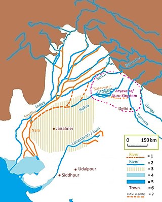
The Sarasvati River is a deified river first mentioned in the Rigveda and later in Vedic and post-Vedic texts. It played an important role in the Vedic religion, appearing in all but the fourth book of the Rigveda.

The Himalayas, or Himalaya, is a mountain range in Asia, separating the plains of the Indian subcontinent from the Tibetan Plateau. The range has some of the Earth's highest peaks, including the very highest, Mount Everest. Over 100 peaks exceeding 7,200 m (23,600 ft) in elevation lie in the Himalayas.
The Ravi River is a transboundary river crossing northwestern India and eastern Pakistan. It is one of five rivers associated with the Punjab region.

Kinnaur district is one of the twelve administrative districts of the state of Himachal Pradesh in northern India. The district is divided into three administrative areas and has six tehsils. The administrative headquarters of the district is at Reckong Peo. The mountain peak of Kinnaur Kailash is found in this district. As of 2011, it is the second least populous district of Himachal Pradesh, after Lahaul and Spiti.

The Sutlej or Satluj River is the longest of the five rivers that flow through the historic crossroads region of Punjab in northern India and Pakistan. The Sutlej River is also known as Satadru. It is the easternmost tributary of the Indus River. The Bhakra Dam is built around the river Sutlej to provide irrigation and other facilities to the states of Punjab, Rajasthan and Haryana.

Kinnauri, also known as Kanauri, Kanor, Koonawur, Kanawari or Kunawar, is a Sino-Tibetan dialect cluster centered on the Kinnaur district of the Indian state of Himachal Pradesh.

Bushahr, also spelt as 'Bashahr' and 'Bussahir' or 'Bushair' was a Rajput princely state in India during the British Raj. It was located in the hilly western Himalaya promontory bordering Tibet in the northern part of colonial Punjab region.
The Ghaggar-Hakra River is an intermittent river in India and Pakistan that flows only during the monsoon season. The river is known as Ghaggar before the Ottu barrage, and as Hakra downstream of the barrage in the Thar Desert. In pre-Harappan times the Ghaggar was a tributary of the Sutlej. It is still connected to this paleochannel of the Sutlej, and possibly the Yamuna, which ended in the Nara River, presently a delta channel of the Indus River joining the sea via Sir Creek.

The Pir Panjal Range is a chain of mountains in the Lower Himalayan region located in the Western Himalayas of northern Indian subcontinent. It runs southeast to northwest between the Beas and Neelam/Kishanganga rivers, in the Indian territories of Himachal Pradesh and Jammu and Kashmir, with its northwestern end extending into Pakistan. The Himalayas show a gradual elevation towards the Dhauladhar and Pir Panjal ranges. Pir Panjal is the largest range of the Lesser Himalayas. Near the bank of the Sutlej River, it dissociates itself from the Himalayas and forms a divide between the Beas and Ravi rivers on one side and the Chenab on the other. Further west, the Pir Panjal range separates the Kashmir Valley from the hills of Jammu region.

The Tons is the largest tributary of the Yamuna. It flows through Garhwal region in Uttarakhand, touching Himachal Pradesh. The Tons thrust is named after this river.

The state of Himachal Pradesh is spread over an area 55,673 km2 (21,495 sq mi) and is bordered by Jammu and Kashmir and Ladakh on the north, Punjab on the southwest, Haryana on the south, Uttarakhand on the southeast, a small border with Uttar Pradesh in the south, and Tibet on the east. Entire Himachal Pradesh lies in the mountainous Himalaya region, rich in natural resources
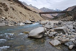
Sangla is a town in the Baspa Valley, also referred to as the Sangla valley, in the Kinnaur District of Himachal Pradesh, India, close to the Tibetan border.

Baspa Valley is a river valley that is said to be named after the Baspa River. It lies in the Kinnaur District of Himachal Pradesh, India. Sangla is a major town in the Baspa Valley, and the valley is also known as the Sangla Valley or Tukpa Valley. The villages inside the valley is Chitkul, Rakchham, Batseri, Sangla, Kamru; the old capital of Bushahr State and Chansu.

Spiti is a high-altitude region of the Himalayas, located in the north-eastern part of the northern Indian state of Himachal Pradesh. The name "Spiti" means "The middle land", i.e. the land between Tibet and India. Spiti incorporates mainly the valley of the Spiti River, and the valleys of several rivers that feed into the Spiti River. Some of the prominent side-valleys in Spiti are the Pin valley and the Lingti valley. Spiti is bordered on the east by Tibet, on the north by Ladakh, on the west and southwest by Lahaul, on the south by Kullu, and on the southeast by Kinnaur. Spiti has a cold desert environment. The valley and its surrounding regions are among the least populated regions of India. The Bhoti-speaking local population follows Tibetan Buddhism.

Chhitkul is a village in Kinnaur district of Himachal Pradesh. During winters, the place mostly remains covered with the snow and the inhabitants move to lower regions of Himachal.
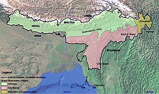
The Eastern Himalayas extend from eastern Nepal across Northeast India, Bhutan, the Tibet Autonomous Region to Yunnan in China and northern Myanmar. The climate of this region is influenced by the monsoon of South Asia from June to September. It is a biodiversity hotspot, with notable biocultural diversity.

The Western Himalayan alpine shrub and meadows is a montane grasslands and shrublands ecoregion of Nepal, India, and Tibet, which lies between the tree line and snow line in the western portion of the Himalaya Range.

The topography of Pakistan is divided into seven geographic areas: the northern highlands, the Indus River plain, the desert areas, the Pothohar Plateau, Balochistan Plateau, Salt Range, and the Sistan Basin. All the rivers of Pakistan, i.e. Sindh, Ravi River, Chenab River, Jhelum River, and Sutlej River, originate from the Himalayas mountain range. Some geographers designate Plateau as to the west of the imaginary southwest line; and the Indus Plain lies to the east of that line.
The Western Himalayas refers to the western half of the Himalayas, in northern Pakistan and northwestern India. It is also known as the Punjab Himalayas. Four of the five tributaries of the Indus River in Punjab rise in the Western Himalayas; while the fifth, the Sutlej cuts through the range after rising in Tibet.
Tourism in Himachal Pradesh relates to tourism in the Indian state of Himachal Pradesh. This is popularly renowned for its Himalayan landscapes and popular hill-stations. Many outdoor activities such as rock climbing, mountain biking, paragliding, ice-skating, trekking, rafting, and heli-skiing are popular tourist attractions in Himachal Pradesh.