
The Beas River is a river in north India. The river rises in the Himalayas in central Himachal Pradesh, India, and flows for some 470 kilometres (290 mi) to the Sutlej River in the Indian state of Punjab. Its total length is 470 kilometres (290 mi) and its drainage basin is 20,303 square kilometres (7,839 sq mi) large.

The Sutlej or Satluj River is the longest of the five rivers that flow through the historic crossroads region of Punjab in northern India and Pakistan. The Sutlej River is also known as Satadru. It is the easternmost tributary of the Indus River. The Bhakra Dam is built around the river Sutlej to provide irrigation and other facilities to the states of Punjab, Rajasthan and Haryana.
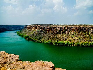
The Chambal River is a tributary of the Yamuna River in Central and Northern India, and thus forms part of the drainage system of the Ganges. The river flows north-northeast through Madhya Pradesh, running for a time through Rajasthan then forming the boundary between Rajasthan and Madhya Pradesh before turning southeast to join the Yamuna in Uttar Pradesh state.
Bilaspur is a town and a municipal council in Bilaspur district in the Indian state of Himachal Pradesh.

Bhakra Nangal Dam is a concrete gravity dam on the Satluj River in Bhakra Village near Bilaspur in Bilaspur district, Himachal Pradesh in northern India. The dam forms the Gobind Sagar reservoir.

GandhisagarDam is situated at a distance of 168 km from the District headquarter. The Dam is constructed on the Chambal River.

The state of Himachal Pradesh is spread over an area 55,673 km2 (21,495 sq mi) and is bordered by Jammu and Kashmir and Ladakh on the north, Punjab on the southwest, Haryana on the south, Uttarakhand on the southeast, a small border with Uttar Pradesh in the south, and Tibet on the east. Entire Himachal Pradesh lies in the mountainous Himalaya region, rich in natural resources
Dehra Gopipur is a town, a Municipal Council, and a Tehsil in Kangra district in the state of Himachal Pradesh, India. The River Beas divides the town into Dera & Gopipur. The town of Dehra is as recent as mid-15th century when foreign invaders used this place as a dera (camp) for their expedition to hill states. British made the evolving town as the tehsil in year 1868. The official name of the town during British Raj was Dera.

Maharana Pratap Sagar, also known as Pong Reservoir or Pong Dam Lake is a large reservoir in Fatehpur, Jawali and Dehra tehsil of Kangra district of the state of Himachal Pradesh in India. It was created in 1975, by building the highest earthfill dam in India on the Beas River in the wetland zone of the Siwalik Hills. Named in the honour of Maharana Pratap (1540–1597), the reservoir or the lake is a well-known wildlife sanctuary and one of the 49 international wetland sites declared in India by the Ramsar Convention. The reservoir covers an area of 24,529 hectares, and the wetlands portion is 15,662 hectares.
Gobind Sagar Lake is a reservoir situated in Una and Bilaspur districts of Himachal Pradesh, India. It is formed by the Bhakra Dam.

Kareri Lake is a shallow high elevation fresh water lake located on the southern spur of the Dhauladhar range approximately 9 km northwest of Dharamsala in Kangra district, Himachal Pradesh, India.

The Rana Pratap Sagar Dam is a gravity masonry dam of 53.8 metres (177 ft) height built on the Chambal River at Rawatbhata in Rajasthan in India. It is part of integrated scheme of a cascade development of the river involving four projects starting with the Gandhi Sagar Dam in the upstream reach in Madhya Pradesh and the Jawahar Sagar Dam on the downstream with a terminal structure of the Kota Barrage in Rajasthan for irrigation.
Himachal Pradesh is extremely rich in its hydroelectricity resources. The state has about twenty five percent of the national potential. About 27,436 MW of hydroelectric power can be generated in the state by the construction of various hydroelectric projects on the five perennial river basins. Out of total hydroelectric potential of the state, 10,519 MW is harnessed so far, out of which only 7.6% is under the control of Himachal Pradesh Government while the rest is exploited by the Central Government. The state government has been giving the highest priority for its development, since hydroelectric generation can meet the growing need of power for industry, agriculture and rural electrification. It is also the biggest source of income to the state as it provides electricity to other states.
The Jawahar Sagar Dam is the third dam in the series of Chambal Valley Projects on the Chambal River, located 29 km upstream of Kota city and 26 km downstream of Rana Pratap Sagar dam. It is a concrete gravity dam, 45 meters high and 393 meters long, generating 60 MW of power with an installed capacity of 3 units of 33 MW. Its construction was completed in 1972. The dam's gross storage capacity is 67.07 million cubic meters. The total catchment area of the dam is 27,195 km2, of which only 1,496 km2 are in Rajasthan. The free catchment area below Rana Pratap Sagar dam is 2,331 km2. The dam is located after the Gandhi Sagar Dam and Rana Pratap Sagar Dam, but before the Kota Barrage.

The Koldam Hydropower Station commonly known as Koldam, is an embankment dam on the Sutlej River upstream of the Dehar Power House. It is 18 km from Bilaspur off the Chandigarh-Manali Highway (NH-21) near Barmana, Himachal Pradesh, India. The main purpose of the dam is hydroelectric power generation and it will support an 800 MW power station. The dam was constructed by NTPC Limited.

The Pandoh Dam is an embankment dam on the Beas River in Mandi district of Himachal Pradesh, India. Under the Beas Project, the dam was completed in 1977 and its primary purpose is hydroelectric power generation. Part of a run-of-the-river power scheme, it diverts the waters of the Beas to the southwest through a 38 km (24 mi) long system of tunnels and channels. The water is used for power generation at the Dehar Power House before being discharged into the Sutlej River, connecting both rivers. The power house has an installed capacity of 990 MW. The system diverts 256 cumecs of Beas waters to the Satluj River. The project was completed in 1977.
Jawali is a town in Kangra District of Himachal Pradesh State in India.Old name of Jawali is Jawanwalashehar. Jawali is the second largest Assembly constituency in the state of Himachal Pradesh. It is located 250 km distance from its State Capital, Shimla and is located 50 km distance from its District headquarters Dharamshala.

Jahu is a village panchayat in Bhoranj tehsil, of the Hamirpur district, Himachal Pradesh, India. Jahu is on a trijunction of Hamirpur, Bilaspur and Mandi districts.
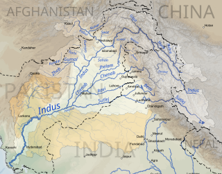
The Indus basin is the part of Asia drained by the Indus river and its tributaries. The basin covers an area of 1,120,000 km2 (430,000 sq mi) traversing four countries: Afghanistan, China, India and Pakistan, with most of the area lying predominantly in the latter two.
