
Bangladesh is a densely populated, low-lying, mainly riverine country located in South Asia with a coastline of 720 km (447 mi) on the northern littoral of the Bay of Bengal. The delta plain of the Ganges (Padma), Brahmaputra (Jamuna), and Meghna Rivers and their tributaries occupy 79 percent of the country. Four uplifted blocks occupy 9 percent and steep hill ranges up to approximately 1,000 metres (3,300 ft) high occupy 12 percent in the southeast and in the northeast. Straddling the Tropic of Cancer, Bangladesh has a tropical monsoon climate characterised by heavy seasonal rainfall, high temperatures, and high humidity. Natural disasters such as floods and cyclones accompanied by storm surges periodically affect the country. Most of the country is intensively farmed, with rice the main crop, grown in three seasons. Rapid urbanisation is taking place with associated industrial and commercial development. Exports of garments and shrimp plus remittances from Bangladeshis working abroad provide the country's three main sources of foreign exchange income.

Kemijoki, with its 550 km (340 mi) length, is the longest river in Finland. It runs through Kemijärvi and Rovaniemi before reaching the Gulf of Bothnia at Kemi.

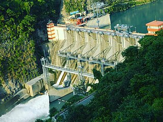
Davis Dam is a dam on the Colorado River about 70 miles (110 km) downstream from Hoover Dam. It stretches across the border between Arizona and Nevada. Originally called Bullhead Dam, Davis Dam was renamed after Arthur Powell Davis, who was the director of the U.S. Bureau of Reclamation from 1914 to 1923. The United States Bureau of Reclamation owns and operates the dam, which was completed in 1951.
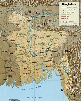
The Meghna River is one of the major rivers in Bangladesh, one of the three that form the Ganges Delta, the largest delta on earth, which fans out to the Bay of Bengal. A part of the Surma-Meghna River System, Meghna is formed inside Bangladesh in Kishoreganj District above the town of Bhairab Bazar by the joining of the Surma and the Kushiyara, both of which originate in the hilly regions of eastern India as the Barak River. The Meghna meets its major tributary, the Padma, in Chandpur District. Other major tributaries of the Meghna include the Dhaleshwari, the Gumti, and the Feni. The Meghna empties into the Bay of Bengal in Bhola District via four principal mouths, named Tetulia (Ilsha), Shahbazpur, Hatia, and Bamni.
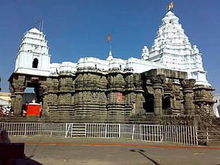
Hingoli district is an administrative district in the state of Maharashtra in India. The district is headquartered at Hingoli. The district occupies an area of 4,526 km2 and has a population of 11,77,345 of which 15.60% were urban. Hingoli was actually known as the Nizams military base as it was bordered with Vidharbha. In that era military troops, hospitals, veterinary hospital were in operation from Hingoli. Being a military base the city was one of the important and famous places of the Hyderabad state. One of the twelve Jyotirlinga shrines, the Aundha Nagnath is located in Hingoli district about 25 km south-west from district headquarter.
The Jamuna River is one of the three main rivers of Bangladesh. It is the lower stream of the Brahmaputra River, which originates in Tibet as Yarlung Tsangpo, before flowing into India and then southwest into Bangladesh. The Jamuna flows south and joins the Padma River (Pôdda), near Goalundo Ghat, before meeting the Meghna River near Chandpur. It then flows into the Bay of Bengal as the Meghna River.
The Dhaleshwari River is a distributary, 160 kilometres (99 mi) long, of the Jamuna River in central Bangladesh. It starts off the Jamuna near the northwestern tip of Tangail District. After that it divides into two branches: the north branch retains the name Dhaleshwari and merges with the other branch, the Kaliganga River at the southern part of Manikganj District. Finally the merged flow meets the Shitalakshya River near Narayanganj District. This combined flow goes southwards to merge into the Meghna River.

Banda district is a district of Uttar Pradesh state of India, and Banda is the district headquarters. It is a part of Chitrakoot Division.

Dakshin Dinajpur, also known as South Dinajpur, is a district in the Indian state of West Bengal, India. It was created on 1 April 1992 by the division of the erstwhile West Dinajpur District. The Headquarter (sadar) of the district is at Balurghat. It comprises two subdivisions: Balurghat and Gangarampur. According to the 2011 census, it is the third least populous district of West Bengal.

Observatory Circle is a street in Washington, D.C. It runs from Calvert Street to Massachusetts Avenue near 34th Street. Established in 1894, the street follows an incomplete loop, forming an arc rather than a circle. Number One Observatory Circle is the official residence of the Vice President of the United States.

North East Delhi is one of the eleven administrative district of Delhi, India. The district was established in 1997. North East Delhi borders the Yamuna River on the west, Ghaziabad District to the north and east, East Delhi to the south, and North Delhi to the west across the Yamuna. Karawal Nagar, Seelampur and Yamuna Vihar are 3 sub-divisions of this district.
The Bangali River is one of the main rivers in the northern part of Bangladesh. As of 2007, the river is in the news because of the possibility that it might merge with the Jamuna River, which could lead to major changes in the geography of the region.

The Lempa River is a 422-kilometre-long (262 mi) river in Central America.
Hariabhanga River (also spelt Haribhanga) is a tidal estuarine river in and around the Sundarbans in North 24 Parganas district in the Indian state of West Bengal, bordering on Satkhira District of Bangladesh.
The Ichari Dam is a concrete gravity dam on the Tons River 13 km (8 mi) north of Dakpathar in Uttarakhand, India. The primary purpose of the dam is hydroelectric power production and it is a run-of-the-river-type. It was completed in 1972. The dam diverts water to the Chibro Power Station which is then returned to the Tons River before being fed to the Khodri Power Station.

The Dakpathar Barrage is a concrete barrage across the Yamuna River adjacent to Dakpathar in Uttarakhand, India. In a run-of-the-river scheme, the barrage serves to divert water into the East Yamuna Canal for hydroelectric power production at the Dhakrani and Dhalipur Power Plants. The foundation stone for the dam was laid on 23 May 1949 by India's Prime Minister Jawaharlal Nehru. The barrage is controlled by 25 floodgates and has a length of 516.5 m (1,695 ft).

Jamuna River is a tributary of the Ichamati River. It flows through the Indian state of West Bengal and is one of the major rivers of the North 24 Parganas district.

The Small Jamuna River is a river in North Bengal, Bangladesh. In 2007, it was observed that the river might merge with the Jamuna River. It passes through Joypurhat and Naogaon
The Jhenai River is located in Bangladesh. It forms as an offshoot of the old channel of the Brahmaputra River, most of the water of which now flows through the Jamuna. The Jhenai divides, with the main branch joining the Jamuna south of Sarishabari in Jamalpur District and another branch flowing south in Tangail District.

Yamula Dam is a dam and hydroelectric plant in Kayseri Province on Kızılırmak River, central Turkey.