Chitkul | |
|---|---|
village | |
 Mathi temple at Chitkul, the locals say it could be 500 years old. | |
 Chitkul Location in Himachal Pradesh, India  Chitkul Chitkul (India) | |
| Coordinates: 31°21′07″N78°26′13″E / 31.3518411°N 78.4368253°E | |
| Country | |
| State | Himachal Pradesh |
| District | Kinnaur |
| Elevation | 3,450 m (11,320 ft) |
| Population (2010) | |
• Total | 882 |
| Languages | |
| • Official | Hindi |
| Time zone | UTC+5:30 (IST) |
| PIN | 172106 |
| Vehicle registration | HP- |
| Nearest city | Rampur |
| Climate | Alpine climate (Köppen) |
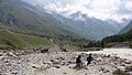
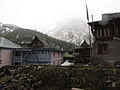
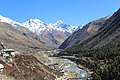
Chitkul is a village in Kinnaur district of Himachal Pradesh. During winters, the place mostly remains covered with snow and the inhabitants move to lower regions of Himachal.
Contents
According to a recent study by Centre of Atmospheric Sciences at IIT Delhi, Chitkul has the cleanest air in India. [1] [2]