Alwar district

Last updated • 4 min readFrom Wikipedia, The Free Encyclopedia

Alwar district
Alwar fort or Bala Quila 07.jpg
Moosi Maharani ki Chattri - City Palace, Alwar.jpg
Bhangarh Fort - Royal Palace Bhangarh (July 2022) - img 04.jpg
Shiv Mandir, Neelkanth.jpg
Water body within the Sariska Reserve, Rajasthan.jpg
Clockwise from top-left: Alwar fort, Musi Maharani ki Chhatri, Neelkanth Shiv Mandir, Sariska Tiger Reserve, Bhangarh Fort
Alwar in Rajasthan (India).svg
Location of Alwar district in Rajasthan
Coordinates(Alwar): 27°34′12″N76°36′00″E / 27.57000°N 76.60000°E / 27.57000; 76.60000
CountryFlag of India.svg  India
State Rajasthan
Division Jaipur
Headquarters Alwar
Tehsils (22) Alwar, Govindgarh, Tehla, Kathumar, Laxmangarh, Rajgarh, Ramgarh, Thanagazi, Pratapgarh, Reni, Malakhera, Narayanpur, Naugaon
Government
   District Collector & Magistrate Ashish Gupta, IAS [1]
   Superintendent of Police Anand Sharma, IPS [2]
Area
  Total
8,337 km2 (3,219 sq mi)
Population
 (2022 [3] )
  Total
4,125,512
  Density490/km2 (1,300/sq mi)
Demographics
   Literacy 71.68%
  Sex ratio894
Time zone UTC+05:30 (IST)
Vehicle registration RJ-02
Website alwar.rajasthan.gov.in

Alwar is a district in the state of Rajasthan in northern India, whose district headquarters is Alwar city. The district covers 8,337 km2. It is bound on the north by Rewari district of Haryana, on the east by Bharatpur district of Rajasthan and Nuh district of Haryana, on the south by Dausa district, and on the west by Jaipur district.

Contents

As of 2011 it is the third most populous district of Rajasthan (out of 33) after Jaipur and Jodhpur. [4]

Administration

Alwar district has 18 tehsils: [5] Alwar, Bansur, Behror, Govindgarh, Kathumar, Kishangarh Bas, Kotkasim, Laxmangarh, Mundawar, Rajgarh, Ramgarh, Thanagazi, Tijara, Neemrana, Reni, Malakhera Naugawan Tapukara

It has only one Lok Sabha constituency, Alwar.

Industry

The district has industrial estates such as Alwar, Bhiwadi, Shahjahanpur, Neemrana, Behror where companies such as G. S. Pharmbutor, Ashok Leyland, Pepsi, Parryware, Kajaria Ceramics, and Honda Motors have manufacturing plants.

Agriculture

New residential buildings in Neemrana Alwar Under construction residential Buildings.jpg
New residential buildings in Neemrana Alwar

Alwar has an important place in agriculture production in Rajasthan. The total geographical area of the district is 8,38,000 hectares [6] which is about 2.5 percent of the State. In 2010–2011 the net cultivated area is 5,07,171 hectares from which about 83 percent area viz. – 4,51,546 is irrigated and the remaining 17 percent area viz. – 82,903 is unirrigated. Double cropped area is nearly 2,52,000 hectares of which 32,230 (12%) is irrigated and remaining 2,19,819 (88%) is unirrigated. Thus, the total cropped area of the district is 8,12,873 hectares. In Kharif season bajra, maize, Jowar, Kharif pulses, Arhar, sesamum, cotton, guar etc. [7] are sown in about 3,29,088 hectares (42%) and in Rabi season wheat, barley, gram, mustard, taramira, rabi pulses are sown in about 4,52,527 hectares (58%). The main source of irrigation are wells and tube wells. By 26064 tube wells, about 192861-hectare area is being irrigated and by 57196 Wells about 265169 hectares area is irrigated. By other sources like canals, tanks about 404 hectares area is irrigated. About 35470 electric motors and 66502 Diesel pump sets are being used for irrigation purposes. The normal rainfall for the district is 657.3 mm. The average rainfall in the last ten years in the district is 724 mm. The rainfall distribution in the district is uneven and scattered which resulted in some times flood problems and some time drought position which affect the agriculture production as well as cropping pattern in Kharif & Rabi season. Thus, the agriculture in the district by and large depends on rainfall distribution. The average rainfall in 2016 up to September is 217 mm.

Places of interest

Alwar fort Alwar fort or Bala Quila 02.jpg
Alwar fort

Bala Qilla (Alwar fort) situated in the Aravali Hills [8] is one of the best forts present in Rajasthan. It is said that it has never been invaded or conquered by any king. Just behind it is the Nikumbh Mahal. There are many small palaces in the city and an old museum with a collection of paintings, armours, and old weapons.

Neelkanth temple is an old temple dedicated to Lord Shiva, built between the 6th to the 9th century.

Bhangarh Haunted Fort

Neemrana Fort Palace near Behror, 70 km from Alwar City Neemrana fort.jpg
Neemrana Fort Palace near Behror, 70 km from Alwar City

Banghar Fort is a haunted fort and the Archaeological Survey of India has put up a board on the fort gate that it is prohibited for tourists to stay inside the fort area after sunset and before sunrise. This fort has become a major tourist attraction. [9]

This Royal Rao Haveli (300 years old), Nizam Nagar (Laxmangarh) is only 25 km from Kesroli fort, Agara-Delhi Road. Ruled & established by H.H.Rao Bhero Singh (Riyastdar), who was the Relative of H.H Yashwant Singh, the king Of Alwar.

Sariska Tiger Reserve is also located in the district, and Arvari River flows through this district. Hill Fort Kesroli, currently a heritage hotel, is also nearby at Kesroli.

Neemrana is an important heritage fort on NH-48 near Behror.

Demographics

Religions in Alwar District (2011) [10]
ReligionPercent
Hinduism
82.72%
Islam
15.90%
Sikhism
1.76%
Other or not stated
0.62%

According to the 2011 census Alwar district has a population of 3,674,179, [4] roughly equal to the nation of Liberia [11] or the US state of Oklahoma. [12] This gives it a ranking of 77th in India (out of a total of 640). [4] The district has a population density of 438 inhabitants per square kilometre (1,130/sq mi) . [4] Its population growth rate over the decade 2001-2011 was 22.7%. [4] Alwar has a sex ratio of 894 females for every 1000 males, [4] and a literacy rate of 71.68%. 17.81% of the population lives in urban areas. Scheduled Castes and Scheduled Tribes make up 17.77% and 7.87% of the population respectively. [4]

Alwar districtcomes under mainly Mewat and Ahirwal or Rath region. Behror, Mundawar, Neemrana, Bhiwadi, Tijara tehsils come under Ahirwal region. Ramgarh, kishangarh Bas, Tijara, Govindgarh, Laxmangarh comes under Mewat Region. Rajgarh, Reni, Thana Ghazi tehsils come under Meenawati and Dhundhar Region. Kathumar, Laxmangarh, Govindgarh, Ramgarh Tehsils come under Mewat - Braj Region.

Languages

Languages in Alwar District (2011) [13]

   Hindi (85.27%)
   Mewati (7.90%)
   Rajasthani (1.99%)
   Rathi (1.02%)
  Others (3.82%)

Mewati, Rajasthani and Rathi are main language of Alwar. Mewati and Braj are spoken in East Alwar. Ahirwati is spoken in North and West Alwar. Mewati and Jaipuri (Rajasthani) is spoken in South and South west Alwar.

Historical population
YearPop.±% p.a.
1901851,285    
1911811,689−0.48%
1921718,788−1.21%
1931768,324+0.67%
1941843,576+0.94%
1951861,896+0.22%
19611,089,561+2.37%
19711,390,724+2.47%
19811,755,217+2.35%
19912,295,648+2.72%
20012,991,552+2.68%
20113,674,179+2.08%
source: [14]

Transport

National Highway NH8 (Delhi-Jaipur-Ajmer-Ahmedabad-Bombay highway) passes through the Behror district. Alwar district is reached from New Delhi by NH8 or by Gurgaon-Sohna-Alwar highway that is being widened to six lanes.

Delhi-Jaipur railway line also passes through the district. Alwar city railway station is one of the railway stations in the district.

Education

Related Research Articles

<span class="mw-page-title-main">Alwar</span> City in Rajasthan, India

Alwar is a city located in India's National Capital Region (NCR) and the administrative headquarters of Alwar District in the state of Rajasthan. It is located 150 km south of Delhi and 150 km north of Jaipur.

<span class="mw-page-title-main">Mewat</span> Historical and cultural region in northwestern India

Mewat is a historical and cultural region which encompasses parts of the modern-day states of Haryana, Rajasthan, and Uttar Pradesh in northwestern India.

<span class="mw-page-title-main">Bharatpur district</span> District of Rajasthan in India

Bharatpur District is a district in Rajasthan state in western India. The city of Bharatpur is the District Headquarters, Division Headquarters and Headquarters of Bharatpur

Dhundhari (ढूंढाड़ी), also known as Jaipuri, is a Rajasthani language within the Indo-Aryan language family. It is spoken in the Dhundhar region of northeastern Rajasthan state, India. Dhundari-speaking people are found in four districts – Jaipur, Sawai Madhopur, Dausa, Tonk and some parts of Sikar, Karauli and Gangapur District.

<span class="mw-page-title-main">Behror</span> City in Rajasthan, India

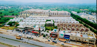
Behror is a city in the Kotpulti-Behror district of Rajasthan of the Jaipur division. It serves as the administrative headquarters of the eponymous Behror Tehsil and shares headquarters for Kotputli-Behror district with Kotputli. It is equidistant from both state capital Jaipur and national capital New Delhi. Located 120 km south-west of New Delhi and as a part of National Capital Region, it is regulated under National Capital Region Planning Board which is a federal authority for urban planning purposes in NCR. Along with Shahjahanpur and Neemrana it is grouped as SNB Complex (Shahjahanpur-Neemrana-Behror) of NCR- which includes 137 revenue villages, in which Behror municipality is the largest urban conglomeration. This region is also known as 'Ahirwal region' or simply as Raath and is an important industrial hub for the state of Rajasthan. Behror municipality spreads out in an area of 15 km2 is divided into four revenue villages namely Behror tarf Gangabishan, Behror tarf Doongrasi, Behror tarf Nainsukh, Behror tarf Balram.

Mandawar is a town in the Dausa district in the Indian state of Rajasthan. It is located about 140 km (87 mi) from the state capital, Jaipur and 250 km (160 mi) from Delhi.for ro sale and service please make call 9024242690

Tijara is a city and a municipality in Khairthal-Tijara district of the Indian state of Rajasthan. Tijara comes under the NCR area and is situated 55 km to the northeast of Alwar. The nearest railway station to Tijara is Khairthal. Bhiwadi is a census town in Tijara. It is the biggest industrial area of Rajasthan and part of the historical Ahirwal Mewat region. Tijara is dominated by Ahir and Meo community. The new political map has not erased the ancient Ahirwal-Mewat boundaries.Ahirwal was a post-Mughal principality ruled by Ahirs or Yadavs.

The Neemrana Hotels is an Indian organisation, noted for restoring ruins and turning them into heritage hotels.

<span class="mw-page-title-main">Kotkasim</span> City in Rajasthan, India

Kotkasim is a City and Nagar Palika, near Tijara City in Khairthal-Tijara district of the Indian state of Rajasthan.

<span class="mw-page-title-main">Sahibi River</span> River in India

The Sahibi river, also called the Sabi River, is an ephemeral, rain-fed river flowing through Rajasthan, Haryana and Delhi states in India. It originates in the eastern slopes of the Saiwar Protected Forest (PF) hills in Sikar District, enters Jaipur district near the foot of these hills, and after initially flowing southeast and east turns northeastwards near Shahpura and continues further till it exits Rajasthan to enter Haryana and further drains into Yamuna in Delhi, where its channeled course is also called the Najafgarh drain, which also serves as Najafgarh drain bird sanctuary. It flows for 300 km of which 157 km is in Rajasthan 100 km is in Haryana and 40 km in Delhi.

Mundawar is a town and tehsil in Khairthal - Tijara district in Indian state of Rajasthan. Mundawar is 15 km from Khairthal city.

<span class="mw-page-title-main">Khanpur Ahir</span> Town in Rajasthan, India

Khanpur Ahir or Khanpur Aheer is a village, near Khairthal in Mundawar Mandal in Khairthal-Tijara district in the Indian state of Rajasthan. Khanpur Ahir is 15 km (9.3 mi) from its district headquarters Khairthal city. It is 140 km (87 mi) from its state capital, Jaipur.

<span class="mw-page-title-main">Kathumar</span> Town in Rajasthan, India

Kathumar is a town and tehsil of Alwar district in the Indian state of Rajasthan.

Khushkhera is an industrial area located within the Tijara Tehsil of the Khairthal-Tijara district within the Indian state of Rajasthan. The area falls within the Delhi NCR region.

Nasopur is a village in Kotkasim, Tehsil Alwar district, in the Indian state of Rajasthan. It is located around 75 km south of Delhi, 75 km north of Alwar, and about 200 km north of Jaipur, the capital of Rajasthan. Nasopur is part of Greater Bhiwadi and National Capital Region (NCR).

Mahtawas is a village in Neemrana tehsil, Alwar district, Rajasthan state, India. It is a part of the National Capital Region.

Sanoda is a village in Kotkasim tehsil Alwar District in the state of Rajasthan, India.

<span class="mw-page-title-main">Khanpur Dagran</span> Village in Rajasthan, India

Khanpur Dagran, Khanpur Aheeran, Khanpur Ahir is a village in Kotkasim tehsil Alwar District in the state of Rajasthan, India. Khanpur Dagran part of Ahirwal and about 85 percent of the total population are Yadav. Most of the Yadavs belong to the gotra(clan) of the Dagar. The main language spoken in Ahirwati.

Gandala is a Gram Panchayat Village and Up-Tehsil in Behror tahsil/Sub-district, Alwar, Rajasthan, India. It is the second largest Village by population in Behror Tehsil after Bardod Village according to 2011 Census of India and situated on Behror-Kund Road. It is 7 km from Sub-district headquarters and 70 km from District headquarters. It is 140 km from state capital and 120 km from national capital .The village is well known for its ancient temple which is named after Sati Nihali Mata. The main occupation of people in this rural area is Agriculture.The Majority population in village mainly Deeva gotra Yadavs. Part of Goad Village, Narnaul, Haryana.

<span class="mw-page-title-main">Kotputli-Behror district</span> District in Rajasthan, India

Kotputli-Behror is a district in the state of Rajasthan. This district was carved out from erstwhile Jaipur district and Alwar district and was formally established on 7 August 2023. It is located in north-eastern part of Rajasthan. The districts is surrounded on three sides with Aravali Ranges with Sabi river flowing through it. It comprises Tehsils of Kotputli, Behror, Neemrana, Bansur, Mandhan, Paota, Viratnagar and Narayanpur. District headquarters are Kotputli. Piyadasi as name of Emperor Ashoka was found out form the Bhabru rock edicts found in the district. A major part of the district comprising Tehsils of Behror, Neemrana, Bansur, Mandhan and is referred to as Rath Region though Mundawar tehsil of Rath region was made part of separate district of Khairthal.

References

  1. "Alwar Administration". Alwar.rajasthan.gov.in. 22 February 2024.
  2. "अलवर के नए SP बने आनंद शर्मा, गार्ड ऑफ ऑनर के साथ पुलिस जवानों ने दी सलामी". 18 February 2024.
  3. "Rajasthan (India): Districts, Cities and Towns - Population Statistics, Charts and Map".
  4. 1 2 3 4 5 6 7 "District Census Handbook 2011 - Alwar" (PDF). Census of India . Registrar General and Census Commissioner of India.
  5. "Welcome to Alwar, The Gateway of Rajastan > Administrative Setup Of Alwar District". Alwar.nic.in. Archived from the original on 6 March 2013. Retrieved 7 March 2013.
  6. "पोर्टल, राजस्थान सरकार". alwar.rajasthan.gov.in. Retrieved 26 May 2023.
  7. "Agriculture Contingency Plan for District: Alwar" (PDF). agricoop.nic.in.
  8. "Bala Quila Fort - Rajasthan Traditional". Archived from the original on 26 May 2023. Retrieved 26 May 2023.
  9. "Bhangarh Fort: The 'most haunted' place in India?". Times of India. IANS. 15 July 2013. Archived from the original on 18 July 2013.
  10. "Table C-01 Population By Religion - Rajasthan". census.gov.in. Registrar General and Census Commissioner of India.
  11. US Directorate of Intelligence. "Country Comparison:Population". Archived from the original on 13 June 2007. Retrieved 1 October 2011. Liberia 3,786,764 July 2011 est.
  12. "2010 Resident Population Data". U. S. Census Bureau. Archived from the original on 19 October 2013. Retrieved 30 September 2011. Oklahoma 3,751,351
  13. "Table C-16 Population by Mother Tongue: Rajasthan". censusindia.gov.in. Registrar General and Census Commissioner of India.
  14. "Decadal Variation In Population Since 1901".