Mandrayal

Last updated

Mandrayal
Town
India Rajasthan location map.svg
Red pog.svg
Mandrayal
Location in Rajasthan, India
India location map.svg
Red pog.svg
Mandrayal
Mandrayal (India)
Coordinates: 26°18′N77°14′E / 26.3°N 77.23°E / 26.3; 77.23
CountryFlag of India.svg  India
State Rajasthan
District Karauli
Elevation
262 m (860 ft)
Population
 (2001)
  Total23,118
Languages
  Official Hindi
Time zone UTC+5:30 (IST)
PIN
322251
Telephone code07464-226...
ISO 3166 code RJ-IN
Vehicle registration RJ-

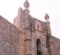
Mandrayal is a town in the state of Rajasthan, India. According to a census from 2011, Mandrayal has a population of 8,590; while the population of Mandrayal Tehsil is 74,600.[ citation needed ]

Contents

History

Mandrayal MANDRAYAL.jpg
Mandrayal

Mandrayal is the main town in the Karauli district. It joins the two states of Madhya Pradesh and Rajasthan and is famous for its history. In 1534, Puranmal, the Raja of Amber, fought in favour of Mughals in the Battle of Mandrayal. The following year, Bahadur Shah of Gujrat besieged the fort of Chittor. Humayun fought against him. Bharmal's policy towards Mughals was merely an extension of his brother's policy.[ citation needed ]

Population

As of the 2011 Census of India, Mandrayal was home to 1588 households. Its population owas 8,590 of which 4,586 were male and 4,004 female. The number of children with age 0-6 was 1412 and the Average Sex Ratio was 873, which was lower than the Rajasthan state average of 928. The Child Sex Ratio was 940, higher than the Rajasthan average of 888.

Mandrayal village has a higher literacy rate compared to Rajasthan. In 2011, the literacy rate of Mandrayal village was 70.30% compared to 66.11% of Rajasthan. In Mandrayal Male literacy stands at 82.81% while the female literacy rate was 55.75%. It is administrated by a Sarpanch (Head of Village), who is an elected representative.

Festivals

The main religious festivals are Deepawali, Holi, Gangaur, Teej, Gogaji, Makar Sankranti and Janmashtami, as the main religion is Hinduism. Rajasthan's annual winter desert festival is also celebrated.

Related Research Articles

Sisai is one of the biggest villages in Bihar. It comes under Siwan District, India, located about 42 km by road and 52 km by train route north of the Chhapra. It is a typical village of Bihar. From September to April, a blanket is necessary during nights. It is the biggest village in Siwan. It has 51 tola. It comes under Goriyakothi Police Station and Sisai Panchayat. There is a famous middle school which built in 1916. It is bounded by Chhitaouli from north, Bishunpur from South, Angya from East and Pahlegpur from West.

<span class="mw-page-title-main">Jakhal</span> Village in Rajasthan, India

Jakhal is a village located in the Nawalgarh tehsil of Jhunjhunu district of Rajasthan, India. It is located in shekhawati region, approx. 35 km south of Jhunjhunu city and 20 km east of Nawalgarh. Jakhal was founded by Salehadi Singh Shekhawat on 9 August 1732. Although hundreds of Jakhal's residents serve in the armed forces, the village's main occupation is farming. In the monsoon seasons, the main crops are bajara, moth, and guar, but in winter, the main crops are wheat, barley, sarson, and chana (chickpeas). The major part of the population belongs to Jat community with Moond, Khedar and garhwal Jat gotras.

Govindgarh is a census town in Jaipur district in the Indian state of Rajasthan.

Modak is a census town in Kota district in the Indian state of Rajasthan. Modak is in Ramganjmandi Tehsil. It is located 61 km south of Kota, the district headquarters.

Sadulshahar is a town and a municipality in Sri Ganganagar district in the Indian state of Rajasthan.

Leeli is a village in the Alwar district of Rajasthan in India. With 727 families, it is the largest village located in Malakhera Tehsil.

Kodamthuruth is a village in Alappuzha district in the Indian state of Kerala. It is a panchayat, which comes under the Aroor Assembly constituency.

Kabbur is a town in the southern state of Karnataka, India. It is located in the Chikodi taluk of Belgaum district in Karnataka.

Antana is a village in the Hadoti region of Rajasthan, India. It serves as a Gram panchayat for two nearby villages: Musen Mata and Ummedganj. The nearest town is Atru, which is 8 km away. It is located 32 km from the district headquarters, Baran.

Madlur is a village in the Belgaum district of Karnataka State, India. The village is famous for its history and its also called Siddhabhoomi. The place was once ruled by the Chalukyas. The ancient village is rich with the architecture of the Chalukyas. The Historical name of the place is Shreerangapur. Shree Shiddeshwar temple and Koranar Bhavi are the major attractions. Other major attractions are Marakumb Kola and lake Maagani.

Bhinder or Bhindar is a town in Udaipur District, that is located 315 km (196 mi) from the state's main city Jaipur. Bhinder borders the Chittorgarh District in Rajasthan and is located 58 kilometres (36 mi) south-east of Udaipur. Notable tourist sites nearby include Sita Mata Wildlife Sanctuary, Jaisamand Sanctuary, and Jaisamand Lake. Bhinder is surrounded by four lakes.

Kheri Shilla is a village in Makrana tehsil in Nagaur district, Rajasthan state of India. It is 7 km from Gachhipura. Other names for Kheri Shella are Mundelo Ki kheri and Guda Kheri, and the latest name of is Devnagari Kheri Sheela.

Jalimpura also known as Charna ki dhani is a village in Bhimsar gram panchayat, Mandawa, Tehsil, Jhunjhunu district, Rajasthan, India. All resident of the village belongs to Jaat community.

Boraj Tawaran is a village in the Udaipur district of Rajasthan, India. It comes under the Malpur gram panchayat, in Salumber block. The village is located 8 km east of Salumber. It is also known as Boraj Tanwaran or Boraj Tavraan. Salumbar is nearest town to Boraj Tawaran village.Around 1700 CE, a Thakur of the Tanwar clan moved to Salumber during the rule of Rawat Kesari Singh Chundawat. In 1876, his descendant Thakur Tej Singh Tanwar was granted the jagir of the present-day village site to Rawat Jodh Singh Chundawat.

<span class="mw-page-title-main">Malwas</span>

Malwas is a village and post in the Churu district of northern Rajasthan state, India.

Vatav is a small village located in Petlad Taluka in Anand district, Gujarat, India. As of the 2011 Census of India, it had a population of 2,484. The pin code of Vatav is 388450.

Deengli is a village in Rajgarh, Churu, Rajasthan, India. As per 2011 Census of India, the village has population of 2197 of which 1144 are males while 1053 are females. It comes under ‘’’Sulkhnia chhotta’’’ Panchayath. It belongs to Bikaner Division. As per constitution of India and Panchyati Raaj Act, Deengli village is administrated by Sarpanch who is elected representative of village. It is located 65 km towards East from District headquarters Churu. 230 km from State capital Jaipur. The most famous place in Deengli is Net Dada JI temple.

Chamundery Ranawatan is a large village located in Bali of Pali district, Rajasthan with total 1616 families residing. The Chamunderi Rana Watan village has population of 7854 of which 4007 are males while 3847 are females as per Population Census 2011.

<span class="mw-page-title-main">Sowaddi Kalan</span> Village in Punjab, India

Sowaddi Kalan or Swaddi Khas is a village in Ludhiana district in the Indian state of Punjab. Kalan is Persian language word which means Big. It is one of the most educated villages in the area. Swaddi Kalan is a large village in Jagraon of Ludhiana district with a total of 954 families and 4,804 residents in 2011.

Khindas is a village in Bikaner district Rajasthan state of India.

References