
Hanumangarh is a city and municipal council in the Indian state of Rajasthan, situated on the banks of the river Ghaggar also identified as ancient Sarasvati river, located about 400 km from Delhi. It is the administrative headquarter of Hanumangarh District. The city was once called Bhatner because it was founded by king Bhupat in 255 AD. It remained in the control of the Rajputs of Bhati clan and faced a historic siege by Timur in 1391, during which the Bhati Raput king Dulachand lost the fort for a short time. The fort was later occupied by Rao Jetsa of Bikaner.

Sri Ganganagar is the northernmost city of the Indian state of Rajasthan, near the international border of India and Pakistan. It is the administrative headquarters of Sri Ganganagar district. It is named after Maharaja Shri Ganga Singh Bahadur, Maharaja of Bikaner. The city is also known as the "Food Basket of Rajasthan".
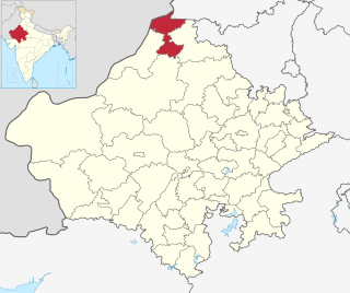
Sri Ganganagar district is the northernmost district of Rajasthan state of India.
Sumerpur is a city in the south part of Pali District of Rajasthan state in India. Named after Maharaja Sumer Singh of Jodhpur, it came into existence in 1912 on the northern bank of Jawai river. The town is headquarters of the Sumerpur revenue subdivision and Sumerpur Tahsil. Sumerpur is an important agricultural mandi for Pali, Sirohi and Jalore districts.

Anupgarh is a town in the state of Rajasthan in India. It is administrative headquarters of the Anupgarh district, which was formed on 17 March 2023.
Bhawani Mandi is a town and a municipality in Jhalawar district in the state of Rajasthan, India.
Dostpur is a town and a nagar panchayat in Sultanpur district in the state of Uttar Pradesh, India. The town borders Sultanpur and Ambedkarnagar. Purvanchal Expressway passes near the town.
Gajsinghpur is a town near the border area in Sri Ganganagar district in the Indian state of Rajasthan. Census of 2011 is 9995.
Kesrisinghpur is a town and a municipality in Ganganagar district in the Indian state of Rajasthan.

Padampur is a City and a municipality, just 39 km from Sri Ganganagar city in Sri Ganganagar District in the Indian state of Rajasthan. The city was named after Rajkumar Padam Singh of royal family of Bikaner.
Pinahat is a town and a nagar panchayat in Agra district in the Indian state of Uttar Pradesh and situated on the Bank of Chambal River. It is about 55 km from Agra. The distance between Pinahat and Chambal is only 2 km.
Sadulshahar is a town and a municipality in Sri Ganganagar district in the Indian state of Rajasthan.
Vijaynagar or Vijaynagar is a town and a municipality in Sri Gangangaar district in the Indian state of Rajasthan.
Banga is a town and Municipal council in the Shaheed Bhagat Singh Nagar district of Punjab, India. Banga is also one of the sub-division (tehsil) headquarters of the district. Banga is located on Phagwara-Rupnagar section of National Highway 344A. It is currently estimated to have a population of about 23,000 and is classified as a class 2 Municipality. The town also incorporates the former village of Jindowal apart from Banga town.

Dewa Sharif or Dewa is a town and a nagar panchayat in Barabanki district in the state of Uttar Pradesh, India. It is famous for the shrine of Haji Waris Ali Shah. This town is also known by the name of Dewa Sharif in respect for the shrine. It is about 26 km north-east of the state capital Lucknow.
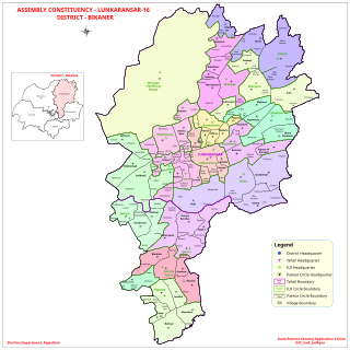
Lunkaransar is a town, near city of Bikaner in the Bikaner district of Indian state of Rajasthan. Lunkaransar lake in Rajasthan is a playa lake formed due to deflation. Lunkaransar is most popular for Peanuts in Rajasthan.
Karanpur tehsil is one of the nine tehsils in Sri Ganganagar district, Rajasthan. It is located in the north-western part of the district. The city of Karanpur serves as the headquarters of the tehsil. Its north-western border adjoins Bahawalnagar district in Pakistani Punjab. To the east, it is bordered by Shriganganagar tehsil and Padampur tehsil, and to the south by Raisinghnagar tehsil.
Raisinghnagar Tehsil is a tehsil of Anupgarh district, Rajasthan, India. It is in the central-western area of the district. Raisinghnagar is the headquarters of the tehsil. Sameja and Muklawa are Sub Tehsil in Raisinghnagar

Anupgarh district is a new north-west district of Rajasthan state in India. It was established on 7 August 2023 after curving it out of Sri Ganganagar District.
Badlapur is an administrative division in Jaunpur District in the Indian state of Uttar Pradesh. It was accorded the status of Town Area Nagar Panchayat on 27 June 2014.

