
Sri Ganganagar is the northernmost city of the Indian state of Rajasthan, near the international border of India and Pakistan. It is the administrative headquarters of Sri Ganganagar district. It is named after Maharaja Shri Ganga Singh Bahadur, Maharaja of Bikaner. The city is also known as the "Food Basket of Rajasthan".
Ambaji (Ambājī) is a census town in Banaskantha district in the state of Gujarat, India.

Hanumangarh district is a district in the state of Rajasthan in India. The city of Hanumangarh is the district headquarters and its largest city.
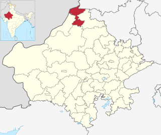
Sri Ganganagar district is the northernmost district of Rajasthan state in western India.
Phalodi is a municipality in Phalodi district in the Indian state of Rajasthan. It is the headquarters for Phalodi tehsil. Phalodi is also called the "salt city" due to the salt industry in Rin. Phalodi is in the buffer zone of Thar Desert and often subject to extreme temperature conditions due to its arid climate. It holds the record for the highest verified temperature recorded in Rajasthan at 51.0 °C (123.8 °F) on 19 May 2016. It is also the highest temperature ever recorded in India.
Raisinghnagar is a town and a municipality (Tehsil) in Anupgarh district in the Indian state of Rajasthan. The town is surrounded by fertile land.
Sadulshahar is a town and a municipality in Sri Ganganagar district in the Indian state of Rajasthan.
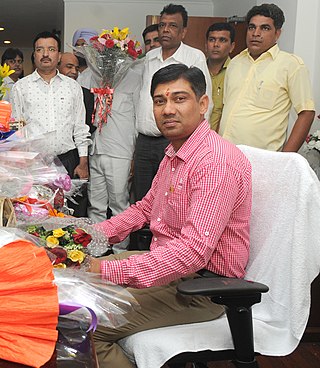
Nihal Chand Chauhan also known as Nihal Chand Meghwal is an Indian politician belonging to the Bharatiya Janata Party.
Amarpura Jatan is a small farming village in the Sri Ganganagar's Suratgarh municipality in the state of Rajasthan. It is located in the Bikaner district and is about 42.51 square kilometers in area.

Bahawalnagar Tehsil is a tehsil located in Bahawalnagar District, Punjab, Pakistan. There are two towns in Bahawalnagar Tehsil: Bahawalnagar and Dunga Bunga. The city of Bahawalnagar is the headquarters of the tehsil which is administratively subdivided into 31 Union Councils.

Haroonabad Tehsil is a tehsil located in Bahawalnagar District, Punjab, Pakistan. The city of Haroonabad is the headquarters of the tehsil which is administratively subdivided into 22 Union Councils.
Karanpur tehsil is one of the nine tehsils of Sri Ganganagar district, Rajasthan. It falls in the north-west of the district. Karanpur city is the headquarters of the tehsil. Its north-west border touches Bahawalnagar district of Pakistani Punjab. It is bordered in the east by Shriganganagar tehsil and Padampur tehsil, and in the south by Raisinghnagar tehsil.
Raisinghnagar Tehsil is a tehsil of Anupgarh district, Rajasthan, India. It is in the central-western area of the district. Raisinghnagar is the headquarters of the tehsil. Sameja and Muklawa are Sub Tehsil in Raisinghnagar
Anupgarh Tehsil is the one of Seven tehsils of Anupgarh district in Rajasthan, India. The tehsil headquarters are located at the town of Anupgarh.

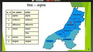
Anupgarh district is a new north-west district of Rajasthan state in India. Anupgarh city is district headquarter. It is carved out of Ganganagar district. Anupgarh, consists Raisinghjnagar, Anupgarh, Sri Vijaynagar, Gharsana Rawla, Chhatargarh. It was established on 7th August 2023.
Ratanpura is a village in Rajgarh tehsil of Churu district in Rajasthan. It was established in 1848, and is situated 45 km northeast of Churu and 17 km southwest of Rajgarh.
Gurudwara Buddha Johad(in Punjabi ਗੁਰੂਦੁਆਰਾ ਬੁੱਢਾ ਜੋਹੜ ,in Hindi and Rajasthani गुरूद्वारा बुड्ढा जोहड़)is a historical Gurudwara in Ganganagar district of Rajasthan, India. It was built in the remembrance of the event when Sukha Singh and Mehtab Singh brought here head of Massa Ranghar, who was guilty of sacrilege of Amritsar's Golden Temple.
Raisinghnagar Assembly constituency is one of constituencies of Rajasthan Legislative Assembly in the Ganganagar.
Lakha Hakam is a village in tehsil Raisinghnagar of Sri Ganganagar district in Rajasthan, India. It is situated near the border of India and Pakistan. This is a well-connected village. There is an ancient Peepal tree and a pond in the village. The Lakha Hakam name comes from a Muslim family. Around 250 years ago a morphine jaat son came here and took the land of Lakha Hakam and its total calculated land was approximately 42,000 BIGHHA on rent from King of Bikaner principality. The man is the founder of this remote village. The oldest police station is here.
National Highway 911, commonly referred to as NH 911 is a national highway in India. It is a spur road of National Highway 11. NH-911 runs in the state of Rajasthan in India. The route of national highway 911 was further extended to Sri Ganganagar in Rajasthan.

