Churu is a city in the desert region of Rajasthan state of India. It is known as the gateway to the Thar Desert of Rajasthan. It is the administrative headquarter of Churu District. It lies in the Thar Desert on the National Highway 52 connecting Sangrur to Ankola and is a junction station on the railway line to Bikaner. It is near the shifting sand dunes of the Thar Desert and has grand havelis with marvelous fresco paintings, namely Kanhaiya Lal Bagla Ki Haweli and Surana Haweli, with hundreds of small windows. It also has some fine Chhatris. Near the town is a religious seat of the Nath sect of Sadhus where there are life-size marble statues of their deities and a place for prayers. At the center of the town is a fort built about 500 years ago.

Bahawalpur District is a district of Punjab, Pakistan, with capital the city of Bahawalpur. According to the 1998 Census it had a population of 2,433,091, of which 27.01% were urban. Bahawalpur district covers 24,830 km2. Approximately two-thirds of the district (16,000 km2) is covered by the Cholistan Desert, which extends into the Thar Desert of India. The district is a major producer of cotton.

Sri Ganganagar is the northernmost city of the Indian state of Rajasthan, near the international border of India and Pakistan. It is the administrative headquarters of Sri Ganganagar district. It is named after Maharaja Shri Ganga Singh Bahadur, Maharaja of Bikaner. The city is also known as the "Food Basket of Rajasthan".

Taranagar is a city and a municipality in Churu district in the Indian state of Rajasthan, situated at 28° 41'N 75° 3'E, about 28 miles south of Churu City. Taranagar was earlier known as Reni, named for the lady Rinkali who came here to live from Vishalnagar Koyalapatan, currently Foga in Sardarshar (Rajasthan). Reni was the headquarters of the nizamat and the tehsil of the same name in the state of Bikaner in Rajputana. The nizamat consisted of five eastern tehsils of Bhadra, Churu, Nohar, Rajgarh and Reni. In 1948, the town was renamed for King Tara Singh, who ruled it in the mid-18th century.

Bikaner District is a district of the state of Rajasthan in western India. The historic city of Bikaner is the district headquarters. The district is located in Bikaner Division along with the three other districts of Anupgarh, Sri Ganganagar and Hanumangarh.
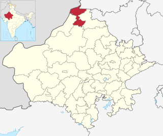
Sri Ganganagar district is the northernmost district of Rajasthan state of India.
Kesrisinghpur is a town and a municipality in Ganganagar district in the Indian state of Rajasthan.

Padampur is a City and a municipality, just 39 km from Sri Ganganagar city in Sri Ganganagar District in the Indian state of Rajasthan. The city was named after Rajkumar Padam Singh of royal family of Bikaner.
Vijaynagar or Vijaynagar is a town and a municipality in Anupgarh district in the Indian state of Rajasthan.

Rajasthan is a mineral-rich state and has a diversified economy having agriculture, mining and tourism as its main engines of growth. The state mines produce gold, silver, sandstone, limestone, marble, rock phosphate, copper and lignite. It is the second-largest producer of cement and contributes one tenth of the salt produced in India.
Maregaon is a town in Wani Subdivision of Yavatmal district in the Indian state of Maharashtra.
Ajeetpura is a town in the Hanumangarh district, Rajasthan state in India.
Goluwala is a city in Hanumangarh district of Rajasthan, India. It belongs to Bikaner division. It is divided into two suburbs– Niwadan (24JRK) and Sihagan (22JRK). It is an industrial town located some 31 km west of Hanumangarh and around 51 km off to Sri Ganganagar. Total Population of Goluwala Niwadan(24JRK) & Sihagan(22JRK) is 14960 (9753+5207) in 2011 census. Goluwala can be reached from Pilibangan, the nearest railway station. It is 18 km off National Highway 62 (India) and 431 km from State capital Jaipur.It is popular as name "Goluwala the Golden City".

Pratapgarh district is the 33rd district of Rajasthan, created on 26 January 2008. It is a part of Udaipur Division and has been carved out from the erstwhile tehsils of Chittorgarh, Udaipur and Banswara districts. Pratapgarh town is the administrative headquarters of the district.

Rawla Mandi is a town in Rawla Mandi tehsil of Anupgarh district of Rajasthan, India. It is located on Gharsana-Khajuwala road,50 kms from district headquarter Anupgarh and 27 km away from Gharsana and 180 km from the Sri Ganganagar. The state capital Jaipur is 480 km away, and national capital New Delhi is 500 km away. It is 33 km from Khajuwala and 122 km from Bikaner. It is 30 km far from Indo-Pak(India-Pakistan) border. Rawla mandi known as 8PSD (B) gram panchayt. Rawla Gaon Also located in West of rawla mandi
Datta is a village in Hansi Tehsil, Hisar district, in Haryana, India. It is situated 36 km from Hisar city and 20 km from Hansi city on the road which also leads to Barwala. At Data there is another road that leads to Narnaund. It is 15 km from Narnaund Tehsil and only 16 km from Barwala town. Datta comes under Roghi Khap Panchayat. There is an oil depot of HPCL situated on Bianakhera road.
Karanpur tehsil is one of the nine tehsils of Sri Ganganagar district, Rajasthan. It falls in the north-west of the district. Karanpur city is the headquarters of the tehsil. Its north-west border touches Bahawalnagar district of Pakistani Punjab. It is bordered in the east by Shriganganagar tehsil and Padampur tehsil, and in the south by Raisinghnagar tehsil.
Sri Vijaynagar Tehsil is the one of five tehsils of Anupgarh district of Rajasthan, India. It is located in the Eastern part of District Anupgarh. It is bordered by Anoopgarh tehsil in the west, by Raisinghnagar tehsil in the north, Suratgarh tehsil in the east, and Bikaner district in the south.
Gandala is a Gram Panchayat Village and Up-Tehsil in Behror tahsil/Sub-district, Alwar, Rajasthan, India. It is the second largest Village by population in Behror Tehsil after Bardod Village according to 2011 Census of India and situated on Behror-Kund Road. It is 7 km from Sub-district headquarters and 70 km from District headquarters. It is 140 km from state capital and 120 km from national capital .The village is well known for its ancient temple which is named after Sati Nihali Mata. The main occupation of people in this rural area is Agriculture.The Majority population in village mainly Deeva gotra Yadavs. Part of Goad Village, Narnaul, Haryana.

Malasar(हिंदी: मालासर) is a large village located in Bikaner District which is in the north-west of the state of Rajasthan, India. This village is the Panchayat headquarters of three nearby villages. There are a total of 450 houses in the village. This village is popular for its unique geographical location, beautiful sand dunes and sandy paths located in the heart of the Thar Desert.


