Bikaner district

Last updated

Bikaner district
20191211 Junagarh Fort, Bikaner, India 1547 8075 DxO.jpg
The magniifcent door construction of the Karni Mata Temple of Deshnoke.png
Bhandasar Jain temple exterior - 1.jpg
Bikaner jorbeed carcass dump habitat JEG4976.jpg
Bikaner-Devikund Sagar-04-2018-gje.jpg
Clockwise from top-left: Junagarh Fort, Karni Mata Temple, Thar Desert, Devikund Sagar, Bhandasar Jain Temple
Bikaner in Rajasthan (India).svg
Location of Bikaner district in Rajasthan
CountryFlag of India.svg  India
State Rajasthan
Division Bikaner
Headquarters Bikaner
Area
  Total30,247 km2 (11,678 sq mi)
Population
 (2011)
  Total2,363,937
  Density78/km2 (200/sq mi)
Time zone UTC+05:30 (IST)
Website bikaner.rajasthan.gov.in/content/raj/bikaner/en/home.html

Bikaner District is a district of the state of Rajasthan in western India. The historic city of Bikaner is the district headquarters. The district is located in Bikaner Division along with the three other districts of Anupgarh, Sri Ganganagar and Hanumangarh.

Contents

Geography

Rajasthan Canal (Indira Gandhi Canal) passing through Thar desert near Chhatargarh Bikaner district Rajasthan canal Shivender.jpg
Rajasthan Canal (Indira Gandhi Canal) passing through Thar desert near Chhatargarh Bikaner district

The district is bounded by Ganganagar district to the north, Hanumangarh district to the northeast, Churu district to the east, Nagaur district to the southeast, Jodhpur district to the south, Jaisalmer district to the southwest, and Punjab Province of Pakistan to the northwest.

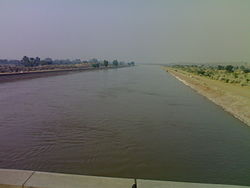
Bikaner district lies in the Thar Desert. The Indira Gandhi Canal, also known as the Rajasthan Canal, runs through the district from northeast to southwest, providing irrigation water for the district.

In October, 2020 an international group of researchers found a lost river that ran through the central Thar Desert  ; 1,72,000 years ago. [1]

Climate

Climate data for Bikaner
MonthJanFebMarAprMayJunJulAugSepOctNovDecYear
Average high °C (°F)23.0
(73.4)
25.5
(77.9)
31.8
(89.2)
38.2
(100.8)
41.7
(107.1)
41.6
(106.9)
37.8
(100.0)
36.6
(97.9)
36.7
(98.1)
36.2
(97.2)
30.7
(87.3)
25.3
(77.5)
33.8
(92.8)
Average low °C (°F)5.6
(42.1)
8.8
(47.8)
15.0
(59.0)
22.1
(71.8)
26.8
(80.2)
28.8
(83.8)
27.7
(81.9)
26.8
(80.2)
24.7
(76.5)
19.1
(66.4)
12.1
(53.8)
6.9
(44.4)
18.7
(65.7)
Average precipitation mm (inches)5
(0.2)
7
(0.3)
10
(0.4)
7
(0.3)
31
(1.2)
46
(1.8)
106
(4.2)
71
(2.8)
34
(1.3)
4
(0.2)
3
(0.1)
1
(0.0)
325
(12.8)
Average precipitation days0.81.01.50.92.63.26.65.63.00.60.30.526.6
Source: HKO

Administrative set-up

Bikaner district has eight sub-divisions called tehsils: Bikaner, Nokha, Loonkaransar, Shri Dungargarh, Kolayat, and Pugal. There are two sub-tehsils: Bajju is in Kolayat and Mahajan is in Loonkaransar.

There are 1498 villages and 290 gram panchayats. [2] There is one municipal corporation (Bikaner) and six municipal councils: Deshnok, Nokha, Dungargarh, Khajuwala, Loonkaransar and Napasar. The collector and district magistrate (DM) of Bikaner is Nimit Mehta [3] and additional magistrate is Sunita Chaudhary. [4]

Demographics

Historical population
YearPop.±% p.a.
1901216,478    
1911236,708+0.90%
1921228,562−0.35%
1931271,449+1.73%
1941360,968+2.89%
1951395,462+0.92%
1961511,317+2.60%
1971665,439+2.67%
1981973,800+3.88%
19911,381,201+3.56%
20011,902,110+3.25%
20112,363,937+2.20%
Source: [5]
Religions in Bikaner district (2011) [6]
ReligionPercent
Hinduism
87.71%
Islam
9.97%
Jainism
1.31%
Sikhism
0.85%
Other or not stated
0.16%

According to the 2011 census Bikaner district has a population of 2,363,937, roughly equal to the nation of Latvia or the US state of New Mexico. [7] [8] This gives it a ranking of 190th in India (out of a total of 640). The district is 30,247.90 km2 (11,678.78 sq mi). The district has a population density of 78 inhabitants per square kilometre (200/sq mi). Its population growth rate over the decade 2001-2011 was 41.42%. Bikaner has a sex ratio of 903 females for every 1,000 males, and a literacy rate of 65.92%. 33.86% of the population lives in urban areas. Scheduled Castes and Scheduled Tribes make up 20.88% and 0.33% of the population respectively. [9]

Languages

Languages of Bikaner District (2011) [10]

   Rajasthani (83.05%)
   Hindi (6.82%)
   Marwari (5.86%)
   Punjabi (1.27%)
   Sindhi (0.98%)
  Others (2.02%)

At the time of the 2011 Census of India, 81.09% of the population spoke Rajasthani, 14.94% Marwari, 2.05% Hindi, 1.71% Urdu and 0.98% Sindhi as their first language. [10]

See also

Related Research Articles

<span class="mw-page-title-main">Hanumangarh</span> City in Rajasthan, India

Hanumangarh is a city and municipal council in the Indian state of Rajasthan, situated on the banks of the river Ghaggar also identified as Ancient Sarasvati river, located about 400 km from Delhi. It is the administrative headquarter of Hanumangarh District. The city was once called Bhatner because it was founded by king Bhupat in 255 AD. It remained in the control of the Rajputs of Bhati clan and faced a historic siege by Timur in 1391, during which the Bhati Raput king Dulachand lost the fort for a short time. The fort was later occupied by Rao Jetsa of Bikaner.

<span class="mw-page-title-main">Sri Ganganagar</span> City in Rajasthan, India

Sri Ganganagar is the northernmost city of the Indian state of Rajasthan, near the international border of India and Pakistan. It is the administrative headquarters of Sri Ganganagar district. It is named after Maharaja Shri Ganga Singh Bahadur, Maharaja of Bikaner. The city is also known as the "Food Basket of Rajasthan".

<span class="mw-page-title-main">Jodhpur district</span> District of Rajasthan in India

Jodhpur District is a district in the State of Rajasthan in western India. The city of Jodhpur is the administrative headquarters of the district.

<span class="mw-page-title-main">Jaisalmer district</span> District of Rajasthan in India

Jaisalmer district is the largest district in the Indian state of Rajasthan, and the third largest district in India. Located in Marwar, the city of Jaisalmer is the administrative headquarters of the district. It is around 289 km (180 mi) from the city of Jodhpur, and around 559 km (347 mi) from Jaipur, the capital of Rajasthan. As of the 2011 population census, it is the least populous district out of all 33 districts in Rajasthan.

<span class="mw-page-title-main">Churu district</span> District of Rajasthan in India

Churu district is a district of the Indian state of Rajasthan in northern India. It was founded by Banirot Rajputs. Some believe it was a village of jats known as kalera ka bas. Thakur Kushal Singh constructed the Churu fort in 1649 and during the battle of 1871 the area came under dominance of Bikaner State. The town of Churu is the administrative headquarters of the district.

<span class="mw-page-title-main">Hanumangarh district</span> District in Rajasthan, India

Hanumangarh district is a district in the state of Rajasthan in India. The city of Hanumangarh is the district headquarters and its largest city.

<span class="mw-page-title-main">Sri Ganganagar district</span> District of Rajasthan in India

Sri Ganganagar district is the northernmost district of Rajasthan state in western India.

<span class="mw-page-title-main">Bikaner division</span>

Bikaner Division is one of the administrative geographical unit, called a division, of Rajasthan state, India. The division comprises four districts, namely, Bikaner, Anupgarh, Sri Ganganagar, Hanumangarh. Churu was also previously a part of the Bikaner division.

'Dhandhela' is a village in northern Rajasthan state in western India, located 60 km from Hanumangarh.Prior to independence, it was located in the kingdom of Bikaner and its nearest railway station is Nohar on Sri Ganganagar–Jaipur Railway Line.

Bhadra is a city and a municipality in Hanumangarh district in the state of Rajasthan, India.

Chhapar is a small town and a municipality in Churu district in the state of Rajasthan, India. Chhapar and Tal chhapar is located in the Churu district of Northwestern Rajasthan in the Shekhawati region of India. It is 210 km from Jaipur and situated on the road from Ratangarh to Sujangarh. The Tal Chappar lies in the Sujangarh Tehsil of Churu district. It lies on the Nokha-Sujangarh state highway and is situated at a distance of 85 km from Churu and about 132 km from Bikaner. The nearest railway station is Chappar which lies on Degana-Churu-Rewari broad gauge line of Northern Western Railways. The nearest Airport is Jaipur International Airport (Sanganer) which is at a distance of 215 km from Chappar. It is known for black bucks but it is also home to a variety of birds. Here is a famous sanctuary known as Tal Chhapar Sanctuary

<span class="mw-page-title-main">Dungargarh</span> Town in Rajasthan, India

Dungargarh (Hindi) is a Town and a Tehsil (Sub-district) in Bikaner district in the state of Rajasthan, India. It is situated at 70 km distance from Bikaner City. Dungargarh is located on the Bikaner-Jaipur road.

<span class="mw-page-title-main">Sardarshahar</span> City in Rajasthan, India

Sardarshahar is city located, in the Churu district of Rajasthan, India. It is also the seat of the Rajasthan legislative assembly Sardarshahar Assembly constituency. Sardarshahar is the tehsil headquarter. and part of the Churu Lok Sabha constituency. Sardarshahar was established in 1838 at the place of "Alwana" village in Bikaner state. The city is named after Sardar Singh, The son of Bikaner Maharaja(Raja Ratan Singh). It is known for its grand Havelis (mansions) with frescoes, The only Clock Tower (GhantaGhar) in Asia which streets running under it in all four directions, Shri Ichha Puran Balaji Mandir, Acharya Shri Mahapragya Samadhi Sthal(ShantiPeeth), Gandhi Vidya Mandir and many more. It is famous for its Food, handicraft work, silver work, and woodwork. It is the birthplace of the Eleventh Acharya -Acharyashri Mahashramanji of the Shri Jain Terapanthi Sect.

<span class="mw-page-title-main">Suratgarh</span> City in Rajasthan, India

Suratgarh is a city/Tehsil and a municipality in Sri Ganganagar district and is the biggest tehsil among all the 7 tehsils in Sri Ganganagar district. Suratgarh is also known as Cotton city & Bowl of grain of Rajasthan due to high production level of Cotton and wheat in this area. Suratgarh is 77 Km away in South from it district headquarters just nearby Sri Ganganagar city in Sri Ganganagar district in the Indian state of Rajasthan. Founded by Maharaja Surat Singh. Hindi, Bagri and Rajasthani are the widely spoken languages of the city.

Bhopalgarh is a town located in the Jodhpur District of Rajasthan state in western India. It is a City and headquarters of the Bhopalgarh tehsil. Bhopalgarh Fort is the centre of attraction in the town. It is located in the Thar Desert, 90 km by road northeast of the city of Jodhpur, and 76 km by road west of Merta City in Nagaur District. Some of the villages which come under Bhopalgarh town are Kumbhara, Bhagoriya, Kuri, Tambariya and Heradeshar.

<span class="mw-page-title-main">Maru Pradesh</span> Region and proposed state in northwest India

Maru Pradesh is a geographical, cultural, social, economic, political, linguistic region of the Thar Desert, in the Northwest, India. It is also a proposed state in India with its proposed capital being Jodhpur, the largest city of Maru Pradesh. It would be carved out from the state of Rajasthan. The proposed state would consist the districts of Jalore, Balotra, Barmer, Sanchore, Sirohi, Didwana Kuchaman, Hanumangarh, Jaisalmer, Bikaner, Jhunjhunu, Jodhpur, Jodhpur Rural, Nagaur, Pali, Phalodi, Anupgarh, Sikar, Neem ka Thana, Churu, Sri Ganganagar, Beawar.

Sri Gurusar Modia is a village in the Indian state of Rajasthan situated near borders of Rajasthan, Haryana and Punjab states and the international border of India and Pakistan. This village is located in the tehsil Suratgarh of district Sriganganagar. Suratgarh, once known as Sodhal was believed to be surrounded by the confluence of Saraswati and Drishyati rivers but now the land is a deserted one lying amidst the expanse of The great Indian Thar desert. Suratgarh is famous for its agriculture, air force and army base stations, largest thermal power plant of Rajasthan and largest radio station of Rajasthan called as "Cotton City Channel". Sri Gurusar Modia came into limelight when a controversial self-proclaimed saint and spiritual leader Gurmeet Ram Rahim Singh was believed to be incarnated there and crowned to the throne of Dera Sacha Sauda at Sirsa in 1991. With setting up of Shah Satnam Schools for both boys and girls, super speciality hospitals etc. this village became nationwide popular

<span class="mw-page-title-main">Anupgarh district</span> District of Rajasthan state in India

Anupgarh district is a new north-west district of Rajasthan state in India. It was established on 7 August 2023 after curving it out of Sri Ganganagar District.

Malar is a panchayat village in the state of Rajasthan, India. Administratively, it is under Bap tehsil of Jodhpur District of Rajasthan.

Udairamsar is a town/village which is located 10 km south of Bikaner city. It lies in the Bikaner district of Rajasthan. It is well connected to Bikaner and to nearby places like Nokha, Mukam, Kolayat, Nagaur. National Camel Research Farm, Bikaner lies 10 km northeast of the Udairamsar. The Yadav caste is dominant and forms the majority in Udairamsar Village.

References

  1. "Lost River that flowed through That desert 172k years ago". Wion News.
  2. Bikaner-Rajasthan. "Blocks/ Tehsils/ Panchayats". bikaner.rajasthan.gov.in. Retrieved 6 September 2016.
  3. "Nimit Mehta IAS (Nimit Mehta IAS) | Patrika News". patrika.com/. Retrieved 3 July 2020.
  4. "Sunita Chaudhary RAS transferred as Addl Collector & ADM (City), Bikaner | Indian Bureaucracy is an Exclusive News Portal". 29 October 2019. Retrieved 7 July 2020.
  5. Decadal Variation In Population Since 1901
  6. "Table C-01 Population By Religion - Rajasthan". census.gov.in. Registrar General and Census Commissioner of India.
  7. US Directorate of Intelligence. "Country Comparison:Population". Archived from the original on 13 June 2007. Retrieved 1 October 2011. Latvia 2,204,708 July 2011 est.
  8. "2010 Resident Population Data". U. S. Census Bureau. Archived from the original on 1 January 2011. Retrieved 30 September 2011. New Mexico - 2,059,179
  9. "District Census Handbook 2011 - Bikaner" (PDF). Census of India . Registrar General and Census Commissioner of India.
  10. 1 2 "Table C-16 Population by Mother Tongue: Rajasthan". censusindia.gov.in. Registrar General and Census Commissioner of India.

28°01′00″N73°18′00″E / 28.0167°N 73.3°E / 28.0167; 73.3