Jhalrapatan

Last updated

Jhalrapatan
Jhalrapatan Surya Statue.jpg
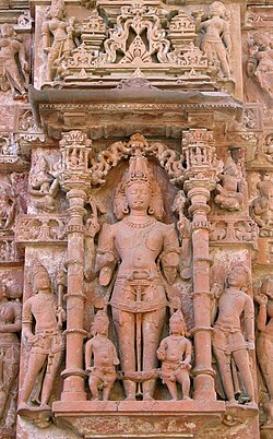
Surya Statue, Jhalrapatan in Jhalawar district, Rajasthan, India
Nickname: 
City of Bells
India Rajasthan location map.svg
Red pog.svg
Jhalrapatan
Location in Rajasthan, India
India location map.svg
Red pog.svg
Jhalrapatan
Jhalrapatan (India)
Coordinates: 24°33′N76°10′E / 24.55°N 76.17°E / 24.55; 76.17
Country Flag of India.svg  India
State Rajasthan
District Jhalawar
Founded by Zalim Singh
Named for bells(jhalar) sound
Government
  TypeMunicipality
Elevation
317 m (1,040 ft)
Population
 (2011)
  Total37,506
Languages
  Official Hindi, Rajasthani, Hadoti
  NativeHadoti dialect
Time zone UTC+5:30 (IST)
PIN
326023(common)

Jhalrapatan is a city and municipality of India in Jhalawar district in the state of Rajasthan. Its population is approximately 37,506.[ citation needed ]

Contents

A municipality was established at Jhalrapatan in 1892. [1]

History

Jhalrapatan was founded in 1796 by Zalim Singh, [2] approximately half a mile north of the ruins of Chandravati, which had been destroyed by Aurangzeb. [3]

Education

Schools in Jhalrapatan include

Government Engineering College, Jhalawar •Government Higher Secondary School •Government Girls Higher Secondary School •Vasudha Sr. Secondary School •Dr Radhakrishanan Sr Sec School •Gyan Ganga Public School

Geography

Jhalrapatan is located at 24°33′N76°10′E / 24.55°N 76.17°E / 24.55; 76.17 . It has an average elevation of 317 metres (1040 feet).

Demographics

As of the 2001 India census, [4] Jhalrapatan had a population of 30,103. Males constitute 52% of the population and females 48%. Jhalrapatan has an average literacy rate of 69%, higher than the national average of 59.5%: male literacy is 77%, and female literacy is 60%. 16% of the population is under 6 years of age.

Related Research Articles

<span class="mw-page-title-main">Jhalawar</span> City in Rajasthan, India

Jhalawar ( ) is a city, municipal council and headquarter in Jhalawar district of the Indian state of Rajasthan. It is located in the southeastern part of the state. It was the capital of the former princely state of Jhalawar, and is the administrative Jhalawar district. Its district headquarters is Jhalawar. This district is the 22nd largest district of Rajasthan. This district is known by the nicknames of Cherrapunji of Rajasthan, Nagpur of Rajasthan, Brijnagar of Rajasthan etc. Cherrapunji of rajasthan because the highest rainfall in the whole of Rajasthan occurs in manoharthana town in this district. Gagron fort at the confluence of Kalisindh and Ahu river at some distance from Jhalawar It is situated which is one of the Jaldurg of Rajasthan and it is such a fort which is a standing fort without foundation. This fort was included in the UNESCO World Heritage List in 2013.

<span class="mw-page-title-main">Jhalawar district</span> District of Rajasthan in India

Jhalawar district is one of the 33 districts of Rajasthan state in western India. The historical city of Jhalawar is the administrative headquarters of the Jhalawar district. The district is bounded on the northwest by Kota district, on the northeast by Baran district, on the east by Guna district of Madhya Pradesh state, on the south by Rajgarh district and Agar Malwa district of Madhya Pradesh state and on the west by Ratlam district and Mandsaur district of Madhya Pradesh state. The district occupies an area of 6219 km². The district is part of Kota division. To know more about Jhalawar City

Kushalgarh is a town and municipality in the Indian state of Rajasthan. It is located in the Banswara District approximately 65 km south of the city of Banswara. King Kushala Bhil was founder of Kushalgarh

Aklera is a town and an Indian municipality in Jhalawar district in the state of Rajasthan. It is in the south-eastern region of Rajasthan at the edge of the Malwa plateau and has a rocky, scrub-covered terrain.

Bakani is a census town in Jhalawar district in the state of Rajasthan, India. Bakani is 42 kilometres (26 mi) from its district headquarters, Jhalawar.

Bhawani Mandi is a town and a municipality in Jhalawar district in the state of Rajasthan, India.

Chhabra is a city and a municipality in Baran district in the state of Rajasthan, India, near to the border with Madhya Pradesh. Chhabra is a historic walled city with a fort. Its name comes from the six gates in the walls.

Garoth is a town in Madhya Pradesh state in central India. It is one of the tehsil of Mandsaur District.It shares boundary with Jhalawar district of Rajasthan.The local Language or dialect spoken here is a mixture of Mewari, Harauti and Malwi Languages.Latitude and longitude coordinates are: 24.328077, 75.649902.

Karera is a municipality or Nagar Parishad in the Shivpuri district of the Indian state of Madhya Pradesh.

Kolvi Mandi Rajendra pura is a census town in Jhalawar district in the Indian state of Rajasthan.

Manohar Thana is a census town in Jhalawar district in the Indian state of Rajasthan.

Modak is a census town in Kota district in the Indian state of Rajasthan. Modak is in Ramganjmandi Tehsil. It is located 61 km south of Kota, the district headquarters.

Pirawa is a city and a municipality in Jhalawar district in the India.

<span class="mw-page-title-main">Sadri</span> City in Rajasthan, India

Sadri is a municipality in the Pali district of Rajasthan, India. It is considered the gateway to Marwar from Mewar. Sadri is one of the main places of worship for the Jain community. Ranakpur Temple and Shri Parshuram Mahadev Mandir are located in Sadri, which became a municipality in 1961. Bhadras is located 3 km from Sadri along the Suhai river.

Sangod is a city and a municipality in Kota district in the Indian state of Rajasthan.Sangod is also a Legislative Assembly heeralal naagar is the Member of Legislative Assembly (MLA) from Sangod. Current SHO of sangod police station is Bharat Singh. Devki Nandan Rathore is Chairman of Municipal Corporation of Sangod.and the City sangod is named upon sanga gurjar who defeated meens and jaats and name this city upon his name sangod for his victory

Singoli is a block and a nagar panchayat in Neemuch district in the Indian state of Madhya Pradesh.

Sunel is a Town in Jhalawar district, Rajasthan, India, with a population of about 25000. It was formerly known as Ahilya Nagri. The Ahu River is 3 kilometres (2 mi) from Sunel.

<span class="mw-page-title-main">Jhalrapatan Assembly constituency</span> Legislative Assembly constituency in Rajasthan State, India

Jhalrapatan is one of the 200 Legislative Assembly constituencies of Rajasthan state in India. It is in Jhalawar district and is a segment of Jhalawar–Baran.

Nanagwas is a small village located in Neemrana Tehsil of Kotputali Bheror District, Rajasthan, India.

Asnawar is a small town in Jhalawar district, Rajasthan, India, with a population of about 15,000. It was formerly known as Aasnaver. The Kalisindh River is 8 kilometres (5 mi) from Asnawar. Also famous temples like rata devi, kham kheda, modi ki jahar.

References

  1. Rima Hooja (2006). A History of Rajasthan. Rupa. p. 1166. ISBN   9788129108906.
  2. The Encyclopaedia Britannica: Italy-Kyshtym. At the University Press. 1911. p. 412.
  3. DHOUNDIYAL, B. N. (1964). Rajasthan District Gazetteer of Jhalawar. GOVERNMENT CENTRAL PRESS, Jaipur. pp. 286–289.
  4. "Rajasthsan" (PDF). Census of India. 2001. Retrieved 19 April 2010.