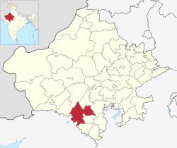
Udaipur district

Last updated

Udaipur district
India-7192 - Flickr - archer10 (Dennis).jpg
Jaisamand lake.jpg
Jagdish Temple - escalier d'entree.jpg
India-6956 - Flickr - archer10 (Dennis).jpg
Udaipur, India, Hilly landscape.jpg
Clockwise from top-left: View of Udaipur from City Palace, Jaisamand Lake, Ghats at Udaipur, Aravalli Hills, Jagdhish Temple
Udaipur in Rajasthan (India).svg
Location of Udaipur district in Rajasthan
Coordinates(Udaipur): 24°23′N73°37′E / 24.383°N 73.617°E / 24.383; 73.617
CountryFlag of India.svg  India
State Rajasthan
Division Udaipur
Headquarters Udaipur
Tehsils 1.Badgaon 2.Bhindar 3.Girwa 4.Gogunda 5.Jhadol 6.Kanor 7.Kherwara 8.Kotra 9.Lasadiya 10.Mavli 11.Rishabhdeo 12.Salumbar 13.Semari 14.Sarada 15.Vallabhnagar
Government
   Lok Sabha constituencies District spread over 2 constituencies - Udaipur and Chittorgarh
   Vidhan Sabha constituencies 9
Area
  Total11,724 km2 (4,527 sq mi)
Population
 (2011) [1]
  Total3,068,420
  Density260/km2 (680/sq mi)
   Urban
19.83%
Demographics
   Literacy 61.82% [2]
  Sex ratio958
Languages
  Official Hindi
  Regional Mewari
Time zone UTC+05:30 (IST)
Major highways National Highways 8, 76
Average annual precipitation554 mm
Website udaipur.rajasthan.gov.in

Udaipur district is one of the 52 districts of Rajasthan state in western India. [3] The historic city of Udaipur is the administrative headquarters of the district. [2] The district is part of the Mewar region of Rajasthan. [4]

Contents

History

Before Udaipur district was established in independent India, it was a part of former Mewar or Udaipur State, [2] comprising little less than half the portion of the former state. [4]

With the formation of the United State of Rajasthan in 1948, parts of the erstwhile district of Girwa, Khamnor, Rajnagar, Bhim, Magra, Kherwara and Kumbhalgarh, together with the thikanas of Nathdwara, Kankroli, Salumbar (excluding Sayra tehsil), Bhinder, Kanor, Bansi, Bari Sadri, Amet, Sardargarh, Deogarh and Gogunda were combined to constitute the district of Udaipur. [2]

During the decadal period 1951–61, two new tehsils – Nathdwara and Gogunda – were created in the district. [4] In 1991, seven tehsils of Udaipur district (Bhim, Deogarh, Amet, Kumbhalgarh, Rajsamand, Nathdwara and Railmagra) were transferred out of Udaipur district to create the new district of Rajsamand. [2] Since then, several new tehsils have been created by restructuring or dividing existing tehsils; such new tehsils include Rishabhdeo and Lasadiya created in 2008, [2] Badgaon in 2012, [5] Bhindar in 2017, [6] and Kanor in 2018. [7]

Geography

Map of Udaipur district Udaipur district map.jpg
Map of Udaipur district

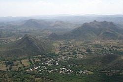
The area of Udaipur District is 11,724 square kilometres. [8] The district is characterized by hilly terrain, with hills in the west and south, an elevated plateau in the north, and plains in the east. [4] [9] The western part of the district is drained by the Sabarmati, Wakal and Sei rivers, while the southeastern part of the district is drained by Jakham, Gomti and Som rivers. [9]

Udaipur district bounded on the northwest by the Aravalli Range, across which lie the districts of Sirohi and Pali. [10] It is bounded on the north by Rajsamand District, on the east by Chittaurgarh District and Pratapgarh District, on the south by Dungarpur District, and on the southwest by the state of Gujarat. [10] The continental watershed, in the form of the Aravalli range, passes through the district, with the northeastern part of the district draining to the Bay of Bengal and the southwestern part draining to the Gulf of Khambhat. [11] 47% of the district's area lies in the Mahi basin, 30% in Sabarmati basin, and 23% in the Banas basin. [11] The average annual rainfall of the district is 637 mm. [9]

Demographics

Historical population
YearPop.±% p.a.
1901347,896    
1911430,225+2.15%
1921456,868+0.60%
1931522,826+1.36%
1941623,505+1.78%
1951733,014+1.63%
1961909,566+2.18%
19711,185,788+2.69%
19811,574,876+2.88%
19911,952,388+2.17%
20012,481,201+2.43%
20113,068,420+2.15%
source: [12]
Religions in Udaipur district (2011) [13]
ReligionPercent
Hinduism
93.53%
Islam
3.40%
Jainism
2.56%
Other or not stated
0.51%

According to the 2011 census Udaipur district has a population of 3,068,420, [1] roughly equal to the nation of Oman [14] or the US state of Iowa. [15] This gives it a ranking of 118th in India (out of a total of 640). [1] The district has a population density of 242 inhabitants per square kilometre (630/sq mi) . [1] Its population growth rate over the decade 2001-2011 was 23.66%. [1] Udaipur has a sex ratio of 958 females for every 1000 males, [1] and a literacy rate of 62.74%. 19.83% of the population lives in urban areas. Scheduled Castes and Scheduled Tribes make up 6.14% and 49.71% of the population respectively. [1]

Several areas of the district are classified as Scheduled Areas because of large tribal populations in these areas. [16] In rural areas, tribals are 60.29% of the population. [1] Scheduled Areas in the district include the entire tehsils of Kotra, Jhadol, Lasadiya, Salumbar, Sarada, Kherwara, Rishabhdeo, and Gogunda, and portions of Girwa, Mavli, and Vallabhnagar tehsils. [16] Among 2,479 villages in the district, 1,945 villages (78%) are designed as being under the Tribal Sub-Plan. [17]

Languages

Languages in Udaipur district (2011) [18]

   Mewari (44.19%)
   Wagdi (27.00%)
   Hindi (13.12%)
   Rajasthani (12.05%)
  Others (3.64%)

At the time of the 2011 census, 44.19% of the population spoke Mewari, 27.00% Wagdi, 13.12% Hindi and 12.05% Rajasthani as their first language. [18]

Administrative Structure

Udaipur district comprises Fifteen sub-divisions: Sarada, Girwa, Gogunda, Badgaon, Kherwara, Bhinder, Lasadiya, Mavli, Vallabhnagar, Kotra, Jhadol, Rishabhdev and Salumbar. [19] These sub-divisions are further divided into 18 tehsils. [20] Girwa sub-division consists two tehsils: Girwa and Gogunda. [2] Kherwada sub-division also comprises two tehsils: Kherwada and Rishabhdeo. [2] Each of the sub-divisions, Mavli, Vallabhnagar, Kotda and Jhadol comprise only one tehsil of the same name. [2] Salumbar sub-division comprises three tehsils: Lasadiya, Salumbar and Sarada. [2] There are 20 Panchayat Samitis in the district. [19]

Economy

The economy of Udaipur district is primarily dependent on agriculture with 61.7 percent workers in the district engaged as cultivators or agricultural labourers. [2]

In 2006 the Ministry of Panchayati Raj named Udaipur one of the country's 250 most backward districts (out of a total of 640). [21] It is one of the twelve districts in Rajasthan currently receiving funds from the Backward Regions Grant Fund Programme (BRGF). [21]

Udaipur district is rich in mineral resources, and produces greater value of minerals than the rest of the state combined. [2] The important metallic minerals found in the district are ore of copper, lead, zinc and silver. [2] Important non-metallic minerals found in the district are rock phosphate, asbestos, limestone, and marble. [22]

See also

Related Research Articles

Gogunda is a town and tehsil headquarters of Gogunda Tehsil in Udaipur district, located about 35 km (22 mi) in north-west from Udaipur city in the Indian state of Rajasthan. It is situated on a high mountain in Aravalli hills and is reached by crossing a difficult mountain pass.

<span class="mw-page-title-main">Rajsamand district</span> District of Rajasthan in India

Rajsamand District is a district of the state of Rajasthan in western India. The city of Rajsamand is the district headquarters. The district was constituted on 10 April 1991 from Udaipur district by carving out 7 tehsils - Bhim, Deogarh, Amet, Kumbhalgarh, Rajsamand, Nathdwara, and Railmagra.

Jhadol (Jharol) is a village in Jhadol Tehsil in Udaipur district in the Indian state of Rajasthan. As of the 2001 census, it had a population of 4,753 in 988 households.

Badgaon or Bargaon may refer to the following places in India:

Badgaon is a village in Mavli tehsil of Udaipur district in the Indian state of Rajasthan.

Girwa is a tehsil of Udaipur district, Rajasthan, India. The administrative headquarter of the tehsil is located in the City of Udaipur.

<span class="mw-page-title-main">Kotra tehsil</span> Tehsil in Udaipur, Rajasthan, India

Kotra is a tehsil of Udaipur district in Rajasthan, India, consisting of 262 revenue villages and 31 panchayats. The tehsil is bordered to the north by Pali and Sirohi districts, to the east by Gogunda and Jhadol tehsils, and to the south by Gujarat state. The tehsil headquarter is located in the village of Kotra, southwest of the Udaipur at a distance of 57 km and 120 km by road.

Bedla is a census town in the Bargaon tehsil of Udaipur district, Rajasthan, India. It is situated near Sukher area, on the Udaipur-Nathdwara highway, around 8 km (5.0 mi) from the city center and around 387 km (240 mi) from state capital Jaipur. Nearby Bedla, there is Udaipur Tehsil towards South, Gogunda Tehsil towards west, Khamnor Tehsil towards North and Mavli Tehsil towards East.

Bargaon is a census town in the Girwa tehsil of Udaipur district, Rajasthan, India. It is situated on the Udaipur-Gogunda highway, around 4 kilometres (2.5 mi) from the city centre, 2 kilometres (1.2 mi) from Bhuwana and around 387 kilometres (240 mi) from the state capital at Jaipur. It has Dungla Tehsil towards East, Bhopalsagar Tehsil towards North, Mavli Tehsil towards North and Bhadesar Tehsil towards East.

Semari is a tehsil of Salumbar district in Rajasthan, India. The administrative headquarter of the tehsil is located in the town of Semari.

<span class="mw-page-title-main">Jhadol tehsil</span> Tehsil in Udaipur, Rajasthan, India

Jhadol tehsil is an administrative sub-division of Udaipur district in Rajasthan, India. Jhadol tehsil was formerly called Phalasia tehsil. The tehsil consists of 283 revenue villages and 45 panchayats. The tehsil headquarter is located in the village of Jhadol, southwest of the district headquarters, Udaipur.

<span class="mw-page-title-main">Gogunda tehsil</span> Tehsil in Udaipur, Rajasthan, India

Gogunda is a tehsil of Udaipur district in Rajasthan, India. The tehsil consists of 232 revenue villages, 45 panchayats, and 1 census town. The tehsil headquarter is located in the town of Gogunda.

<span class="mw-page-title-main">Kherwara tehsil</span> Tehsil in Udaipur, Rajasthan, India

Kherwara is a tehsil of Udaipur district in Rajasthan, India. The tehsil consists of 195 revenue villages and 1 census town. The tehsil headquarter is located in the town of Kherwara Chhaoni. The tehsil is part of the Kherwara panchayat samiti (block).

<span class="mw-page-title-main">Lasadiya tehsil</span> Tehsil in Udaipur, Rajasthan, India

Lasadiya is a tehsil of Udaipur district in Rajasthan, India.The tehsil consists of 114 revenue villages which are organized in 19 gram panchayats The tehsil headquarter is located in the village of Lasadiya. The boundaries of Lasadiya tehsil are conterminous with those of Lasadiya panchayat samiti.

<span class="mw-page-title-main">Mavli tehsil</span> Tehsil in Udaipur, Rajasthan

Mavli is a tehsil of Udaipur district in Rajasthan, India.The tehsil consists of 179 revenue villages which are organized in 42 gram panchayats and one town (Mavli). The tehsil headquarter is located in the town of Mavli. The boundaries of Mavli tehsil are conterminous with those of Mavli panchayat samiti.

Badgaon is a tehsil in Udaipur district of Rajasthan, India.

Bhindar is a tehsil of Udaipur district in Rajasthan, India. The tehsil headquarter is located in the town of Bhinder.

Kanor is a tehsil of Udaipur district in Rajasthan, India. As of April 2019, it is the 15th tehsil of Udaipur district and the youngest one, having been formed in 2018.

Vallabhnagar is a tehsil of Udaipur district in Rajasthan, India.

<span class="mw-page-title-main">Rishabhdeo tehsil</span> Tehsil in Udaipur, Rajasthan, India

Rishabhdeo is a tehsil of Udaipur district in Rajasthan, India.The tehsil consists of 125 revenue villages and one town. The tehsil headquarter is located in the town of Rishabhdeo.

References

  1. 1 2 3 4 5 6 7 8 "District Census Handbook 2011 - Udaipur" (PDF). Census of India . Registrar General and Census Commissioner of India.
  2. 1 2 3 4 5 6 7 8 9 10 11 12 13 District Census Handbook Udaipur, Village and Town Directory Part XII-A. Series-09, Part XII-A. Directorate of Census Operations Rajasthan. 2011.
  3. "Statistical Data of Rajasthan State Pertaining to Census-2011". www.rajcensus.gov.in. Retrieved 7 September 2018.
  4. 1 2 3 4 Agarwal, B.D. (1979). Rajasthan District Gazeteers Udaipur. Jaipur: Directorate of District Gazeteers.
  5. "Badgaon bani tehsil". Udaipur News. 18 June 2012. Retrieved 18 April 2019.
  6. "Saat jilo mein nau nai tehsilo ka gathan". Dainik Bhaskar. 8 November 2017. Retrieved 18 April 2019.
  7. "Notification No. P9(1) Raj / Group -1 / 2018". Revenue Board. Government of Rajasthan. 16 July 2018. Retrieved 18 April 2019.
  8. जिला एक दृष्टी मैं, जिला उदयपुर (District at a Glance, Udaipur District) (PDF). Udaipur: Office of Deputy Director Economic and Statistics. 2016.
  9. 1 2 3 Ground Water Scenario, Udaipur District, Rajasthan (PDF). Jaipur: Central Ground Water Board. 2013.
  10. 1 2 "Rajasthan Administrative Divisions 2011" (PDF). Census of India. Retrieved 7 September 2018.
  11. 1 2 Study on Planning of Water Resources of Rajasthan. Tahal Group. 2014. Retrieved 24 May 2019.
  12. Decadal Variation In Population Since 1901
  13. "Table C-01 Population By Religion - Rajasthan". census.gov.in. Registrar General and Census Commissioner of India.
  14. US Directorate of Intelligence. "Country Comparison:Population". Archived from the original on 13 June 2007. Retrieved 1 October 2011. Oman 3,027,959
  15. "2010 Resident Population Data". U. S. Census Bureau. Retrieved 30 September 2011. Iowa 3,046,355
  16. 1 2 "Gazette of India". Government of India. 19 May 2019. Retrieved 13 April 2019.
  17. "TSP mein jude Udaipur ke 342 gaon, pahle 1612 the, ab 1954 hue". Dainik Bhaskar. 12 July 2018. Retrieved 20 April 2019.
  18. 1 2 "Table C-16 Population by Mother Tongue: Rajasthan". censusindia.gov.in. Registrar General and Census Commissioner of India.
  19. 1 2 "Udaipur District". udaipur.rajasthan.gov.in. Retrieved 27 February 2022.
  20. "Telephone Directory". Official Website of Udaipur. Retrieved 18 April 2019.
  21. 1 2 Ministry of Panchayati Raj (8 September 2009). "A Note on the Backward Regions Grant Fund Programme" (PDF). National Institute of Rural Development. Archived from the original (PDF) on 5 April 2012. Retrieved 27 September 2011.
  22. "Brief Industrial Profile of Udaipur District" (PDF). Dcmsme.gov.in. Government of India - Ministry of MSME. Retrieved 21 July 2015.