Kotra tehsil

Last updated

Kotra tehsil
कोटड़ा तहसील
Tehsil
Map of Kotra tehsil from Census of India 2011.jpg
Kotra tehsil
India Rajasthan location map.svg
Red pog.svg
Kotra tehsil
Location of Jhadol tehsil
India location map.svg
Red pog.svg
Kotra tehsil
Kotra tehsil (India)
Coordinates: 24°27′21″N73°12′29″E / 24.455754°N 73.208047°E / 24.455754; 73.208047
TehsilKotra
Area
[1]
  Total1,110 km2 (430 sq mi)
Population
 (2011) [1]
  Total230,532
  Density210/km2 (540/sq mi)
Time zone Indian Standard Time

Kotra (also spelt Kotda) is a tehsil of Udaipur district in Rajasthan, India, [2] consisting of 262 revenue villages and 31 panchayats. [1] The tehsil is bordered to the north by Pali and Sirohi districts, to the east by Gogunda and Jhadol tehsils, and to the south by Gujarat state. The tehsil headquarter is located in the village of Kotra, [3] southwest of the Udaipur at a distance of 57 km and 120 km by road.

Contents

History

In the erstwhile Mewar State, present-day Kotra tehsil was part of the Kotra Bhumat (also spelt Bhumiat), [4] an area comprising 242 villages. [5] Bhumat was characterized by a system of land tenure under which petty chieftains held tenure known as bhum (spelt as bhom in certain sources). [6] [7] The Kotra Bhumat was administered by the chieftains of Jura, Oghna, and Panarva, who paid a small tribute to the Mewar Durbar and were liable to be called on for local service. [7] [4] The Kotra Bhumat could be distinguished from other parts of Mewar by the fact that "the Bhils [there] were never conquered: even the jagirdars (were) of Bhil ancestry." [6]

During the British Raj, Kotra was directly under the political supervision of the second in command of the Mewar Bhil Corps and a cantonment was situated in the village of Kotra. [5] The 1908 Imperial Gazetteer describes Kotra as a cantonment where a detachment (two companies) is quartered. [4] Kotra was the site of the oldest medical institutions in the Mewar State, when regimental hospitals of the Mewar Bhil Corps were opened in 1818. [5]

In 1949, Udaipur State merged into Greater Rajasthan, and Udaipur district was formed with 18 tehsils, of which Kotra was one. [5] The Kotra panchayat samiti started functioning in 1959. [5] Between the census of 2001 and 2011, approximately 60 villages in the northeastern portion of the tehsil were reassigned to Gogunda and Jhadol tehsils. [1] :134–153

Whereas revenue settlement begun in some parts of Udaipur district in 1879, but it was not until 1955 that Kotra tehsil was settled, when 304 villages were settled. [5]

Geography

The area of Kotra tehsil is 1,110.93 square kilometres. [1] The annual average rainfall in Kotra tehsil is 800.7 mm, with an average of 35 rainy days per year. [8]

Terrain of Kotra Tehsil Elevations in Kotra Tehsil.jpg
Terrain of Kotra Tehsil

Ground elevations in the tehsil range from 187 m (above Mean Sea Level) to 1,017 m. Elevations in the northern and eastern parts of the tehsil are generally higher, sloping down in a southwesterly direction towards the Sabarmati River and its tributaries.

Rivers of Kotra Tehsil Rivers of Kotra tehsil, Udaipur district, Rajasthan, India.jpg
Rivers of Kotra Tehsil

Major rivers in Kotra are Sei, Sabarmati, Pamri, Wakal, Divav and Kosambi. [9] The general direction of the rivers is north to south. The Sei Dam is located on the Sei River in northern Kotra tehsil near the village of Teja ka Bas. [10] This is a 28 m high dam which is used to impound water not for use downstream of the dam, but for inter-basin transfer to Jawai dam in neighbouring Pali district. [11] [12]

The Phulwari ki Nal Wildlife Sanctuary is partially situated in Kotra tehsil. [13]

Economy

Economic activities and livelihood opportunities in Kotra tehsil are limited; this has been attributed to small land holdings, poor quality of natural resources, lack of irrigation, and low literacy levels. [14] Thus, the economy of Kotra depends heavily on migration. [15] A 2006 survey found that at least one member from nearly half of Kotra households (49.2%) leave the tehsil to seek employment. [14] The chief destination for Kotra emigrants is the state of Gujarat (66% of workers), most of which is in the northern Gujarat districts of Banaskantha and Sabarkantha. [14] Migrants from the Kotra block are generally employed in unskilled employment with about 83% of them employed as unskilled laborers in agriculture and construction sectors. [14]

Transport

Primary Roads of Kotra Tehsil Primary Roads of Kotra Tehsil.jpg
Primary Roads of Kotra Tehsil

Roads are the only mode of long-distance transport in Kotra tehsil. There is limited bus service available from Udaipur to Kotra by Rajasthan State Road Transport Corporation (RSRTC). [16] In addition to RSRTC bus service, the tehsil is served by private taxi operators. [16] The tehsil is not served by air or rail transportation.

Demographics

Population

As of the 2011 India census, Kotda had a population of 230,532 (116,764 males and 113,768 females). [17] The total number of households was 41,790. [1] Males constitute 50.65 percent of the population and females make up 49.35 percent. Kotra has an average literacy rate of 24.52 percent, lower than the national average of 59.5 percent (2001 census); male literacy is 37.55 percent, and female literacy is 11.14 percent. In Kotra, for every 1,000 males there are 980 females. This sex ratio is favorable against the state's sex ratio of 922.

Tribal population

Kotra is a tribal-dominant tehsil with 220,905 persons (95.82% of population) belonging to Scheduled Tribes. [1] Because of the large proportion of tribals in its population, Kotra tehsil in its entirety is included in the Tribal sub-plan. [18] For the same reason, Kotra tehsil has been designated as a scheduled area which allows special protection of tribal culture and other interests. [19]

Language

As per the 2001 Census of India, 90% of the population of Kotra tehsil speaks Mewari. [20] However, GS Ojha reports that whereas Mewari is the primary language of the Mewar region, the language spoken in the southern and western parts of Mewar (which includes Kotra) is Vagdi. Ojha describes Vagdi as being related to Gujarati. [21]

Related Research Articles

Banswara is a town in the Banswara district in southern Rajasthan, India. The name, Banswara, came from king ‘Bansiya Bhil’

<span class="mw-page-title-main">Rajgarh district</span> District of Madhya Pradesh in India

Rajgarh district is a district of Madhya Pradesh in central India. The city of Rajgarh is the administrative headquarters of the district. The old name of Rajgarh was Jhanjhanipur. Rajgarh in Madhya Pradesh is one of the aspirational districts selected by Government of India. The district has an area of 6,154 km² and the population is 1,545,814. The district lies on the northern edge of the Malwa plateau, and the Parbati River forms the eastern boundary of the district, while the Kali Sindh River forms the western boundary. The district has seven tehsils, Rajgarh, Khilchipur, Jirapur, Biaora, Narsinghgarh, Sarangpur and Pachore. The district is bounded by Rajasthan state to the north, and by the districts of Guna to the northeast, Bhopal to the east, Sehore to the southeast, and Shajapur to the south and west. It is part of Bhopal Division. There are 1728 villages in Rajgarh.

<span class="mw-page-title-main">Udaipur district</span> District of Rajasthan in India

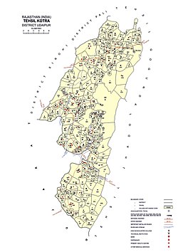
Udaipur district is one of the 50 districts of Rajasthan state in western India. The historic city of Udaipur is the administrative headquarters of the district. The district is part of the Mewar region of Rajasthan.

Gogunda is a town and tehsil headquarters of Gogunda Tehsil in Udaipur district, located about 35 km (22 mi) in north-west from Udaipur city in the Indian state of Rajasthan. It is situated on a high mountain in Aravalli hills and is reached by crossing a difficult mountain pass.

<span class="mw-page-title-main">Dungarpur district</span> District of Rajasthan in India

Dungarpur District is a district of the state of Rajasthan in western India. The town of Dungarpur is the district headquarters.

<span class="mw-page-title-main">Pali district</span> District of Rajasthan in India

Pali district is a district in Rajasthan, India. The city of Pali is its administrative headquarters. Pali is also known as the Industrial/Textile City and has been a hub for merchant activities for centuries. It has a rich heritage and culture, including beautiful Jain temples and other elaborate monuments.

<span class="mw-page-title-main">Udaipur</span> City in Rajasthan, India

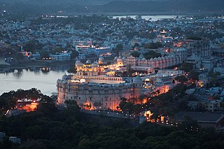
Udaipur is a city and municipal corporation in Udaipur district of the state of Rajasthan, India. It is also known as the 'City of Lakes' and serves as the administrative headquarters of Udaipur district. It is the historic capital of the kingdom of Mewar in the former Rajputana Agency. It was founded in 1559 by Udai Singh II of the Sisodia clan of Rajputs, when he shifted his capital from the city of Chittorgarh to Udaipur after Chittorgarh was besieged by Akbar. It remained as the capital city till 1818 when it became a British princely state, and thereafter the Mewar province became a part of Rajasthan when India gained independence in 1947.

Kherwara Chhaoni is a census town in the Udaipur district in the Indian state of Rajasthan. It is part of the Vagad region, which includes the districts of Dungarpur, Banswara and parts of Udaipur district. It is in close proximity to two major highways, National Highway 8 and Rajasthan State Highway 76 and National Highway 927A passes through it. Its name derives from the large number of Kher (Khair) trees in the region in the past.

Rikhabdeo ( Rishabhadeo) is a town in Udaipur district in the state of Rajasthan, in north-west India.

<span class="mw-page-title-main">Pratapgarh district, Rajasthan</span> District of Rajasthan in India

Pratapgarh district is the 33rd district of Rajasthan, created on 26 January 2008. It is a part of Udaipur Division and has been carved out from the erstwhile tehsils of Chittorgarh, Udaipur and Banswara districts. Pratapgarh town is the administrative headquarters of the district.

<span class="mw-page-title-main">Motilal Tejawat</span> Indian activist

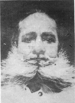
Motilal Tejawat , (1885–1963) was the leader of the Eki Movement that was agitated in the 1920s in the adivasi-dominated border areas of present-day Rajasthan and Gujarat.

Bhomat is a mountainous and forested area in southern Rajasthan, covering all or parts of the tehsils of Kotra, Jhadol and Kherwara in Udaipur district. During British rule, the region was also referred to as 'Hilly Tracts of Mewar'.

<span class="mw-page-title-main">Jhadol tehsil</span> Tehsil in Udaipur, Rajasthan, India

Jhadol tehsil is an administrative sub-division of Udaipur district in Rajasthan, India. Jhadol tehsil was formerly called Phalasia tehsil. The tehsil consists of 283 revenue villages and 45 panchayats. The tehsil headquarter is located in the village of Jhadol, southwest of the district headquarters, Udaipur.

<span class="mw-page-title-main">Mewar Bhil Corps</span> Military unit

The Mewar Bhil Corps is a state armed police force of the Rajasthan Police. The Corps was originally raised by the British Indian government as a military unit along similar lines as units such as the Merwara Battalion and Malwa Bhil Corps. The Corps operated as a regular unit of the British Indian Army until 1938; since then it has been maintained as a para-military force.

<span class="mw-page-title-main">Gogunda tehsil</span> Tehsil in Udaipur, Rajasthan, India

Gogunda is a tehsil of Udaipur district in Rajasthan, India. The tehsil consists of 232 revenue villages, 45 panchayats, and 1 census town. The tehsil headquarter is located in the town of Gogunda.

<span class="mw-page-title-main">Kherwara tehsil</span> Tehsil in Udaipur, Rajasthan, India

Kherwara is a tehsil of Udaipur district in Rajasthan, India. The tehsil consists of 195 revenue villages and 1 census town. The tehsil headquarter is located in the town of Kherwara Chhaoni. The tehsil is part of the Kherwara panchayat samiti (block).

<span class="mw-page-title-main">Mavli tehsil</span> Tehsil in Udaipur, Rajasthan

Mavli is a tehsil of Udaipur district in Rajasthan, India.The tehsil consists of 179 revenue villages which are organized in 42 gram panchayats and one town (Mavli). The tehsil headquarter is located in the town of Mavli. The boundaries of Mavli tehsil are conterminous with those of Mavli panchayat samiti.

Banswari is a village in Jhadol Tehsil in Udaipur district in the Indian state of Rajasthan. It is administrated by Sarpanch who is elected representative of village.

Majam is a village in Gogunda Tehsil in Udaipur district in the Indian state of Rajasthan. The District headquarter of the village is Udaipur.

Ogna, also Oghna, is a village in Jhadol tehsil, Udaipur district, Rajasthan, India. It is mostly dependent on agriculture.

References

  1. 1 2 3 4 5 6 7 District Census Handbook: Udaipur (PDF). Census of India. 2011. Archived (PDF) from the original on 14 November 2015. Retrieved 23 January 2017.
  2. "Official Website of Udaipur: Blocks/Tehsils/Panchayats". Government of Rajasthan. Archived from the original on 24 December 2016. Retrieved 23 January 2017.
  3. Administrative Atlas of Rajasthan: District and Tahsil (PDF). Census of India. 2011. p. 663. Archived (PDF) from the original on 13 November 2014. Retrieved 24 January 2017.
  4. 1 2 3 The Imperial Gazetteer of India, Volume XVI (PDF). Oxford. 1908. p. 4. Archived (PDF) from the original on 2 February 2017. Retrieved 28 January 2017.
  5. 1 2 3 4 5 6 Agarwal, B.D. (1979). Rajasthan District Gazeteers: Udaipur. Jaipur: Government of Rajasthan. p. 592. Archived from the original on 2 February 2017. Retrieved 27 January 2017.
  6. 1 2 Carstairs, G Morris (1952). "Bhil Villages of Western Udaipur: A Study in Resistance To Social Change" (PDF). The Economic Weekly. 1 March 1952: 231. Archived (PDF) from the original on 2 February 2017. Retrieved 28 January 2017.
  7. 1 2 Rajasthan Through the Ages, Volume 5: Marwar and British Administration. New Delhi, India: Sarup & Sons. 2008. p. 164. ISBN   978-81-7625-841-8.
  8. Singh, O.P.; et al. (2013). Rainfall Profile of Udaipur (PDF). Meteorological Monograph: Hydrology No.15/2013. New Delhi: India Meteorological Department. p. 108. Archived (PDF) from the original on 13 July 2018. Retrieved 23 April 2019.
  9. Ranade, Rahul (2022). "Use of Cartosat-1 elevation data for local-scale terrain studies in India: a case study". International Journal of Cartography. 9: 87–96. doi:10.1080/23729333.2021.2024649. S2CID   248165588.
  10. Jain; Agarwal; Singh (2007). Hydrology and Water Resources of India. Dordrecht, The Netherlands: Springer. p. 583. ISBN   978-1-4020-5179-1. Archived from the original on 15 February 2017. Retrieved 23 April 2019.
  11. "Sei Diversion Dam". Water Resources Information System of India. Government of India. 27 January 2012. Archived from the original on 2 February 2017. Retrieved 30 January 2017.
  12. "Rajasthan Agriculture". Data India: 722. 1–7 January 1977.
  13. Banu, Farahat; Sharma, Satish Kumar (2017). "Flora of Various "Nals" of Phulwari Wild Life Sanctuary, Udaipur, Rajasthan" (PDF). Indian Journal of Environmental Sciences. 21: 62–70. Archived (PDF) from the original on 10 September 2018. Retrieved 23 April 2019.
  14. 1 2 3 4 "Migration Block Profile: Kotra" (PDF). Udaipur, Rajasthan: Aajeevika Bureau and Kotra Adivasi Sansthan. 28 January 2017. Archived (PDF) from the original on 5 April 2017. Retrieved 28 January 2017.
  15. Deshingkar, Priya; Farrington, John (2009). Circular Migration and Multilocational Livelihood Strategies in Rural India. Oxford University Press. p. 121. ISBN   978-0-19-569922-7. Archived from the original on 16 February 2017. Retrieved 23 April 2019.
  16. 1 2 "कोटड़ा से उदयपुर के लिए बस नहीं, जो चल रही वो भी धक्का मार के". Dainik Bhaskar. 6 February 2017. Archived from the original on 13 February 2017. Retrieved 12 February 2017.
  17. "Census of India C.D. Block Wise Primary Census Abstract Data for State of Rajasthan". Census of India. Archived from the original on 22 February 2015. Retrieved 23 January 2017.
  18. "Mavli aur Vallabhnagar ke kuchh bhag ab TSP mein". Dainik Bhaskar. 26 April 2018. Retrieved 1 May 2019.
  19. "Gazette of India". Government of India. 19 May 2019. Retrieved 13 April 2019.
  20. "Census Digital Library". Census of India. 25 February 2017. Archived from the original on 15 March 2016.
  21. Ojha, Gaurishankar Hirachand (1999). उदयपुर राज्य का इतिहास, Vol 1. Jodhpur: Rajasthan Granthaghar. pp. 13–14. Archived from the original on 26 February 2017. Retrieved 23 April 2019.