
Rajasthan is a state in northern India. It covers 342,239 square kilometres (132,139 sq mi) or 10.4 per cent of India's total geographical area. It is the largest Indian state by area and the seventh largest by population. It is on India's northwestern side, where it comprises most of the wide and inhospitable Thar Desert and shares a border with the Pakistani provinces of Punjab to the northwest and Sindh to the west, along the Sutlej-Indus River valley. It is bordered by five other Indian states: Punjab to the north; Haryana and Uttar Pradesh to the northeast; Madhya Pradesh to the southeast; and Gujarat to the southwest. Its geographical location is 23°.3' to 30°.12' North latitude and 69°.30' to 78°.17' East longitude, with the Tropic of Cancer passing through its southernmost tip.

Udaipur district is one of the 52 districts of Rajasthan state in western India. The historic city of Udaipur is the administrative headquarters of the district. The district is part of the Mewar region of Rajasthan.
Sirohi District is a district of Rajasthan state in western India. The city of Sirohi is the district headquarters.
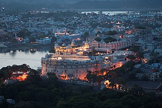
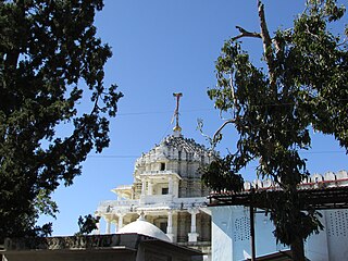
Udaipur is a city and municipal corporation in Udaipur district of the state of Rajasthan, India. it is also known as the ''City of Lakes''. It is the administrative headquarter of Udaipur district. It is the historic capital of the kingdom of Mewar in the former Rajputana Agency. It was founded in 1559 by Udai Singh II of the Sisodia clan of Rajputs, when he shifted his capital from the city of Chittorgarh to Udaipur after Chittorgarh was besieged by Akbar. It remained as the capital city till 1818 when it became a British princely state, and thereafter the Mewar province became a part of Rajasthan when India gained independence in 1947.
Jhadol (Jharol) is a village in Jhadol Tehsil in Udaipur district in the Indian state of Rajasthan. As of the 2001 census, it had a population of 4,753 in 988 households.
Girwa is a tehsil of Udaipur district, Rajasthan, India. The administrative headquarter of the tehsil is located in the City of Udaipur.

Kotra is a tehsil of Udaipur district in Rajasthan, India, consisting of 262 revenue villages and 31 panchayats. The tehsil is bordered to the north by Pali and Sirohi districts, to the east by Gogunda and Jhadol tehsils, and to the south by Gujarat state. The tehsil headquarter is located in the village of Kotra, southwest of the Udaipur at a distance of 57 km and 120 km by road.

Jhadol tehsil is an administrative sub-division of Udaipur district in Rajasthan, India. Jhadol tehsil was formerly called Phalasia tehsil. The tehsil consists of 283 revenue villages and 45 panchayats. The tehsil headquarter is located in the village of Jhadol, southwest of the district headquarters, Udaipur.

Gogunda is a tehsil of Udaipur district in Rajasthan, India. The tehsil consists of 232 revenue villages, 45 panchayats, and 1 census town. The tehsil headquarter is located in the town of Gogunda.

Kherwara is a tehsil of Udaipur district in Rajasthan, India. The tehsil consists of 195 revenue villages and 1 census town. The tehsil headquarter is located in the town of Kherwara Chhaoni. The tehsil is part of the Kherwara panchayat samiti (block).

Lasadiya is a tehsil of Salumbar district in Rajasthan, India.The tehsil consists of 114 revenue villages which are organized in 19 gram panchayats The tehsil headquarter is located in the village of Lasadiya. The boundaries of Lasadiya tehsil are conterminous with those of Lasadiya panchayat samiti.

Mavli is a tehsil of Udaipur district in Rajasthan, India.The tehsil consists of 179 revenue villages which are organized in 42 gram panchayats and one town (Mavli). The tehsil headquarter is located in the town of Mavli. The boundaries of Mavli tehsil are conterminous with those of Mavli panchayat samiti.
Badgaon is a tehsil in Udaipur district of Rajasthan, India.
Bhindar is a tehsil of Udaipur district in Rajasthan, India. The tehsil headquarter is located in the town of Bhinder.
Kanor is a tehsil of Udaipur district in Rajasthan, India. As of April 2019, it is the 15th tehsil of Udaipur district and the youngest one, having been formed in 2018.
Vallabhnagar is a tehsil of Udaipur district in Rajasthan, India.

Salumbar is a tehsil of Salumbar district in Rajasthan, India.The tehsil consists of 268 revenue villages which are organized in 46 gram panchayats and one town. The tehsil headquarter is located in the town of Salumbar.

Rishabhdeo is a tehsil of Udaipur district in Rajasthan, India.The tehsil consists of 125 revenue villages and one town. The tehsil headquarter is located in the town of Rishabhdeo.
Sarada is a tehsil of Salumbar district in Rajasthan, India. It consists of 152 villages and 3 towns. The tehsil headquarter is located in the village of Sarada.
Ajmer is a tehsil in Ajmer district of Rajasthan state in India. It consists of 4 census towns and 85 villages. The capital of the tehsil is the eponymous Ajmer.

