Lasadiya tehsil

Last updated

Lasadiya tehsil
Tehsil
Map of Lasadiya tehsil from Census of India 2011.png
Lasadiya tehsil
India Rajasthan location map.svg
Red pog.svg
Lasadiya tehsil
Location of Lasadiya tehsil
India location map.svg
Red pog.svg
Lasadiya tehsil
Lasadiya tehsil
(India)
Coordinates: 24°14′36″N74°13′50″E / 24.243362°N 74.230635°E / 24.243362; 74.230635
Tehsil seatLasadiya
Area
  Total539 km2 (208 sq mi)
  [1]
Population
 (2011)
  Total91,229 [1]
Time zone Indian Standard Time

Lasadiya (also spelt Lasadia [2] ) is a tehsil of Salumbar district in Rajasthan, India.The tehsil consists of 114 revenue villages which are organized in 19 gram panchayats [1] The tehsil headquarter is located in the village of Lasadiya. [1] The boundaries of Lasadiya tehsil are conterminous with those of Lasadiya panchayat samiti. [1]

Contents

History

Before the formation of the Republic of India, the territory of present-day Lasadiya tehsil was part of the former Udaipur State. [3] With the formation of the United State of Rajasthan (precursor to the state of Rajasthan) in 1948, the new district of Udaipur was constituted which included the area of present-day Lasadiya tehsil. [3] Lasadiya tehsil was created in 2008 by including 19 villages of Salumbar tehsil (of Udaipur district) and 88 villages of Dhariawad tehsil (of Pratapgarh district). [1]

Geography

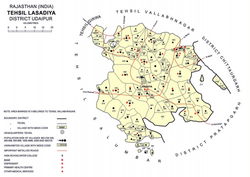
The area of Lasadiya tehsil is 539 square kilometres. [1] The tehsil is bordered by Girwa tehsil to the northwest, Vallabhnagar tehsil to the north, Chittaurgarh district to the north east, Pratapgarh district to the southeast, and Salumber tehsils to the southwest. [1] The annual average rainfall in Lasadiya tehsil is 692 mm, with an average of 32 rainy days per year. [2] [4]

Demographics

The population of Lasadiya tehsil is 91,229, which makes it the least populous tehsil in Udaipur district. [1] The entire population of Lasadiya is classified as rural in the 2011 census. [1] The sex ratio in the tehsil is 968. [1] 88% of the population belongs to one of the statutorily defined scheduled tribes. [1] The tehsil's literacy rate of 35% is the second lowest in Udaipur district. [1] 96% of the population of the tehsil is rural and the literacy rate of the tehsil is 54%. [1] Mewari is the predominant language used in the tehsil, being the first language for 98% of the population of the tehsil. [5]

Because of its predominant tribal population, Lasadiya tehsil is classified as a Scheduled Area which affords safeguards for interests of the tribal population. [6]

Economy

Agriculture is the most significant sources of income in Lasadiya tehsil with 90% of workers identifying as cultivators or agricultural labourers in the 2011 census. [3]

Related Research Articles

<span class="mw-page-title-main">Udaipur district</span> District of Rajasthan in India

Udaipur district is one of the 52 districts of Rajasthan state in western India. The historic city of Udaipur is the administrative headquarters of the district. The district is part of the Mewar region of Rajasthan.

Gogunda is a town and tehsil headquarters of Gogunda Tehsil in Udaipur district, located about 35 km (22 mi) in north-west from Udaipur city in the Indian state of Rajasthan. It is situated on a high mountain in Aravalli hills and is reached by crossing a difficult mountain pass.

<span class="mw-page-title-main">Sirohi district</span> District of Rajasthan in India

Sirohi District is a district of Rajasthan state in western India. The city of Sirohi is the district headquarters.

Salumbar is a city in Salumbar district, in the Indian state of Rajasthan. Salumbar is a part of "Mewar" dynasty. Salumbar is also known as "Hadirani nagri" which has history of queen Hadirani who sacrificed her life to motivate her husband to go to a battle.

<span class="mw-page-title-main">Pratapgarh district, Rajasthan</span> District of Rajasthan in India

Pratapgarh district is the 33rd district of Rajasthan, created on 26 January 2008. It is a part of Udaipur Division and has been carved out from the erstwhile tehsils of Chittorgarh, Udaipur and Banswara districts. Pratapgarh town is the administrative headquarters of the district.

Boraj Tawaran is a village in the Udaipur district of Rajasthan, India. It comes under the Malpur gram panchayat, in Salumber block. The village is located 8 km east of Salumber. It is also known as Boraj Tanwaran or Boraj Tavraan. Salumbar is nearest town to Boraj Tawaran village. Around 1700 CE, a Thakur of the Tanwar clan moved to Salumber during the rule of Rawat Kesari Singh Chundawat. In 1876, his descendant Thakur Tej Singh Tanwar was granted the jagir of the present-day village site to Rawat Jodh Singh Chundawat.

Girwa is a tehsil of Udaipur district, Rajasthan, India. The administrative headquarter of the tehsil is located in the City of Udaipur.

<span class="mw-page-title-main">Kotra tehsil</span> Tehsil in Udaipur, Rajasthan, India

Kotra is a tehsil of Udaipur district in Rajasthan, India, consisting of 262 revenue villages and 31 panchayats. The tehsil is bordered to the north by Pali and Sirohi districts, to the east by Gogunda and Jhadol tehsils, and to the south by Gujarat state. The tehsil headquarter is located in the village of Kotra, southwest of the Udaipur at a distance of 57 km and 120 km by road.

Semari is a tehsil of Salumbar district in Rajasthan, India. The administrative headquarter of the tehsil is located in the town of Semari.

<span class="mw-page-title-main">Jhadol tehsil</span> Tehsil in Udaipur, Rajasthan, India

Jhadol tehsil is an administrative sub-division of Udaipur district in Rajasthan, India. Jhadol tehsil was formerly called Phalasia tehsil. The tehsil consists of 283 revenue villages and 45 panchayats. The tehsil headquarter is located in the village of Jhadol, southwest of the district headquarters, Udaipur.

<span class="mw-page-title-main">Gogunda tehsil</span> Tehsil in Udaipur, Rajasthan, India

Gogunda is a tehsil of Udaipur district in Rajasthan, India. The tehsil consists of 232 revenue villages, 45 panchayats, and 1 census town. The tehsil headquarter is located in the town of Gogunda.

<span class="mw-page-title-main">Kherwara tehsil</span> Tehsil in Udaipur, Rajasthan, India

Kherwara is a tehsil of Udaipur district in Rajasthan, India. The tehsil consists of 195 revenue villages and 1 census town. The tehsil headquarter is located in the town of Kherwara Chhaoni. The tehsil is part of the Kherwara panchayat samiti (block).

<span class="mw-page-title-main">Mavli tehsil</span> Tehsil in Udaipur, Rajasthan

Mavli is a tehsil of Udaipur district in Rajasthan, India.The tehsil consists of 179 revenue villages which are organized in 42 gram panchayats and one town (Mavli). The tehsil headquarter is located in the town of Mavli. The boundaries of Mavli tehsil are conterminous with those of Mavli panchayat samiti.

Badgaon is a tehsil in Udaipur district of Rajasthan, India.

Bhindar is a tehsil of Udaipur district in Rajasthan, India. The tehsil headquarter is located in the town of Bhinder.

Kanor is a tehsil of Udaipur district in Rajasthan, India. As of April 2019, it is the 15th tehsil of Udaipur district and the youngest one, having been formed in 2018.

Vallabhnagar is a tehsil of Udaipur district in Rajasthan, India.

<span class="mw-page-title-main">Salumbar tehsil</span> Tehsil in Salumbar, Rajasthan, India

Salumbar is a tehsil of Salumbar district in Rajasthan, India.The tehsil consists of 268 revenue villages which are organized in 46 gram panchayats and one town. The tehsil headquarter is located in the town of Salumbar.

<span class="mw-page-title-main">Rishabhdeo tehsil</span> Tehsil in Udaipur, Rajasthan, India

Rishabhdeo is a tehsil of Udaipur district in Rajasthan, India.The tehsil consists of 125 revenue villages and one town. The tehsil headquarter is located in the town of Rishabhdeo.

Sarada is a tehsil of Salumbar district in Rajasthan, India. It consists of 152 villages and 3 towns. The tehsil headquarter is located in the village of Sarada.

References

  1. 1 2 3 4 5 6 7 8 9 10 11 12 13 14 District Census Handbook Udaipur, Village and Town Directory (PDF). Directorate of Census Operations. 2011.
  2. 1 2 Singh, O.P.; et al. (2013). Rainfall Profile of Udaipur (PDF). Meteorological Monograph: Hydrology No.15/2013. New Delhi: India Meteorological Department. p. 108.
  3. 1 2 3 District Census Handbook Udaipur, Village and Town Wise Primary Census Abstract (PDF). Directorate of Census Operations. 2011.
  4. Since Lasadiya tehsil only came in existence in 2008, the mean rainfall shown here reflects that of Salumber tehsil, parts of which were carved out to create the former.
  5. "C-16 Population By Mother Tongue". Census of India. Retrieved 5 September 2018.
  6. "Gazette of India". Government of India. 19 May 2019. Retrieved 13 April 2019.