
Sirsa district is the largest district of Haryana state by Area. Sirsa is the district headquarters. It is located on National Highway 9 and 250 kilometres (160 mi) from the capital Delhi. On 1 September 1975, Sirsa became a district by taking Sirsa and Dabwali tahsils from Hisar District. There are a total of 342 villages in Sirsa district.

Pachpadra is a small town, just 11 km from Balotra city in Balotra district in Indian state of Rajasthan. It is a tehsil headquarter. The nearest railway station of Pachpadra is Balotra railway station.

Barmer District is a district in Rajasthan state of India. It is located in the western part of Rajasthan state forming a part of the Thar Desert. Barmer is the third largest district by area in Rajasthan and fifth largest district in India, occupying an area of 28,387 km2. Being in the western part of the state, it includes a part of the Thar Desert. Jaisalmer is to the north of this district while Jalore is in its south. Pali and Jodhpur form its eastern border and it shares a border with Pakistan in the west. Partially being a desert, this district has a large variation in temperature. The temperature in summer can rise up to 51 °C and falls near to 0 °C in winter. Luni is the longest river in Barmer district. After travelling a length of almost 500 km, it passes through Jalore and merges in the marshy land of Runn of Kutch. District headquarters is in the town of Barmer. The other major towns in the district are: Balotra, Guda Malani, Baytoo, Siwana, and Chohatan. Recently, a large onshore oil field has been discovered and made functional in Barmer district. Barmer is also famous for pomegranate.

Balotra is a city situated in the Balotra district within the state of Rajasthan, India. Previously, it was located in the Barmer district of the Indian state of Rajasthan. It is known for its historical and cultural significance, as well as its role as a commercial and trading center in the region.
Siwana is a Municipality & Tehsil in Balotra district in Indian state of Rajasthan, located 151 km from Barmer. The place is known for its fort which is locally known as Gadh Siwana, Gadh means Fort. Siwana contains 130 villages and has a total population of 213,648, 111,155 male and 102,493 female.
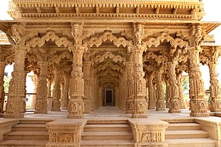
Jasol is a village in Pachpadra tehsil of Balotra District of the Indian state of Rajasthan.The historical village of Jasol, the capital of the former Malani area was ruled by the independent Mahecha clan of the Rathore Rajputs. It includes cenotaphs, and the temple of Rani Bhatiyani. The horses of the indigenous Malani breed are raised there.
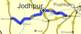
National Highway 112 is a National Highway in India entirely within the state of Rajasthan. NH 112 links Bar on NH 14 with Barmer on NH 15 and is 343 km (213 mi) long.
Chaudhary Harish Singh Godara, popularly known as "Harishji" in his Barmer Lok Sabha constituency, is a farmer leader and politician serving as the incharge of Indian National Congress organisation in Punjab and Chandigarh and Member of the Rajasthan Legislative Assembly from Baytu constituency of Barmer district in Rajasthan as an Indian National Congress party candidate which he won in the 2018 legislative assembly elections. He has also served as the Cabinet Minister of Revenue, Colonization and Water Cooperation of Rajasthan for about 3 years. He had won Lok Sabha elections in 2009 from the Barmer-Jaisalmer constituency in Rajasthan. But in 2014 elections, he lost. He was National Secretary of the All India Congress Committee till 2014–2019.
Tilwara, historically known as Khedgarh is a village in Pachpadra tehsil of Balotra district of Rajasthan state in India. Tilwara is situated on the Luni River and is a railway station on Jodhpur-Balotra route. The village is famous for Mallinath Fair, which is the most ancient animal fair of Rajasthan, held between eleventh of Krishna paksh to eleventh of Shukla paksh of Chaitra month of Hindu calendar every year. Also called Tilwara cattle fair, it lasts for two weeks. Tilwara is also an archeological site from where evidence for the Mesolithic culture have been excavated. Tilwara has a total population of 1,487 peoples according to Census 2011.
Moothali is a village in the suburb of Siwana, Balotra District, India. Rajput, Rajpurohit, Nai, Suthar, Jain, Meghwal and many other castes live in this village. According to Census 2011 information the location code or village code of Moothali village is 087522. Moothali village is located in Siwana Tehsil of Barmer district in Rajasthan, India. It is situated 20 km away from sub-district headquarter Siwana and 120 km away from district headquarter Barmer. As per 2009 stats, Moothali village is also a gram panchayat.
Mokalsar is a village in Siwana tehsil of Balotra District in Indian state of Rajasthan, located on RJ SH 38.
Khed/Kher is a village in Balotra District, of Rajasthan, India. It is 9 km from Balotra and situated on Baytu-Balotra Road. Kher has a total population of 1,163 peoples according to Census 2011.
National Highway 25 is a National Highway in India that connects Barmer and Beawar in the state of Rajasthan. It has recently been widened to four lanes by the National Highways Authority of India.
Baytoo is one of the 200 Legislative Assembly constituencies of Rajasthan state in India.
Dheedhas is a village of Balotra District in Rajasthan, northern India. Samuja and Dheedas are two villages in Dheedhas Gram Panchayat.The village is located in the Samdari tehsil. There are rivers Sukri and Luni on both sides of the village, Luni flows in the west of the village and Sukri flows in the east.Bajra and wheat bread and vegetables are mainly used in the food of the villagers. Farmer families reside more in the village. Crops are grown by the farmer in the rainy season, there are rivers on both sides of the village,Wells are the main means of irrigation in the village, all three crops are grown by the farmers. Dheedhas has a total population of 2,097 peoples according to Census 2011.
Madan Prajapat is an Indian politician from Rajasthan who has served in the Rajasthan Legislative Assembly since 2018. He previously served in the Rajasthan Legislative Assembly from 2008 to 2013. Prajapat represents Pachpadra as a member of the Indian National Congress.
Gida is a tehsil in Balotra District of Rajasthan State, India. It belongs to Jodhpur Division. Gira has a total population of 803 peoples according to Census 2011.
Pareu is a village in Baytu Tehsil, Balotra district, Rajasthan, India. Pareu has a total population of 1,640 according to the 2011 census.
Mewa Nagar is a village in Pachpadra tehsil of Balotra District, Rajasthan, India.
Majivala village in Pachpadra tehsil of Balotra district in Rajasthan, India. As of the 2011 India census, the total population of the village is 5882.

