Mavli tehsil | |
|---|---|
Tehsil | |
 Mavli tehsil | |
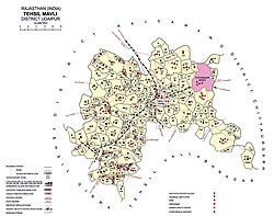
 Mavli tehsil Location of Mavli tehsil  Mavli tehsil Mavli tehsil (India) | |
| Coordinates: 24°47′30″N73°58′57″E / 24.791727°N 73.982498°E | |
| Tehsil seat | Mavli |
| Area | |
• Total | 837 km2 (323 sq mi) |
| [1] | |
| Population (2011) | |
• Total | 230,532 [2] |
| • Density | 275/km2 (713/sq mi) |
| Time zone | Indian Standard Time |
Mavli is a tehsil of Udaipur district in Rajasthan, India.The tehsil consists of 179 revenue villages which are organized in 42 gram panchayats and one town (Mavli). [1] The tehsil headquarter is located in the town of Mavli. [1] The boundaries of Mavli tehsil are conterminous with those of Mavli panchayat samiti. [1]