Chittorgarh district | |
|---|---|
     Clockwise from top-left: Kirti Stambha with nearby temple at Chittorgarh Fort, Rani Padmini Palace, Dewaria Balaji Temple in Nagari, View of Chittorgarh city, Baroli Temples | |
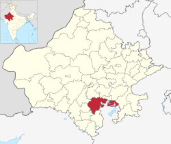 Chittorgarh district | |
| Country | |
| State | |
| Division | Udaipur |
| Headquarters | Chittaurgarh |
| Area | |
• Total | 7,822 km2 (3,020 sq mi) |
| Population (2011) [1] | |
• Total | 1,544,338 |
| • Density | 200/km2 (510/sq mi) |
| Time zone | UTC+05:30 (IST) |
Chittorgarh district is one of the 50 districts of Rajasthan state in western India. [2] The historic city of Chittaurgarh is the administrative headquarters of the district. [1] The district was established on 1 August 1948 by integrating portions of various princely states: Mewar, Pratabgarh, Tonk, and Jhalawar. [3] Chittaurgarh is famous for the Chittor fort, home to various famous Rajput dynasties.
