Demographics
While in the 2001 Indian census, Sagwara had a population of 30,993, [3] by the 2011 census that number had dropped to 29,439. [1] Males, while still fewer than females, increased their percentage from 49.3% to 49.9% of the population from 2001 to 2011. Sagwara significantly increased their average literacy rate from 2001 to 2011 going from 59% to 79%. Male literacy rose from 68% to 88%, and female literacy rose from 50% to 71%. From 2001 to 2011 the population in Sagwara aged, going from 16% below the age of six, to 13%. [1] [3]
Sagwara is the third largest populated place after Banswara and Dungarpur in the historical areas of Rajasthan. The majority of the population is of the Hindu religion and it also has a significant population of Jainism and Dawoodi Bohra (a Shia Islamic Muslim community).

Khetri Nagar is a town in the Neem Ka Thana district of Rajasthan in India. It is a part of the Shekhawati region. Khetri consists of two towns, "Khetri Town," founded by Raja Khet Singhji Nirwan, and "Khetri Nagar," which is about 10 km away from Khetri. Khetri Nagar, well known for its Copper Project, was built by and is under the control of Hindustan Copper Limited, a public sector undertaking under the Government of India. Khetri Nagar is also known as "Copper." There are many attached villages near Khetri Nagar, such as Manota Khurd; the people of this village were employed in mines.

Dungarpur District is a district of the state of Rajasthan in western India. The town of Dungarpur is the district headquarters.
Galiyakot is a town in Dungarpur District of Rajasthan, India. It is situated about 56 km from Dungarpur city and 168km from the Rajasthan city of Udaipur. It was controlled by the Parmar dynasty around Vikram Samvat 1000. In Vikram Samvat 1342, Rao Dedu (Devpal) Raja of the Sisodiya dynasty subdued Galiyakot. The predecessors of Dungarpur controlled Galiyakot for many years and settled in Dungarpur. It part of a Dawoodi Bohra pilgrimage site. It contains many Hindu temples, and is famous for the Shitla Mata Mandir and the tomb of Babjee Moula Syedi Fakhruddin.
Falna is a town and a tehsil in Pali District in Indian state of Rajasthan.

Asind is a city and a municipality in Bhilwara district, Rajasthan, India. It is a Tehsil (sub-division) for many villages The city have a magistrate office, lower justice court and many administrative hub for many major villages.
Dhariawad is a census town in Pratapgarh district in the state of Rajasthan, India. It is the administrative headquarters for Dhariawad Tehsil.
Garoth is a town in Madhya Pradesh state in central India. It is one of the tehsil of Mandsaur District.It shares boundary with Jhalawar district of Rajasthan.The local Language or dialect spoken here is a mixture of Mewari, Harauti and Malwi Languages.Latitude and longitude coordinates are: 24.328077, 75.649902.
Jirapur is a town and a nagar panchayat in Rajgarh district in the Indian state of Madhya Pradesh. In 2022 Janpad Panchayat election held across Madhya Pradesh, Congress won the election and secure position as a Janpad Adhyaksh under the leadership of Khilchipur vidhayak Shri Priyavrat Singh Ji. He put all the efforts to win this election and doing great work for Khilchipur constituency. He won 2018 assembly election of Madhya Pradesh with huge margin of 30,000+ votes by defeating Kunwar Hajarilal Dangi of Bharatiya Janata Party (BJP) candidate.
Mundwa also known as Marwar Mundwa, is a city and a municipality in Nagaur district in the Indian state of Rajasthan. Mundwa is a tehsil in Nagaur district of Rajasthan State, India. It is located 20 km towards South from district headquarters Nagaur. 231 km from state capital Jaipur towards East. Marwari is the Local Language here. Also People Speaks Hindi, English, Urdu and Rajasthani. Mundwa was also a constituency of Rajasthan Assembly before it was changed to Khinvsar because of political reasons. Now Mundwa is made a Tehsil. It is also allotted a Dhan Mandi. It is a pilgrimage centre for the shrine of the Sufi Haz Jana Sahid and is also famous for the lot of temples.
Nalkheda is a town (Tehsil) and a nagar Parishad in Agar Malwa district in the Indian state of Madhya Pradesh. Nalkheda is situated on the bank of river Lakhunder.
Rajaldesar is a City and a Tehsil in Churu District in the Indian State of Rajasthan. Rajaldesar is well connected through Indian Railways and National Highway 11 (India) also. Rajaldesar is known for its traditional dance Gindar which plays by male performers with a stick.
Sojat Road is a census town in Sojat tehsil of Pali district in the Indian state of Rajasthan. Sojat Road train station is located on Ajmer-Marwar Junction route and the most convenient method of traveling is by train.
Todaraisingh is a city and a municipality and tehsil headquarters in Kekri district in the Indian state of Rajasthan. Banas River flows adjacent to it. It is of immense importance to the Rajasthan's Art and Heritage.
Uniara is a town and a municipality in Tonk district in the Indian state of Rajasthan. It is a tehsil of the Tonk district.
Ramgarh or Ramgarh Shekhawati is a town and a municipality in Ramgarh tehsil of Sikar district in the Indian state of Rajasthan.
Obri is a Modern Town in Dungarpur Rajasthan in Rajasthan in western India. Administratively it is under Obri Tehsil of Dungarpur district, Rajasthan. Obri is the only village in the gram panchayat.
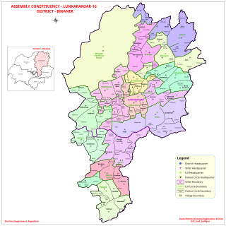
Lunkaransar is a town, near city of Bikaner in the Bikaner district of Indian state of Rajasthan. Lunkaransar lake in Rajasthan is a playa lake formed due to deflation. Lunkaransar is most popular for Peanuts in Rajasthan.
Simalwara is a census town in Dungarpur district in the Indian state of Rajasthan. It is the administrative headquarters for Simalwara Tehsil.
Bichhiwara is a panchayat village in Rajasthan in western India. Administratively, Bichhiwara is under Bichiwara Tehsil of Dungarpur District in Rajasthan. Bichhiwara is the administrative headquarters for its tehsil. The village of Bichhiwara is 11 km by road northeast of the border with Aravalli District, Gujarat, along National Highway 8 and 22 km by road west of the town of Dungarpur, the district capital. The nearest railway station is Bechhiwara railway station (BHWA), 1.3 km by road west of the village.
Dhambola is a panchayat village in Simalwara Tehsil of Dungarpur District, Rajasthan, India.
This page is based on this
Wikipedia article Text is available under the
CC BY-SA 4.0 license; additional terms may apply.
Images, videos and audio are available under their respective licenses.

