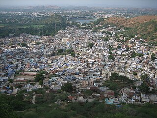
Banswara is a city in the Banswara district in southern Rajasthan, India. The name, Banswara, came from king ‘Bansiya Bhil’.
Dungarpur is a city in the southernmost part of Rajasthan, India.

Amreli is a city and a municipality in Amreli district in Indian state of Gujarat.

Dungarpur District is a district of the state of Rajasthan in western India. The town of Dungarpur is the district headquarters.
Galiyakot is a town in Dungarpur District of Rajasthan, India. It is situated about 56 km from Dungarpur city and 168 km from the Rajasthan city of Udaipur. It was controlled by the Parmar dynasty around Vikram Samvat 1000. In Vikram Samvat 1342, Rao Dedu (Devpal), Raja of the Sisodiya dynasty, subdued Galiyakot. The predecessors of Dungarpur controlled Galiyakot for many years before settling in Dungarpur. It is part of a Dawoodi Bohra pilgrimage site and contains many Hindu temples, including the Shitla Mata Mandir and the tomb of Babjee Moula Syedi Fakhruddin.
Amet is a town and a municipality located in Rajsamand district in the Indian state of Rajasthan.

Asind is a city and a municipality in Bhilwara district, Rajasthan, India. It is a Tehsil (sub-division) for many villages The city have a magistrate office, lower justice court and many administrative hub for many major villages.
Bagasara is a municipality in Bagasara Taluka of Amreli district, Gujarat, India. The town is situated on the northern bank of the Satalli river. nearest airport div airport.
Chanasma is a small town and a municipality in Chanasma Taluka of Patan district in the state of Gujarat, India. Chanasma is a seat of Gujarat Assembly. The MP seat of Chanasma falls in the Patan Lok Sabha. Chanasma village is connected by Kandla-Mehsana highway. And since the broad gauge of the railway is being renovated, it is going to connect with Rajasthan via Patan from Ahmedabad. Patel, Brahmin, Vania, Darji, Panchal, Parmar, Rabari, Thakor, Nayi, all communities live in Chansma village. The old village of Chanasma was between Ugmano Darwaza and Athamano Darwaza. But now due to the increase in population and development of the village, the village is spreading to the outside. Chansma Village Shree Laljidas Laxmidas Patel Trust runs Rotla Ghar for feeding the poor where clean and nutritious meals are provided to the poor for free.

Dhoraji is a town situated on the banks of the River Safura, a tributary of the River Bhadar. It is a municipality in the Rajkot district in the state of Gujarat, India.
Jasdan is a city and a municipality in Rajkot district in the Indian state of Gujarat. Jasdan is the biggest sub district in the Rajkot district. Jasdan city has its own Municipality that is known as "Jasdan Municipality" JMP.

Khedbrahma is a town and a taluka headquarter in Khedbrahma Taluka of Sabarkantha district, Gujarat, India. It is situated on the banks of Harnav river. The town is connected with mythological history and has been pilgrim site for centuries. The 11th century Brahma, Ambika and Pankhnath Mahadev temples are the oldest monuments of the town. The town has an old stepwell, the Brahma Vav. It was under Parmaras, Chaulukyas and Pariharas before it came under Idar State in 13th century.
Kherwara Chhaoni is a census town in the Udaipur district in the Indian state of Rajasthan. It is part of the Vagad region, which includes the districts of Dungarpur, Banswara and parts of Udaipur district. It is in close proximity to two major highways, National Highway 8 and Rajasthan State Highway 76 and National Highway 927A passes through it. Its name derives from the large number of Kher (Khair) trees in the region in the past.
Kodinar is a town and municipality in Gir Somnath district, in the Indian state of Gujarat, 37 kilometres (23 mi) west of Una. Kodinar is close to the Gir Forest National Park. The main transport connections for Kodinar are Diu Airport, Veraval Junction railway station, and Veraval Port.
Meghraj is a town in the Indian state of Gujarat.
Nawa is a city, tehsil headquarters, panchayat samiti, and a municipality in Didwana Kuchaman District in the Indian state of Rajasthan. It is the Biggest Salt Market of Rajasthan.

Sadri is a municipality in the Pali district of Rajasthan, India. It is considered the gateway to Marwar from Mewar. Sadri is one of the main places of worship for the Jain community. Ranakpur Temple and Shri Parshuram Mahadev Mandir are located in Sadri, which became a municipality in 1961. Bhadras is located 3 km from Sadri along the Suhai river.
Sagwara is a city and municipality, near Dungarpur city in Dungarpur district in the Indian state of Rajasthan. It is one of two towns in Sagwara Tehsil, and the administrative center for the Sagwara Tehsil's additional district court and sub jailkshla.
Baneshwar fair is an annual tribal fair held in Dungarpur district in Rajasthan state of India. The fair is held in the month of January or February at Baneshwar, near the confluence of the Som and Mahi rivers. This fair is a major fair in tribal culture and has been described as "the Kumbh mela for the tribals".
Dhambola is a panchayat village in Simalwara Tehsil of Dungarpur District, Rajasthan, India.

