Climate of Rajasthan

Last updated

Rajasthan canal Shivender.jpg
Indira Gandhi Canal was necessitated by water scarcity in Thar Desert, covering western part of Rajasthan.
Mt. Abu.jpg
Mount Abu is one of the coolest places in Rajasthan.
An aerial view of Udaipur and Aravali hills Rajasthan India 2012.jpg
Aerial view Udaipur and Aravali hills.

The climate of Rajasthan in northwestern India is generally arid or semi-arid and features fairly hot temperatures over the year with extreme temperatures in both summer and winter. The hottest months are May and June. The monsoon season is from July to September; however, rainfall remains moderate. [1]

Contents

History

Under the Köppen climate classification the greater part of Rajasthan falls under Hot Desert (BWh) and remaining portions of the state falls under Hot Semi Arid (BSh); the climate of the state ranges from arid to semi-arid. Rajasthan receives low and variable rainfalls and thereby is prone to droughts. As Rajasthan is the dry and hot state, Unbelievable hailstorm covered Nagaur, Rajasthan in a thin snow-like icy blanket in December 2019. Later on, it is clarified that this is not a snowfall but a hailstorm, endorse by western disturbances. The climate has changed in winters like never before. [2]

Seasons

Summer

Due to the Desert Geography, frequently climb above 40 to 45 degrees Celsius in most places. Due to its location, summers are the longest season in Rajasthan. In this time tourist activities are very low.

Winter

The cold weather commences early in October and ends around the end of February and sometimes the temperatures reach nearly 2-degree Celsius [*record in 1964 in JAIPUR the temperature reached 0-degree Celsius on 13 December.]

Monsoon

The state has two distinct periods of rainfall: rainfall due to the South-West Monsoon after summer and rainfall due to Western Disturbances.

Temperature

Average temperatures in various cities of Rajasthan(°C)
Winter
(Jan - Feb)
Summer
(Mar – May)
Monsoon
(Jun – Sep)
Post-monsoon
(Oct – Dec)
Year-round
JanFebMarAprMayJunJulAugSepOctNovDecAvg
Jaipur(Highest) [3] 22.425.031.037.140.339.334.132.433.833.629.224.431.9
Jaipur(Lowest) [3] 08.410.816.021.825.927.425.824.723.219.413.89.218.8

Precipitation

Average precipitation in various cities of Rajasthan(mm)
Winter
(Jan – Feb)
aSummer
(Mar – May)
Monsoon 1
(Jun – Sep)
Monsoon 2
(Oct – Dec)
Year-round
CityJanFebMarAprMayJunJulAugSepOctNovDecTotal
Jaipur [3] 7.010.63.14.917.963.4223.3205.966.325.03.94.2637.4

Disasters

Drought and famine

Rajasthan receives low and variable rainfalls and thereby is prone to droughts. Availability of water is less due to the absence of rivers and lakes.

Floods

Occasional floods in cities due to improper drainage occurs. Sometimes floods also occur in western Rajasthan due to impervious base rocks.

Pollution

In some industrial and urban centers pollution has been reported occasionally.

Climate data

Climate data for Jaipur (Köppen BSh)
MonthJanFebMarAprMayJunJulAugSepOctNovDecYear
Record high °C (°F)31.7
(89.1)
36.7
(98.1)
42.8
(109.0)
44.9
(112.8)
49.0
(120.2)
47.2
(117.0)
46.7
(116.1)
41.7
(107.1)
41.7
(107.1)
40.0
(104.0)
36.4
(97.5)
31.5
(88.7)
49.0
(120.2)
Mean maximum °C (°F)27.2
(81.0)
31.4
(88.5)
37.1
(98.8)
41.9
(107.4)
44.3
(111.7)
43.7
(110.7)
39.4
(102.9)
36.1
(97.0)
37.5
(99.5)
36.9
(98.4)
33.1
(91.6)
28.3
(82.9)
44.8
(112.6)
Mean daily maximum °C (°F)22.6
(72.7)
25.7
(78.3)
31.6
(88.9)
37.4
(99.3)
40.7
(105.3)
39.6
(103.3)
34.6
(94.3)
32.7
(90.9)
34.2
(93.6)
33.8
(92.8)
29.3
(84.7)
24.5
(76.1)
32.2
(90.0)
Mean daily minimum °C (°F)8.6
(47.5)
11.4
(52.5)
16.8
(62.2)
22.2
(72.0)
26.5
(79.7)
27.7
(81.9)
26.1
(79.0)
24.8
(76.6)
23.6
(74.5)
19.6
(67.3)
14.0
(57.2)
9.5
(49.1)
19.2
(66.6)
Mean minimum °C (°F)3.8
(38.8)
6.1
(43.0)
11.3
(52.3)
16.7
(62.1)
20.9
(69.6)
22.2
(72.0)
23.1
(73.6)
22.3
(72.1)
20.8
(69.4)
15.2
(59.4)
9.1
(48.4)
4.8
(40.6)
3.5
(38.3)
Record low °C (°F)−2.2
(28.0)
−2.2
(28.0)
3.3
(37.9)
9.4
(48.9)
15.6
(60.1)
19.1
(66.4)
20.6
(69.1)
18.9
(66.0)
15.0
(59.0)
11.1
(52.0)
3.3
(37.9)
0.0
(32.0)
−2.2
(28.0)
Average rainfall mm (inches)5.9
(0.23)
10.2
(0.40)
4.4
(0.17)
7.1
(0.28)
12.2
(0.48)
61.9
(2.44)
190.5
(7.50)
203.4
(8.01)
79.6
(3.13)
19.4
(0.76)
1.9
(0.07)
3.8
(0.15)
600.3
(23.63)
Average rainy days0.60.90.70.91.34.29.49.84.81.20.20.334.3
Average relative humidity (%) (at 17:30 IST)37292117193360675031343936
Average dew point °C (°F)6
(43)
7
(45)
7
(45)
8
(46)
12
(54)
19
(66)
24
(75)
24
(75)
21
(70)
13
(55)
9
(48)
6
(43)
13
(55)
Average ultraviolet index 5791112121212108659
Source 1: India Meteorological Department [4] [5] [6] Time and Date (dewpoints, 2005-2015) [7]
Source 2: Weather Atlas [8]
Climate data for Jodhpur (Köppen BWh/BSh)
MonthJanFebMarAprMayJunJulAugSepOctNovDecYear
Record high °C (°F)31.2
(88.2)
36.0
(96.8)
41.6
(106.9)
45.0
(113.0)
48.9
(120.0)
47.8
(118.0)
42.6
(108.7)
40.3
(104.5)
42.5
(108.5)
40.6
(105.1)
37.5
(99.5)
32.3
(90.1)
48.9
(120.0)
Mean daily maximum °C (°F)24.5
(76.1)
27.4
(81.3)
33.4
(92.1)
38.4
(101.1)
41.2
(106.2)
40.0
(104.0)
35.2
(95.4)
33.5
(92.3)
34.9
(94.8)
35.8
(96.4)
31.2
(88.2)
26.9
(80.4)
33.5
(92.3)
Mean daily minimum °C (°F)9.6
(49.3)
11.7
(53.1)
17.3
(63.1)
22.6
(72.7)
26.5
(79.7)
27.8
(82.0)
26.4
(79.5)
25.4
(77.7)
23.9
(75.0)
20.1
(68.2)
14.7
(58.5)
11.2
(52.2)
19.8
(67.6)
Record low °C (°F)1.8
(35.2)
0.7
(33.3)
4.4
(39.9)
15.6
(60.1)
15.4
(59.7)
20.0
(68.0)
21.0
(69.8)
21.2
(70.2)
18.4
(65.1)
12.5
(54.5)
5.8
(42.4)
1.7
(35.1)
0.7
(33.3)
Average rainfall mm (inches)4.0
(0.16)
4.0
(0.16)
1.3
(0.05)
4.8
(0.19)
17.4
(0.69)
40.0
(1.57)
120.5
(4.74)
111.8
(4.40)
49.9
(1.96)
6.9
(0.27)
1.9
(0.07)
0.5
(0.02)
362.9
(14.29)
Average rainy days0.30.60.30.61.22.16.55.92.60.60.20.021.0
Average relative humidity (%) (at 17:30 IST)27242219203352584529323332
Average dew point °C (°F)6
(43)
7
(45)
7
(45)
8
(46)
12
(54)
19
(66)
24
(75)
24
(75)
21
(70)
13
(55)
9
(48)
6
(43)
13
(55)
Mean monthly sunshine hours 303.8291.0288.3279.0285.2132.096.1120.9180.0232.5270.0294.52,773.3
Mean daily sunshine hours 9.810.39.39.39.24.43.13.96.07.59.09.57.6
Average ultraviolet index 5791112121212108659
Source 1: India Meteorological Department (sun 1971–2000) [9] [10] [11] [12] Time and Date (dewpoints, 2005-2015) [13]
Source 2: Weather Atlas [14]
Climate data for Bikaner (Köppen BWh)
MonthJanFebMarAprMayJunJulAugSepOctNovDecYear
Record high °C (°F)32.9
(91.2)
37.2
(99.0)
42.8
(109.0)
47.2
(117.0)
49.4
(120.9)
48.9
(120.0)
47.8
(118.0)
43.4
(110.1)
43.9
(111.0)
42.2
(108.0)
38.5
(101.3)
33.5
(92.3)
49.4
(120.9)
Mean daily maximum °C (°F)23.4
(74.1)
26.6
(79.9)
32.4
(90.3)
38.4
(101.1)
42.0
(107.6)
41.6
(106.9)
38.6
(101.5)
37.3
(99.1)
37.6
(99.7)
36.2
(97.2)
31.1
(88.0)
25.6
(78.1)
34.2
(93.6)
Mean daily minimum °C (°F)7.3
(45.1)
10.9
(51.6)
16.7
(62.1)
22.6
(72.7)
27.4
(81.3)
29.3
(84.7)
28.4
(83.1)
27.2
(81.0)
25.7
(78.3)
20.2
(68.4)
13.6
(56.5)
8.3
(46.9)
19.8
(67.6)
Record low °C (°F)−4.0
(24.8)
−2.5
(27.5)
−0.6
(30.9)
8.3
(46.9)
13.7
(56.7)
17.8
(64.0)
20.5
(68.9)
20.6
(69.1)
16.5
(61.7)
7.6
(45.7)
0.6
(33.1)
−2.8
(27.0)
−4.0
(24.8)
Average rainfall mm (inches)6.2
(0.24)
9.0
(0.35)
8.4
(0.33)
7.4
(0.29)
29.4
(1.16)
39.6
(1.56)
92.5
(3.64)
54.5
(2.15)
25.6
(1.01)
12.3
(0.48)
1.0
(0.04)
2.4
(0.09)
288.4
(11.35)
Average rainy days0.71.00.91.11.82.35.03.52.00.40.20.219.1
Average relative humidity (%) (at 17:30 IST)33272015172745473725303530
Average dew point °C (°F)3
(37)
5
(41)
7
(45)
9
(48)
13
(55)
19
(66)
23
(73)
23
(73)
20
(68)
12
(54)
8
(46)
5
(41)
12
(54)
Average ultraviolet index 5679998887647
Source 1: India Meteorological Department [15] [16] Time and Date (dewpoints, 2005-2015) [17]
Source 2: Weather Atlas [18]
Climate data for Jaisalmer (Köppen BWh)
MonthJanFebMarAprMayJunJulAugSepOctNovDecYear
Record high °C (°F)35.8
(96.4)
37.8
(100.0)
42.3
(108.1)
45.8
(114.4)
48.0
(118.4)
49.2
(120.6)
47.0
(116.6)
43.3
(109.9)
43.3
(109.9)
42.2
(108.0)
38.8
(101.8)
34.4
(93.9)
49.2
(120.6)
Mean daily maximum °C (°F)23.8
(74.8)
27.3
(81.1)
33.3
(91.9)
39.1
(102.4)
41.9
(107.4)
40.9
(105.6)
38.1
(100.6)
36.6
(97.9)
37.1
(98.8)
36.5
(97.7)
31.3
(88.3)
25.4
(77.7)
34.3
(93.7)
Mean daily minimum °C (°F)7.4
(45.3)
10.8
(51.4)
18.1
(64.6)
21.8
(71.2)
24.8
(76.6)
25.8
(78.4)
25.3
(77.5)
25.0
(77.0)
24.2
(75.6)
19.4
(66.9)
14.0
(57.2)
8.8
(47.8)
18.6
(65.5)
Record low °C (°F)−5.9
(21.4)
−4.4
(24.1)
3.4
(38.1)
10.6
(51.1)
15.1
(59.2)
17.2
(63.0)
20.1
(68.2)
19.1
(66.4)
12.9
(55.2)
8.3
(46.9)
2.0
(35.6)
−0.6
(30.9)
−5.9
(21.4)
Average rainfall mm (inches)1.3
(0.05)
5.2
(0.20)
3.3
(0.13)
7.2
(0.28)
17.2
(0.68)
31.0
(1.22)
79.2
(3.12)
92.2
(3.63)
39.3
(1.55)
3.0
(0.12)
0.7
(0.03)
2.1
(0.08)
271.6
(10.69)
Average rainy days0.20.60.40.50.61.25.36.22.40.30.10.217.0
Average relative humidity (%) (at 17:30 IST)31262219212945503926273131
Average dew point °C (°F)7
(45)
10
(50)
13
(55)
14
(57)
17
(63)
22
(72)
24
(75)
24
(75)
23
(73)
18
(64)
13
(55)
9
(48)
16
(61)
Average ultraviolet index 5688988887647
Source 1: India Meteorological Department [19] [20] Time and Date (dewpoints, 2005-2015) [21]
Source 2: Weather Atlas [22]

See also

Related Research Articles

<span class="mw-page-title-main">Thar Desert</span> Large arid region in India and Pakistan

The Thar Desert, also known as the Great Indian Desert, is an arid region in the north-western part of the Indian subcontinent that covers an area of 200,000 km2 (77,000 sq mi) in India and Pakistan. It is the world's 18th-largest desert, and the world's 9th-largest hot subtropical desert.

<span class="mw-page-title-main">Pokhran</span> Town in Rajasthan, India

Pokhran is a town and a municipality located 112 km east of Jaisalmer city in the Jaisalmer district of the Indian state of Rajasthan. It is situated in the Thar Desert region. Surrounded by rocks, sand and five salt ranges, the word "Pokaran" (पोकरण) means "place surrounded by five salt-ranges" in Rajasthani. The site for India's first and second underground nuclear weapon test is near Pokhran.

<span class="mw-page-title-main">Bikaner</span> City in Rajasthan, India

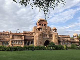
Bikaner is a city in the northwest of the state of Rajasthan, India. It is located 330 kilometres (205 mi) northwest of the state capital, Jaipur. Bikaner city is the administrative headquarters of Bikaner District and Bikaner division.

<span class="mw-page-title-main">Jodhpur</span> Metropolis in Rajasthan, India

Jodhpur is the second-largest city of the north-western Indian state of Rajasthan after its capital Jaipur. As of 2011, the city has a population of 1.03 million. It serves as the administrative headquarters of the Jodhpur district and Jodhpur division. It is historic capital of the Kingdom of Marwar, founded in 1459 by Rao Jodha, a Rajput chief of the Rathore clan. On 11 Aug, 1947 four days prior to the Indian independence, Maharaja Hanwant Singh, the last ruler of Jodhpur state signed the Instrument of Accession and merged his state in Union of India. On March 30, 1949, it became part of the newly formed state of Rajasthan, which was created after merging the states of the erstwhile Rajputana Agency.

<span class="mw-page-title-main">Jaisalmer</span> City in Rajasthan, India

Jaisalmer, nicknamed "The Golden city", is a city in the Indian state of Rajasthan, located 575 kilometres (357 mi) west of the state capital Jaipur. It is the administrative headquarters of Jaisalmer District. Before Indian independence, the town served as the capital of the Jaisalmer State, ruled by the Bhati Rajputs. Jaisalmer stands on a ridge of yellowish sandstone and is crowned by the ancient Jaisalmer Fort. This fort contains a royal palace and several ornate Jain temples. Many of the houses and temples of both the fort and of the town below are built of finely sculptured yellow sandstone. The town lies in the heart of the Thar Desert and has a population, including the residents of the fort, of about 78,000. Jaisalmer ranked 9th on Booking.com's Top 10 The Most Welcoming cities in the world. It is the only Indian city on the list.

Churu is a city in the desert region of Rajasthan state of India. It is known as the gateway to the Thar Desert of Rajasthan. It is the administrative headquarter of Churu District. It lies in the Thar Desert on the National Highway 52 connecting Sangrur to Ankola and is a junction station on the railway line to Bikaner. It is near the shifting sand dunes of the Thar Desert and has grand havelis with marvelous fresco paintings, namely Kanhaiya Lal Bagla Ki Haweli and Surana Haweli, with hundreds of small windows. It also has some fine Chhatris. Near the town is a religious seat of the Nath sect of Sadhus where there are life-size marble statues of their deities and a place for prayers. At the center of the town is a fort built about 500 years ago.

<span class="mw-page-title-main">Marwar</span> Region in Rajasthan, India

Marwar is a region of western Rajasthan state in North Western India. It lies partly in the Thar Desert. The word 'maru' is Sanskrit for desert. In Rajasthani languages, "wad" means a protected area. English translation of the word 'marwar' is the region protected by desert.

<span class="mw-page-title-main">Barmer district</span> District of Rajasthan in India

Barmer District is a district in Rajasthan state of India. It is located in the western part of Rajasthan state forming a part of the Thar Desert. Barmer is the third largest district by area in Rajasthan and fifth largest district in India, occupying an area of 28,387 km2. Being in the western part of the state, it includes a part of the Thar Desert. Jaisalmer is to the north of this district while Jalore is in its south. Pali and Jodhpur form its eastern border and it shares a border with Pakistan in the west. Partially being a desert, this district has a large variation in temperature. The temperature in summer can rise up to 51 °C and falls near to 0 °C in winter. Luni is the longest river in Barmer district. After travelling a length of almost 500 km, it passes through Jalore and merges in the marshy land of Runn of Kutch. District headquarters is in the town of Barmer. The other major towns in the district are: Balotra, Guda Malani, Baytoo, Siwana, and Chohatan. Recently, a large onshore oil field has been discovered and made functional in Barmer district. Barmer is also famous for pomegranate.

<span class="mw-page-title-main">Jaisalmer district</span> District in Rajasthan, India

Jaisalmer district is the largest district in the Indian state of Rajasthan, and the third largest district in India. Located in Marwar, the city of Jaisalmer is the administrative headquarters of the district. It is around 289 km (180 mi) from the city of Jodhpur, and around 559 km (347 mi) from Jaipur, the capital of Rajasthan. As of the 2011 population census, it is the least populous district out of all 33 districts in Rajasthan.

<span class="mw-page-title-main">Indira Gandhi Canal</span> Longest canal in India

The Indira Gandhi Canal is the longest canal in India. It starts at the Harike Barrage near Harike, a few kilometers downriver from the confluence of the Satluj and Beas rivers in Punjab state, and ends in irrigation facilities in the Thar Desert in the northwest of Rajasthan state. Previously known as the Rajasthan Canal, it was renamed the Indira Gandhi Canal on 2 November 1984 following the assassination of Prime Minister Indira Gandhi.

Phalodi is a city in Phalodi district in the Indian state of Rajasthan. It is the headquarters for Phalodi district. Phalodi is also called the "salt city" due to the salt industry in Rin. Phalodi is in the buffer zone of Thar Desert and often subject to extreme temperature conditions due to its arid climate. The highest temperature in the history of Phalodi is 51°C, which is the highest ever verified temperature in the country.

Delhi features a dry winter humid subtropical climate bordering a hot semi-arid climate, with high variation between summer and winter temperatures and precipitation. Delhi's version of a humid subtropical climate is markedly different from many other humid subtropical cities such as São Paulo, Houston, and Brisbane in that the city features dust storms and wildfire haze due to its semi-arid climate.

There is a huge variation in the climatic conditions of Himachal Pradesh due to variation in altitude. The climate varies from hot and sub-humid tropical in the southern low tracts, warm and temperate, cool and temperate and cold glacial and alpine in the northern and eastern high elevated mountain. Pollution is affecting the climate of almost all the states of India.

Located in eastern India, Bihar is the twelfth-largest Indian state, with an area of 94,163 km2 (36,357 mi2) and an average elevation of about 150 metres above mean sea level. The landlocked state shares a boundary with Nepal to the north, the state of West Bengal to the east, Jharkhand to the south, and Uttar Pradesh to the west. Bihar lies in a subtropical temperate zone and its climatic type is humid subtropical.

<span class="mw-page-title-main">Climate of Gujarat</span>

The climate of Gujarat involves diverse conditions. The plains of Gujarat are very hot and humid in summer and cold and dry in winter. Summer is milder in the hilly regions and the coast. The average daytime temperature during winter is around 29 °C (84 °F) and in nights is around 12 °C (54 °F) with 100 percent sunny days and clear nights. During summers, the daytime temperature is around 49 °C (120 °F) and at night no lower than 30 °C (86 °F). The monsoon season lasts from June to September. Most of Gujarat receives scant rainfall. Southern Gujarat and the hilly regions receive heavy rainfall during the monsoons with high humidity which makes the air feel hotter. There is relief when the monsoon season starts. The day temperatures are lowered to around 35 °C (95 °F) but humidity is very high and nights are around 27 °C (81 °F). Most of the rainfall occurs in this season, and the rain can cause severe Floods. The sun is often occluded during the monsoon season. Though mostly dry, it is desertic in the north-west, and wet in the southern districts due to a heavy monsoon season.

<span class="mw-page-title-main">Climate of Agra</span>

The climate of Agra features a semi-arid climate that borders on a humid subtropical climate. The city features mild winters, hot and dry summers and a monsoon season. The monsoon, though substantial in Agra, is not quite as heavy as the monsoon in other parts of India. The average monsoon rainfall from June to September is 628.6 millimeters. Agra has a reputation of being one of the hottest and the coldest towns in India. In summer the city witnesses a sudden surge in temperature and at times, mercury goes beyond the 46 °C mark in addition to a very high level of humidity. During summer, the daytime temperature hovers around 46-50 °C. Nights are relatively cooler and temperature lowers to 30 °C. Winter minimum temperatures sometimes go as low as 3 or 3.5 °C but usually hover in the range of 6 to 8 °C.

The climate of Uttar Pradesh (U.P.) is primarily defined as humid subtropical with dry winter (Cwa) type with parts of Western U.P. as hot semi-arid (BSh) type. Alternatively, some authors refer to it as tropical monsoon. Variations do exist in different parts of the large state. However, the uniformity of the vast Indo-Gangetic Plain forming the bulk of the state gives a predominantly single climatic pattern to the state with minor regional variations. U.P. has a climate of extremes. With temperatures fluctuating anywhere from 0 °C or 32 °F to 50 °C or 122 °F in several parts of the state and cyclical droughts and floods due to unpredictable rains, the summers are extremely hot, winters are cold and the rainy season can be either very wet or very dry.

Sri Gurusar Modia is a village in the Indian state of Rajasthan situated near borders of Rajasthan, Haryana and Punjab states and the international border of India and Pakistan. This village is located in the tehsil Suratgarh of district Sriganganagar. Suratgarh, once known as Sodhal was believed to be surrounded by the confluence of Saraswati and Drishyati rivers but now the land is a deserted one lying amidst the expanse of The great Indian Thar desert. Suratgarh is famous for its agriculture, air force and army base stations, largest thermal power plant of Rajasthan and largest radio station of Rajasthan called as "Cotton City Channel". Sri Gurusar Modia came into limelight when a controversial self-proclaimed saint and spiritual leader Gurmeet Ram Rahim Singh was believed to be incarnated there and crowned to the throne of Dera Sacha Sauda at Sirsa in 1991. With setting up of Shah Satnam Schools for both boys and girls, super speciality hospitals etc. this village became nationwide popular

<span class="mw-page-title-main">Climate of Tamil Nadu</span> Climate of Tamil Nadu (State in South India)

The Climate of Tamil Nadu, India is generally tropical and features fairly hot temperatures over the year except during the monsoon seasons. The city of Chennai lies on the thermal equator, which means Chennai and Tamil Nadu does not have that much temperature variation.

<span class="mw-page-title-main">Malasar (village)</span> Village in the Bikaner District of Rajasthan State in India

Malasar(हिंदी: मालासर) is a large village located in Bikaner District which is in the north-west of the state of Rajasthan, India. This village is the Panchayat headquarters of three nearby villages. There are a total of 450 houses in the village. This village is popular for its unique geographical location, beautiful sand dunes and sandy paths located in the heart of the Thar Desert.

References

  1. "Rajasthan: temperature, climate & weather".
  2. "Watch | is it Snowing in Rajasthan? Mind-Boggling Video Goes Viral on Twitter". 15 December 2019.
  3. 1 2 3 "Jaipur Climatological Table Period: 1971–2000". India Meteorological Department. Archived from the original on 2 April 2015. Retrieved 30 March 2017.
  4. "Station: Jaipur (Sanganer) Climatological Table 1981–2010" (PDF). Climatological Normals 1981–2010. India Meteorological Department. January 2015. pp. 343–344. Archived from the original (PDF) on 5 February 2020. Retrieved 19 March 2020.
  5. "Extremes of Temperature & Rainfall for Indian Stations (Up to 2012)" (PDF). India Meteorological Department. December 2016. p. M180. Archived from the original (PDF) on 5 February 2020. Retrieved 19 March 2020.
  6. "Jaipur (Sanganer)(42348)". India Meteorological Department. Retrieved 2 August 2022.
  7. "Climate & Weather Averages in Jaipur, Rajasthan, India". Time and Date. Retrieved 18 July 2022.
  8. "Climate and monthly weather forecast Jaipur, India". Weather Atlas. Retrieved 13 June 2022.
  9. "Station: Jodhpur RS/RW Climatological Table 1971–2000" (PDF). Climatological Normals 1971–2000. India Meteorological Department. October 2011. pp. 365–366. Archived from the original (PDF) on 15 February 2020. Retrieved 6 April 2020.
  10. "Extremes of Temperature & Rainfall for Indian Stations (Up to 2012)" (PDF). India Meteorological Department. December 2016. p. M183. Archived from the original (PDF) on 5 February 2020. Retrieved 6 April 2020.
  11. "Highest Maximum Temperature (°C) Ever Recorded" (PDF). India Meteorological Department. Retrieved 6 April 2020.
  12. "Table 3 Monthly mean duration of Sun Shine (hours) at different locations in India" (PDF). Daily Normals of Global & Diffuse Radiation (1971–2000). India Meteorological Department. December 2016. p. M-3. Archived from the original (PDF) on 5 February 2020. Retrieved 6 April 2020.
  13. "Climate & Weather Averages in Jodhpur, Rajasthan, India". Time and Date. Retrieved 22 July 2022.
  14. "Climate and monthly weather forecast Jodhpur, India". Weather Atlas. Retrieved 13 June 2022.
  15. "Station: Bikaner(P.B.O) Climatological Table 1981–2010" (PDF). Climatological Normals 1981–2010. India Meteorological Department. January 2015. pp. 151–152. Archived from the original (PDF) on 5 February 2020. Retrieved 20 January 2021.
  16. "Extremes of Temperature & Rainfall for Indian Stations (Up to 2012)" (PDF). India Meteorological Department. December 2016. p. M176. Archived from the original (PDF) on 5 February 2020. Retrieved 20 January 2021.
  17. "Climate & Weather Averages in Bikaner, Rajasthan, India". Time and Date. Retrieved 20 July 2022.
  18. "Climate and monthly weather forecast Bikaner, India". Weather Atlas. Retrieved 13 June 2022.
  19. "Station: Jaisalmer Climatological Table 1981–2010" (PDF). Climatological Normals 1981–2010. India Meteorological Department. January 2015. pp. 345–346. Archived from the original (PDF) on 5 February 2020. Retrieved 20 January 2021.
  20. "Extremes of Temperature & Rainfall for Indian Stations (Up to 2012)" (PDF). India Meteorological Department. December 2016. p. M181. Archived from the original (PDF) on 5 February 2020. Retrieved 20 January 2021.
  21. "Climate & Weather Averages in Jaisalmer, Rajasthan, India". Time and Date. Retrieved 20 July 2022.
  22. "Climate and monthly weather forecast Jaisalmer, India". Weather Atlas. Retrieved 13 June 2022.