Bhilwara district

Last updated

Bhilwara district
Bijoliya Parasnath 49.jpg
Shahpura Mahal.jpg
Amargarh Fort, Rajasthan, India.jpg
Jahazpur Fort, Rajasthan, India.jpg
Feel the breeze - panoramio.jpg
Clockwise from top-left: Bijolia Parshvanath temple, Shahpura Palace, Jahazpur Fort, Lake near Bhilwara, Amargarh Fort
Bhilwara in Rajasthan (India).svg
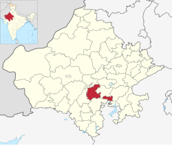
Location of Bhilwara district in Rajasthan
CountryFlag of India.svg  India
State Rajasthan
Division Ajmer
Headquarters Bhilwara
Government
  District CollectorAshish Modi
  Superintendent of PoliceAdarsh Sidhu
Area
  Total10,455 km2 (4,037 sq mi)
Population
 (2011) [1]
  Total2,408,523
  Density230/km2 (600/sq mi)
Time zone UTC+05:30 (IST)
Website bhilwara.rajasthan.gov.in

Bhilwara District is a district of the state of Rajasthan in western India. The city of Bhilwara is the district headquarters.

Contents

History

Stone Age tools dating from 5,000 to 200,000 years were found in Bundi and Bhilwara districts of the state. [2]

Geography

The district has an area of 10,455 km², and a population of 2,408,523 (2011 census), which increased 19.60% from 2001 to 2011. Famous for its textile & minerals Industries. It is bounded on the north by Ajmer District, on the east by Bundi District, on the south by Chittorgarh District and on the west by Rajsamand District. State Highway (Jaipur-Udaipur) passes through the district, as does a broad gauge railway line measuring 84 km and connecting Ajmer with Khandwa in Madhya Pradesh. The nearest airport is at Udaipur (171 km).

Administration

There are 7 sub-divisions in the district: Bhilwara, Shahpura, Gangapur, Gulabpura, Asind, Mandalgarh and Jahazpur. Under these sub-divisions there are 12 Tehsils as per Census of India 2011 report and these 12 Tehsils are Panachayat Samitis: Bhilwara, Banera, Mandal, Mandalgarh, Beejoliya, Kotri, Hurda, Shahpura, Jahazpur, Sahada, Asind and Raipur. There are four Sub Tehsils under the Tehsils mentioned in () also named Bagor (Mandal), Badnor (Asind), Hamirgarh and Puliakalan (Shahpura). Similarly there are 1783 villages as per census of 2001.

Demographics

Historical population
YearPop.±% p.a.
1901354,261    
1911437,969+2.14%
1921465,050+0.60%
1931532,185+1.36%
1941634,666+1.78%
1951731,532+1.43%
1961869,410+1.74%
19711,059,055+1.99%
19811,315,552+2.19%
19911,599,056+1.97%
20012,020,969+2.37%
20112,408,523+1.77%
source: [3]
Religions in Bhilwara district (2011) [4]
ReligionPercent
Hinduism
92.37%
Islam
5.91%
Jainism
1.46%
Other or not stated
0.26%
Distribution of religions

According to the 2011 census Bhilwara district has a population of 2,408,523, [1] roughly equal to the nation of Kuwait [5] or the US state of New Mexico. [6] This gives it a ranking of 184th in India (out of a total of 640). [1] The district has a population density of 230 inhabitants per square kilometre (600/sq mi) . [1] Its population growth rate over the decade 2001-2011 was 19.7%. [1] Bhilwara has a sex ratio of 969 females for every 1000 males, [1] and a literacy rate of 62.71%. 21.28% of the population lives in urban areas. Scheduled Castes and Scheduled Tribes make up 16.94% and 9.52% of the population respectively. [1] This district, rather pretentiously, is boastfully called Textile City or Manchester of Rajasthan.

Languages of Bhilwara district (2011) [7]

   Rajasthani (53.08%)
   Mewari (27.50%)
   Hindi (15.00%)
   Marwari (1.82%)
  Others (2.60%)

At the time of the 2011 census, 53.08% of the population spoke Rajasthani, 27.50% Mewari, 15.00% Hindi and 1.82% Marwari as their first language. [7]

See also

Related Research Articles

<span class="mw-page-title-main">Bhilwara</span> Metropolitan City in Rajasthan, India

Bhilwara is a city and administrative headquarters in Bhilwara district of the Mewar region of Rajasthan, India. It has been termed as 'Textile city'.

<span class="mw-page-title-main">Banas River</span> River in Rajasthan, India

The Banas is a river which lies entirely within the state of Rajasthan in western India. It is a tributary of the Chambal River, itself a tributary of the Yamuna, which in turn merges into the Ganga. The Banas is approximately 512 kilometres in length.

<span class="mw-page-title-main">Udaipur district</span> District of Rajasthan in India

Udaipur district is one of the 50 districts of Rajasthan state in western India. The historic city of Udaipur is the administrative headquarters of the district. The district is part of the Mewar region of Rajasthan.

<span class="mw-page-title-main">Ajmer district</span> District of Rajasthan in India

Ajmer district is a district in the Indian state of Rajasthan. It is part of the Ajmer division–one of the ten administrative divisions of Rajasthan. The city of Ajmer is the district headquarters. The district is situated in the center of Rajasthan, and is bounded by Didwana Kuchaman district to the north, Jaipur Rural and Dudu to the north-east, Tonk to the east, Kekri and Beawar to the south, and Nagaur to the west. It has an area of 8,481 km2 (3,275 sq mi), and a population of 2,583,052.

<span class="mw-page-title-main">Jaipur district</span> District of Rajasthan in India

Jaipur District is a district in the state of Rajasthan in Northern India. The city of Jaipur, which is Rajasthan's capital and the largest city, is the district headquarters. It is the tenth most populous district in India.

<span class="mw-page-title-main">Rajsamand district</span> District of Rajasthan in India

Rajsamand District is a district of the state of Rajasthan in western India. The city of Rajsamand is the district headquarters. The district was constituted on 10 April 1991 from Udaipur district by carving out 7 tehsils - Bhim, Deogarh, Amet, Kumbhalgarh, Rajsamand, Nathdwara, and Railmagra.

<span class="mw-page-title-main">Tonk district</span> District of Rajasthan in India

Tonk district is a district of the state of Rajasthan in western India. The city of Tonk is the administrative headquarters of the district. The district is bounded on the north by Jaipur district, on the east by Sawai Madhopur district, on the southeast by Kota district, on the south by Bundi district, on the southwest by Bhilwara district, and on the west by Ajmer district.

<span class="mw-page-title-main">Sirohi district</span> District of Rajasthan in India

Sirohi District is a district of Rajasthan state in western India. The city of Sirohi is the district headquarters.

<span class="mw-page-title-main">Bundi district</span> District of Rajasthan in India

Bundi is a district in the state of Rajasthan in western India. The city of Bundi is the district headquarters. It has an area of 5,550 km2 and a population of 1,110,906. It is divided into 5 tehsils which are: Bundi, Hindoli, Nainwa, Keshoraipatan and Indergarh.

Deoli is a city situated at the point at which Tonk, Shahpura, Kekri and Bundi districts meet, though the bulk of the city is located in Shahpura and Tonk districts. It is officially a part of Tonk district. It is the tehsil headquarters of the Deoli tehsil.

Jahazpur is a historical town and a municipality in Bhilwara district in the Indian state of Rajasthan. It is also the tehsil headquarters of the Jahazpur tehsil. It is known for the Jain temple swastidham, built around the Jahazpur fort.

Manikya Lal Verma was a member of Constituent Assembly of India in 1949. He was prime minister of Rajasthan, India before full formation of the state. He was elected to Lok Sabha in 1957 from Chittorgarh and in 1952 from Tonk. He was recipient of Padma Bhushan in 1965.

Banera is a town and tehsil located in the Bhilwara district in the state of Rajasthan in India. It is one of the 12 tehsils of the Bhilwara district.

<span class="mw-page-title-main">Tourism in Rajasthan</span> Overview of tourism in Rajasthan, India

Rajasthan is one of the most popular tourist destinations in India, for both domestic and international tourists. Rajasthan attracts tourists for its historical forts, palaces, art and culture with its slogan "Padharo Mhare Desh " The capital city, Jaipur, also known as Pink City, is a very popular tourist destination and is a part of the Golden Triangle. The Walled City of Jaipur is only the second Indian city to be recognized as a UNESCO World Heritage Site, after Ahmedabad.

Jhadol (Jharol) is a village in Jhadol Tehsil in Udaipur district in the Indian state of Rajasthan. As of the 2001 census, it had a population of 4,753 in 988 households.

Para is a village in Kekri district, in Rajasthan state of India. As of 2011 census of India, its population is 3752.

Bagor is a town with Sub-Tehsil in Mandal tehsil of Bhilwara district of Rajasthan State, India.

Mandal is a town and tehsil in Bhilwara District of Rajasthan State, India. It belongs to Ajmer Division.

References

  1. 1 2 3 4 5 6 7 "District Census Handbook 2011 - Bhilwara" (PDF). Census of India . Registrar General and Census Commissioner of India.
  2. Pillai, Geetha Sunil (28 February 2017), "Stone age tools dating back 2,00,000 years found in Rajasthan", The Times of India
  3. Decadal Variation In Population Since 1901
  4. "Table C-01 Population By Religion - Rajasthan". census.gov.in. Registrar General and Census Commissioner of India.
  5. US Directorate of Intelligence. "Country Comparison:Population". Archived from the original on 13 June 2007. Retrieved 1 October 2011. Kuwait 2,595,62
  6. "2010 Resident Population Data". U. S. Census Bureau. Archived from the original on 19 October 2013. Retrieved 30 September 2011. New Mexico - 2,059,179
  7. 1 2 "Table C-16 Population by Mother Tongue: Rajasthan". censusindia.gov.in. Registrar General and Census Commissioner of India.

25°21′N74°38′E / 25.350°N 74.633°E / 25.350; 74.633