
Bhilwara is a city and administrative headquarters in Bhilwara district of the Mewar region of Rajasthan, India. It has been termed as 'Textile city'.
Beawar is a city in Beawar district of Indian state of Rajasthan. As of 2011, the population of Beawar is 342,935. It is located 60 kilometres south from Ajmer, the divisional headquarter and 184 kilometres (114 mi) southwest of the state capital Jaipur, amidst Aravali hills. Nearest airports are Jodhpur (145 km), Kishangarh and Jaipur (190 km). It is also connected by RSRTC operated buses to all parts of Rajasthan, and neighboring Delhi NCR, Ahmedabad (Gujarat), Gwalior. It also has railway connectivity with Delhi, Mumbai, Ahmadabad, Bangalore (bi-weekly), Haridwar, Dehradun (weekly), Bareilly and Muzzafarpur.
Bhilwara District is a district of the state of Rajasthan in western India. The city of Bhilwara is the district headquarters.

Balotra is a city situated in the Balotra district within the state of Rajasthan, India. Previously, it was located in the Barmer district of the Indian state of Rajasthan. It is known for its historical and cultural significance, as well as its role as a commercial and trading center in the region.

Gangapur City is a city and a municipal council located in Gangapur district in the Indian state of Rajasthan. It is the administrative headquarters of Gangapur district. It is famous for its Sweet Cuisine Kheermohan and newly built Kushalgarh Baba Shyam Temple.
Jobner is a tehsil headquarter and one of the oldest municipalities in Jaipur district in the Indian state of Rajasthan.
Karera is a municipality or Nagar Parishad in the Shivpuri district of the Indian state of Madhya Pradesh.
Malpura is a town with municipality in Tonk district in the Indian state of Rajasthan. Malpura is known for its Dadabadi, built by the Khartargach Sect of Shewtambar Jain in memory of 3rd Dada Gurudev Shri Jinkushalsurishwarji.Also known for its Forts,Malpura is popular visiting palace in Rajasthan.
Nasirabad is a cantonment town in Ajmer district in the Indian state of Rajasthan.
Bijainagar is a city and headquarters of Bijainagar tehsil in the Beawar district of the Indian state of Rajasthan.It was founded by Shri Rao Saheb Vijay Singh ji Of Masuda in 1919 CE,This city is situated along the Khari River close to the southern border of Ajmer District.

Dabra is a town and municipality in Gwalior district in the state of Madhya Pradesh, India located near NH-44 national highway. It serves the headquarters for both a tehsil and a coterminous community development block.
Thakur Kesari Singh Barhath was an Indian revolutionary leader, freedom fighter, and educator from the state of Rajasthan. He was the patriarch of the Barhath family, members of which participated in anti-British activities Barhath was also known as Rajasthan Kesari.
Tantoti is a town and tehsil headquarters of Tantoti tehsil of Ajmer district in the Indian state of Rajasthan with a population of approximately 5,000. The closest tourism destination to Tantoti is Ajmer. Other close by tourism destinations include Pushkar, Kishangarh and Tonk. The nearest major railway station to Tantoti is Ajmer (AII) which is at a distance of 22.3 kilometres. The nearest airport is at Jaipur which is at a distance of 124 kilometres. It lies at an elevation of 1200 m, which makes it a high-altitude town.

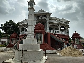
Nareli Jain Temple or Shri Gyanodaya Tirth Kshetra, is a new Jain temple located on the outskirts of Ajmer 7 kilometers from the city center and 128 kilometers west of Jaipur on the main national highway 8.
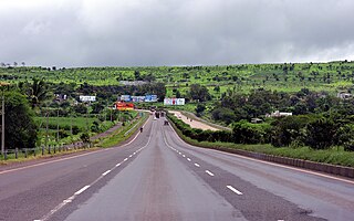
National Highway 48 is a major National Highway of India that starts at Delhi and terminates at Chennai traversing through seven states of India. It has a total length of 2807 km. NH 48 passes through the states of Delhi, Haryana, Rajasthan, Gujarat, Maharashtra, Karnataka and Tamil Nadu. The stretch between Pune and Bengaluru was known as P.B. Road in olden days.
Koshithal is a Gram Panchayat and Village Located in Sahara tehsil, nearby Gangapur town in Bhilwara District of Ajmer division in the Indian State of Rajasthan. It is located in Raipur Vidhan Sabha which governed by MLA Gayatri Kailash Trivedi Of Indian National Congress. Koshithal is largest and one of the most important Gram Panchayat in Bhilwara District. As of 2011, the population of Koshithal is 7153 having almost 1447 households. It is located 300 kms southwest of the state capital Jaipur and 60 kms away from District Headquarter Bhilwara. The village have historically rich history contemporary with Maharana Pratap. It is known for Koshithal Fort and for public cemetery where many War Martyr cremated. It is belief that Koshithal has large number of War Martyr Cremated in Local Cemetery after Chittaurgarh in Rajasthan.
Banseli is a village in Ajmer tehsil of Ajmer district of Rajasthan state in India.The village falls under Deo nagar gram panchayat.
Chawandiya is a village in Ajmer tehsil of Ajmer district of Rajasthan state in India. The village falls under Ganahera gram panchayat.
Danta is a village in Ajmer tehsil of Ajmer district of Rajasthan state in India. The village falls under Danta gram panchayat.

Kotputli-Behror is a district in the state of Rajasthan. This district was carved out from erstwhile Jaipur district and Alwar district and was formally established on 7 August 2023. It is located in north-eastern part of Rajasthan. The districts is surrounded on three sides with Aravali Ranges with Sabi river flowing through it. It comprises Tehsils of Kotpulti, Behror, Neemrana, Bansur, Mandhan, Paota, Viratnagar and Narayanpur. District headquarters are jointly located at Behror and Kotputli. Piyadasi as name of Emperor Ashoka was found out form the Bhabru rock edicts found in the district. A major part of the district comprising Tehsils of Behror, Neemrana, Bansur, Mandhan and is referred to as Rath Region though Mundawar tehsil of Rath region was made part of separate district of Khairthal.

