Balaji Baji Rao, often referred to as Nana Saheb I, was the 8th Peshwa of the Maratha Confederacy. He was appointed as Peshwa in 1740 upon the death of his father, the Peshwa Bajirao I.

Maharaja Suraj Mal, simply known as Suraj Mal, was a Jat ruler of Bharatpur State in the present-day state of Rajasthan. He is Known for his military prowess and administrative acumen, he established a prosperous kingdom in the region now encompassing parts of Rajasthan, Uttar Pradesh, and Haryana. Under him, Bharatpur State, a tributary of the House of Scindia, covered the present-day districts of Agra, Alwar, Aligarh, Bharatpur, Dholpur, Etawa, Hathras, Mainpuri, Meerut, Ghaziabad, Mathura, and Rohtak, Sonipat, Jhajjar, Nuh, Palwal, Faridabad, Kasganj, Mainpuri, Firozabad, Bulandshahr.

Chhatri are semi-open, elevated, dome-shaped pavilions used as an element in Indo-Islamic architecture and Indian architecture. They are most commonly square, octagonal, and round.
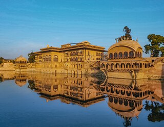
Deeg is an ancient historical city in Deeg district of Rajasthan, India. It is carved out from its former district bharatpur on 7 August 2023. It is situated 32 kilometres (20 mi) north of Bharatpur and 98 kilometres (61 mi) northwest of Agra.

Ahilyabai Holkar, also spelled Ahalya Bai, was the Rajamata and later the ruling queen of Indore within the Maratha Confederacy. She established Maheshwar as the seat of the Holkar Dynasty. A beloved figure of Indian history, she is renowned for good governance, social welfare, and humanitarian work along with religious, educational, and cultural advancements. She contributed to the growth of Indian architecture through the commission of various temples, Ghats, and Dharmshalas. Ahilyabai's Matha, or charitable endowments, spread across India. Remembered as a Sadhvi, or holy woman,
Govardhan also called Giriraj, is a key pilgrimage centre in India and a municipal town; a nagar panchayat; seat of an MLA of Uttar Pradesh; a Tehsil, in Mathura district in India in the state of Uttar Pradesh. About 23 kilometres from Mathura, the town is on the road link between Mathura and Deeg.

Malhar Rao Holkar was a noble subedar of the Maratha Empire, in present-day India. He was one of the early officers along with Ranoji Scindia to help spread the Maratha rule to northern states and was given the estate of Indore to rule by the Peshwas, during the reign of the Maratha emperor Shahu I. He was founder of the Holkar dynasty that ruled Malwa.

The Fort of Gwalior or the Gwalior Fort is a defence hill fort in Gwalior, India. Mughal Emperor Babur called it the "pearl amongst the fortresses of Hind" because of its impregnability and magnificence and it has also been nicknamed the Gibraltar of India. The history of the fort goes back to the 5th century or perhaps to a period still earlier. The old name of the hill as recorded in ancient Sanskrit inscriptions is Gopgiri. The current structure of the fort has existed at least since the 8th century, and the inscriptions and monuments found within what is now the fort campus indicate that it may have existed as early as the beginning of the 6th century, making it one of India's oldest defence forts still in existence. The modern-day fort, embodying a defensive structure and two palaces was built by the Tomar Rajput ruler Man Singh Tomar. It has witnessed the varying fortunes of the Guptas, the Hunas, the Pratiharas, the Kachhwahas, the Tomaras, the Pathans, the Surs, the Mughals, the English, the Jats, and the Marathas represented by the powerful Scindia dynasty who have left their landmarks in the various monuments which are still preserved.

Ballabgarh, officially Balramgarh, is a large town, nearby Faridabad city and a tehsil (subdistrict) in Faridabad district of Haryana, India, and is part of the Delhi National Capital Region or Delhi NCR.

Maharaja Jawahar Singh was the ruler of the Bharatpur State. He succeeded to the throne when his father Maharaja Suraj Mal Ji died in 1763.

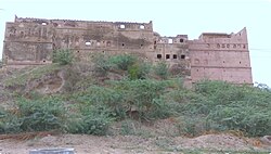
Lohagarh Fort is a fort located at Bharatpur in Rajasthan, India. It stands as a testament to the strength and ingenuity of the Jat rulers of Bharatpur, particularly Maharaja Suraj Mal, who commissioned its construction in 1732. The British army attempted to conquer this fort 13 times but they could not penetrate the fort even once. The inaccessible Lohagarh fort could withstand repeated attacks of British forces led by Lord Lake during The Siege of Bharatpur in 1805 when they laid siege for over six weeks, yet failed in all four attempts to storm the fortress.

Sadashivrao Bhau Bhatt was son of Chimaji Appa and Rakhmabai and the nephew of Baji Rao I. He was a finance minister during the reign of Maratha king Rajaram II. He led the Maratha army at the Third Battle of Panipat.

Bharatpur State was a Princely state under British suzerainty that was ruled by the Sinsinwar clan of the Hindu Jats. At the time of reign of king Suraj Mal (1755–1763) revenue of the state was 17,500,000 Gold coin per annum. The major architecture of this state include Lohagarh Fort and Deeg Palace.

Feroze Jung III or Nizam Shahabuddin Muhammad Feroz Khan Siddiqi Bayafandi also known by his sobriquet Imad-ul-Mulk, was the grand vizier of the Mughal Empire.
The Great Maratha is an Indian historical drama television series directed by Sanjay Khan and produced by Numero Uno International Limited. The drama aired on DD National. The series is based on the life of Mahadaji Shinde. The show comprised 47 episodes. The music was composed by Mohammed Zahur Khayyam.
Khanderao Holkar was the only son of Malhar Rao Holkar, the founder of the Holkar dynasty of Indore, and Gautama Bai. He was the husband of Ahilyabai Holkar. He served as a Maratha Sardar and fought several campaigns on behest of the Maratha empire.
The Safdarjung's rebellion occurred on 10 March 1753 during the waning years of the Mughal Empire. It was characterized by a conflict between Safdarjung, the Nawab of Oudh, and the Mughal emperor Ahmad Shah Bahadur, alongside his court factions.

The Capture of Agra Fort ended a month-long siege by Maharaja Suraj Mal on 12 June 1761. After a one-month siege of Agra the Mughal army, led by Mirza Fazilka Khan, surrendered to the Jat army. The Jat possessed himself of all the wealth of the Mughal Empire and thus became one of the richest man on the planet. The Jats seized the old capital of Mughal Empire. It remained in possession of Bharatpur State rulers until 1774.
The battle of Kumher was fought among Jats, Marathas and Mughals.