The following outline is provided as an overview of and topical guide to Rajasthan:
Contents
- General reference
- Names
- Rankings (amongst India's states)
- Geography of Rajasthan
- Location of Rajasthan
- Environment of Rajasthan
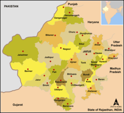
- Regions of Rajasthan
- Demography of Rajasthan
- Government and politics of Rajasthan
- Branches of the government of Rajasthan
- Law and order in Rajasthan
- History of Rajasthan
- History of Rajasthan, by period
- History of Rajasthan, by region
- History of Rajasthan, by subject
- Culture of Rajasthan
- Art in Rajasthan
- Language in Rajasthan
- Sports in Rajasthan
- Symbols of Rajasthan
- Economy and infrastructure of Rajasthan
- Education in Rajasthan
- Health in Rajasthan
- See also
- References
- External links
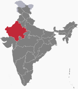
Rajasthan largest state of the Republic of India by area, is located in the northwest of India. It comprises most of the area of the large, inhospitable Thar Desert, also known as the Great Indian Desert, which parallels the Sutlej-Indus river valley along its border with Pakistan to the west. Rajasthan is also bordered by Gujarat to the southwest, Madhya Pradesh to the southeast, Uttar Pradesh and Haryana to the northeast and Punjab to the north. Rajasthan covers 10.4% of India, an area of 342,239 square kilometres (132,139 sq mi).