List of states and union territories of India by population

Last updated

India is a union consisting of 28 states and 8 union territories. [1] As of 2022, with an estimated population of 1.4 billion, India is the world's most populous country. India occupies 2.4% of the world's area and is home to 17.5% of the world's population. [2] The Indo-Gangetic Plain has one of the world's biggest stretches of fertile not-deep alluvium and are among the most densely populated areas of the world. The eastern and western coastal regions of Deccan Plateau are also densely populated regions of India. The Thar Desert in western Rajasthan is one of the most densely populated deserts in the world. [3] The northern and north-eastern states along the Himalayas contain cold arid deserts with fertile valleys. These states have relatively low population density due to indomitable physical barriers. [4]

Contents

Census of India

2001 India population density map India population density map en.svg
2001 India population density map

The first population census in British India was conducted in 1872. Since India's independence in 1947, a census has been conducted every 10 years, the first occurring in 1951. [5] The census in India is conducted by the Office of the Registrar General and Census Commissioner under the Ministry of Home Affairs, and is one of the largest administrative tasks conducted by a federal government. [6]

The latest population figures are based on data from the 2011 census of India. [7] During the decade of 20012011, India's annual population growth rate has slowed down from 2.15 percent to 1.76 percent. [7] Based on decennial census data, Dadra and Nagar Haveli and Daman and Diu has the fastest growth rate of 55.1 percent, followed by Meghalaya (27.8 percent) and Arunachal Pradesh (25.9 percent). Nagaland recorded the lowest growth rate of -0.5 percent. [8]

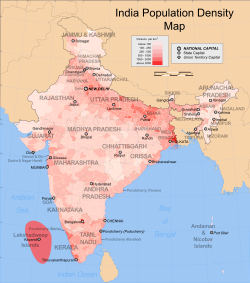
India has 641,000 inhabited villages and 72.2 percent of the total population reside in these rural areas. [8] Of them 145,000 villages have population size of 500999 persons; 130,000 villages have population size of 10001999 and 128,000 villages have population size of 200499. There are 3,961 villages that have a population of 10,000 persons or more. [9] India's 27.8 percent urban population lives in more than 5,100 towns and over 380 urban agglomerations. [10] In the decade of 19912001, migration to major cities caused rapid increase in urban population. [11] [12] On the basis of net migrants by last residence during the past decade, Maharashtra had most immigration with 2.3 million, followed by National Capital Territory of Delhi (1.7 million), Gujarat (0.68 million) and Haryana (0.67 million). Uttar Pradesh (2.6 million) and Bihar (1.7 million) topped the list for interstate emigration. [13] The five states of Uttar Pradesh, Maharashtra, Bihar, West Bengal and Madhya Pradesh account for almost half (47.90 percent) of the total Indian population. [7]

While the national average for the sex ratio shows an increase from 933 in 2001 to 940 in 2011, [7] the 2011 census shows a sharp decline in the child sex ratio, the number of females per thousand males in a population between age group 06 years. [7] States such as Punjab, Haryana, Himachal Pradesh, Gujarat, Tamil Nadu, Mizoram and Andaman and Nicobar Islands recorded an increase in India's child sex ratio. [7] The national child sex ratio has declined from 927 in 2001 to 914 in 2011. [7] Telangana census was separated from Andhra Pradesh state census figures, after Telangana was officially formed on 2 June 2014. [14]

List

Data from Census 2011 as published by the Registrar General & Census Commissioner, [15] Government of Telangana, [16] and then Planning Commission. [17]

(Population density is rounded to the nearest integer)

List of states and union territories of India by population
(2011 Census of India)
RankState or Union TerritoryPopulation
[18] [19]
%
India
Growth
(2001-2012)
2023 Population
estimate [20]
Rural pop.Urban pop.Density
[ clarification needed ]
[lower-alpha 1]
Sex ratio
[ clarification needed ]
Seats
Nos. %Nos. % Lok Sabha Rajya Sabha
1 (S1) Uttar Pradesh 199,812,34120.2%235,687,000155,317,27844,495,0638289128031
2 (S2) Maharashtra 112,374,33316%126,385,00061,556,07450,818,2593659294819
3 (S3) Bihar 104,099,45225.4%126,756,000 [lower-alpha 2] 92,341,43611,758,0161,1029184016
4 (S4) West Bengal 91,276,11513.8%99,084,00062,183,11329,093,0021,0299534216
5 (S5) Madhya Pradesh 72,626,80920.3%86,579,00052,557,40420,069,4052369312911
6 (S6) Tamil Nadu 72,147,03015.6%76,860,00037,229,59034,917,4405559963918
7 (S7) Rajasthan 68,548,43721.3%81,025,00051,500,35217,048,0852019282510
8 (S8) Karnataka 61,095,29715.6%67,692,00037,469,33523,625,9623199732812
9 (S9) Gujarat 60,439,69219.3%71,507,00034,694,60925,745,0833089192611
10 (S10) Andhra Pradesh 49,577,103 [lower-alpha 3] 11.0%53,156,00034,966,69314,610,4103039932511
11 (S11) Odisha 41,974,21914.0%46,276,00034,970,5627,003,6562699792110
12 (S12) Telangana 35,003,67413.58%38,090,00021,395,00913,608,665312988177
13 (S13) Kerala 33,406,0614.9%35,776,00017,471,13515,934,9268591,084209
14 (S14) Jharkhand 32,988,13422.4%39,466,00025,055,0737,933,061414948146
15 (S15) Assam 31,205,57617.1%35,713,00026,807,0344,398,542398958147
16 (S16) Punjab 27,743,33813.89%30,730,00017,344,19210,399,146551895137
17 (S17) Chhattisgarh 25,545,19822.6%30,180,00019,607,9615,937,237189991115
18 (S18) Haryana 25,351,46219.9%30,209,00016,509,3598,842,103573879105
19 (UT1) NCT of Delhi 16,787,94121.2%21,359,000419,04216,368,89911,29786873
20 (UT2) Jammu and Kashmir 12,267,03223.6%13,603,0009,064,2203,202,81229789054
21 (S19) Uttarakhand 10,086,29218.8%11,637,0007,036,9543,049,33818996353
22 (S20) Himachal Pradesh 6,864,60212.9%7,468,0006,176,050688,55212397243
23 (S21) Tripura 3,673,91714.8%4,147,0002,712,464961,45335096021
24 (S22) Meghalaya 2,966,88927.9%3,349,0002,371,439595,45013298921
25 (S23) Manipur [lower-alpha 4] 2,570,39024.5%3,223,0001,793,875776,51512299221
26 (S24) Nagaland 1,978,502−0.6%2,233,0001,407,536570,96611993111
27 (S25) Goa 1,458,5458.2%1,575,000551,731906,81439497321
28 (S26) Arunachal Pradesh 1,383,72726.0%1,562,0001,066,358317,3691793821
29 (UT3) Puducherry 1,247,95328.1%1,646,000395,200852,7532,5981,03711
30 (S27) Mizoram 1,097,20623.5%1,238,000525,435571,7715297611
31 (UT4) Chandigarh 1,055,45017.2%1,231,00028,9911,026,4599,2528181 [lower-alpha 5]
32 (S28) Sikkim 610,57712.9%689,000456,999153,5788689011
33 (UT5) Dadra and Nagar Haveli and Daman and Diu 585,76455.1%1,263,000243,510342,2549707112 [lower-alpha 6]
34 (UT6) Andaman and Nicobar Islands 380,5816.9%403,000237,093143,488468761 [lower-alpha 7]
35 (UT7) Ladakh 274,00017.8%300,00043,840230,1602.88531 [lower-alpha 8]
36 (UT8) Lakshadweep 64,4736.3%69,00014,14150,3322,0139461 [lower-alpha 9]
TotalIndia1,210,569,573100%17.7%1,388,163,000833,463,44868.84%377,106,12531.16%382943543245
(233+12) [lower-alpha 10]

Notes

  1. For determining population density of India and the State of Jammu and Kashmir, the data excludes areas claimed by India but controlled by Pakistan (78,114 km2) and China (5,180 km2 in Shaksgam Valley and 37,555 km2 under Aksai Chin and other areas). [21] [22]
  2. population of caste census finished in Oct 2023 was 130.7 million [23]
  3. Calculated by subtracting the population of Telangana from Andhra Pradesh's Census 2011 figures.
  4. Excludes Mao-Maram, Paomata, and Purul sub-divisions of Senapati district of Manipur.
  5. No state legislature
  6. No state legislature
  7. No state legislature
  8. No state legislature
  9. No state legislature
  10. Includes 12 Presidential nominations

See also

Related Research Articles

<span class="mw-page-title-main">Demographics of India</span>

India is the most populous country in the world with one-sixth of the world's population. According to estimates from the United Nations (UN), India has overtaken China as the country with the largest population in the world, with a population of 1,425,775,850 at the end of April 2023.

<span class="mw-page-title-main">Chhattisgarh</span> State in central India

Chhattisgarh is a landlocked state in Central India. It is the ninth largest state by area, and with a population of roughly 30 million, the seventeenth most populous. It borders seven states – Uttar Pradesh to the north, Madhya Pradesh to the northwest, Maharashtra to the southwest, Jharkhand to the northeast, Odisha to the east, Andhra Pradesh and Telangana to the south. Formerly a part of Madhya Pradesh, it was granted statehood on 1 November 2000 with Raipur as the designated state capital.

<span class="mw-page-title-main">East Godavari district</span> District of Andhra Pradesh in India

East Godavari is a district in the Coastal Andhra region of Andhra Pradesh, India. Its district headquarters is at Rajamahendravaram.

<span class="mw-page-title-main">Bagpat district</span> District of Uttar Pradesh in India

Bagpat district, also spelled as Baghpat district, is one of the 75 districts of the Indian state of Uttar Pradesh, with headquarters at the town of Baghpat. It is within the National Capital Region. Created in 1997, the district has an area of 1,321 square kilometres (510 sq mi). Bhagpat has a population of 1,303,048 as of 2011 census.

<span class="mw-page-title-main">Betul district</span> District of Madhya Pradesh in India

Betul district is a district of Madhya Pradesh state in central India. The city of Betul serves as its administrative headquarters. The district is a part of Narmadapuram Division.

<span class="mw-page-title-main">Vizianagaram district</span> District of Andhra Pradesh in India

Vizianagaram district is one of the six districts in the Uttarandhra region of the Indian state of Andhra Pradesh with its headquarters located at Vizianagaram. The district was once the part of ancient Kalinga.Saripilli Dibbilingeswara temple, Jayathi Mallikarjuna Temple are the finest examples of ancient Eastern Ganga Dynasty built monuments in the district. The district is bounded on the east by the district of Srikakulam, north by Parvathipuram Manyam south by Visakhapatnam, Anakapalli, southeast by the Bay of Bengal, and west by Alluri Sitharama Raju district. It was formed on 1 June 1979, with some parts carved from the neighbouring districts of Srikakulam and Visakhapatnam. The district is named after the princely state of Vizianagaram. In 2011, it was the least populous district in Andhra Pradesh.

<span class="mw-page-title-main">Panna district</span> District of Madhya Pradesh in India

Panna district is a district of the Sagar Division, within the Madhya Pradesh state in central India. The town of Panna is the district headquarters.

<span class="mw-page-title-main">Jhabua district</span> District of Madhya Pradesh in India

Jhabua is a district of Madhya Pradesh state in central India. The town of Jhabua is the administrative headquarters of the district.

<span class="mw-page-title-main">Ranga Reddy district</span> District of Telangana in India

Ranga Reddy district is a district in the Indian state of Telangana. The district headquarters is located at Kongara Kalan Village, Ibrahimpatnam Mandal,. The district was named after the former deputy chief minister of the United Andhra Pradesh, K. V. Ranga Reddy. The district shares boundaries with Nalgonda, Yadadri Bhuvanagiri, Hyderabad, Medchal–Malkajgiri, Nagarkurnool, Mahabubnagar, Sangareddy and Vikarabad districts.

<span class="mw-page-title-main">Meerut district</span> District of Uttar Pradesh in India

Meerut district, is one of the districts of Uttar Pradesh state of India, with the city of Meerut as the district headquarters. Meerut district is also a part of the Meerut division. The administrative head of district of Meerut is a District Magistrate while the administrative head of Meerut Division is Divisional Commissioner, an IAS officer.

Developed village

<span class="mw-page-title-main">Satna district</span> District of Madhya Pradesh in India

Satna District is a district of Madhya Pradesh state in central India. The city of Satna is the district headquarters. The district has an area of 7,502 km2, and a population of 22,28,935(2011 census), 20.63% of which is urban. The district has a population density of 249 persons per km2.

Punjab is home to 2.3% of India's population; with a density of 551 persons per km2. According to the provisional results of the 2011 national census, Punjab has a population of 27,743,338, making it the 16th most populated state in India. Of which male and female are 14,639,465 and 13,103,873 respectively. 32% of Punjab's population consists of Dalits. In the state, the rate of population growth is 13.9% (2011), lower than national average. Out of total population, 37.5% people live in urban regions. The total figure of population living in urban areas is 10,399,146 of which 5,545,989 are males and while remaining 4,853,157 are females. The urban population in the last 10 years has increased by 37.5%. According to the 2011 Census of India, Punjab, India has a population of around 27.7 million.

<span class="mw-page-title-main">Bijapur district, Chhattisgarh</span> District of Chhattisgarh in India

Bijapur District, formerly known as Birjapur, is one of the 27 districts of the state of Chhattisgarh in central India. It is one of the two new districts created on May 11, 2007. As of 2011 it is the second least populous district of Chhattisgarh, after Narayanpur. It is the second-least literate district in India, with a literacy rate of at 41.58%, according to the 2011 census.

Andhra Pradesh is one of the southern state of India. There are a total of 26 districts in the three regions of Coastal Andhra, Uttarandhra and Rayalaseema. The capital of the state is the Amaravati. However, a proposal to establish three capitals at vishakapatnam(executive capital), amravati and kurnool is still being considered.

Telangana state is the 12th most populous state in India, with a population of 35,003,674 as per 2011 Census, with a population density of 312 per km2. The state has male and female population of 17,611,633 and 17,392,041 respectively with sex ratio standing at 988. Decadal Growth Rate (2001-2011) Rate is 13.58%.

<span class="mw-page-title-main">Bhadradri Kothagudem district</span> District in Telangana, India

Bhadradri Kothagudem is a district in the east of the Indian state of Telangana. Kothagudem is the district headquarters. It is the largest district in Telangana, with an area of 7483 km2. It borders the districts Khammam, Mahabubabad, Mulugu, Eluru and East Godavari, and shares a boundary with the bordering states Chhattisgarh and Andhra Pradesh. The district comprises 24 mandals and 2 revenue divisions, Kothagudem and Bhadrachalam.

<span class="mw-page-title-main">Jogulamba Gadwal district</span> District of Telangana in India

Jogulamba Gadwal district is a district in the Indian state of Telangana. The administrative headquarters of the district is located at Gadwal. The district shares boundaries with Narayanpet, Wanaparthy districts and with the state boundary of Andhra Pradesh and Karnataka. The district was carved out from Mahabubnagar district in 2016.

References

  1. "National Portal of India". www.india.gov.in. Retrieved 2022-08-08.
  2. "Census and you - Area And Population". 2007-12-26. Archived from the original on 26 December 2007. Retrieved 2022-08-08.
  3. "Report of the Task Force on Grasslands and Deserts" (PDF). 2011-12-10. Archived from the original (PDF) on 10 December 2011. Retrieved 2022-08-08.
  4. "India - General Profile, Land Use Classification and Land Use Pattern" (PDF). 2006-05-14. Archived from the original (PDF) on 14 May 2006. Retrieved 2022-08-08.
  5. "Census Organisation of India". Government of India (2001). Census of India. Archived from the original on December 1, 2008. Retrieved 2008-12-04.
  6. "Brief history of census". Government of India (2001). Census of India. Archived from the original on 2013-11-13. Retrieved 2008-10-26.
  7. 1 2 3 4 5 6 7 "India Census 2011, Provisional Population Totals". The Hindu. Chennai, India.[ dead link ]
  8. 1 2 "Archived copy" (PDF). The Hindu . Archived from the original (PDF) on 2013-11-03.{{cite web}}: CS1 maint: archived copy as title (link)
  9. "Area and Population". Government of India (2001). Census of India. Archived from the original on 2007-12-26. Retrieved 2008-10-26.
  10. "Urban Agglomerations (UAs) & towns". Government of India (2001). Census of India. Archived from the original on 2013-11-13. Retrieved 2008-12-04.
  11. Shinde, Swati (13 Sep 2008). "Migration rate to city will dip". The Times of India . Archived from the original on 5 November 2012. Retrieved 2008-12-08.
  12. "Develop towns to stop migration to urban areas: economist". The Hindu . Chennai, India. Dec 3, 2005. Archived from the original on December 5, 2005. Retrieved 2008-12-08.
  13. "Migration". Government of India (2001). Census of India. Archived from the original on 2013-11-13. Retrieved 2008-10-26.
  14. "T-party today: India's 29th state Telangana is born - Times of India ►". The Times of India . 2 June 2014. Archived from the original on 17 September 2018. Retrieved 15 September 2018.
  15. "Population and decadal change by residence : 2011 (PERSONS)" (PDF). Office of the Registrar General & Census Commissioner, India. p. 2. Archived (PDF) from the original on 2016-06-24. Retrieved 2019-01-15.
  16. "Statistical Year Book 2015" (PDF). telangana.gov.in. Directorate of Economics and Statistics, Government of Telangana. Archived (PDF) from the original on 19 October 2019. Retrieved 4 March 2019.
  17. "Census 2011 (Final Data) - Demographic details, Literate Population (Total, Rural & Urban)" (PDF). planningcommission.gov.in. Planning Commission, Government of India. Archived from the original (PDF) on 27 January 2018. Retrieved 15 January 2019.
  18. "List of states with Population, Sex Ratio and Literacy Census 2011". www.census2011.co.in. Retrieved 2023-04-30.
  19. "Census 2011: Population in States and Union Territories of India". Jagranjosh.com. 2016-10-14. Retrieved 2023-04-30.
  20. "Indian states 2023 population estimates". www.main.mohfw.gov.in. 2023-12-01. Retrieved 2024-03-29.
  21. "J&K 2011 Population density census" (PDF). Archived from the original on 2018-12-25. Retrieved 2022-01-06.
  22. "Religion PCA 2011 J&K census". Archived from the original on 2016-02-09. Retrieved 2016-01-14.
  23. "Bihar's Caste Census: A Game-Changer in Indian Politics!". 3 October 2023.