
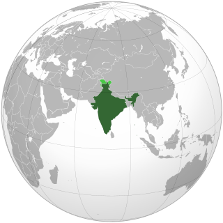
This is a list of states and territories of India by number of places of worship as reported by the Census 2001. Uttar Pradesh has highest number of places of worship.
This is a list of states and territories of India by number of places of worship as reported by the Census 2001. Uttar Pradesh has highest number of places of worship.
| Rank | State / Territory | Number of Places of Worship | References |
|---|---|---|---|
| | 2,366,625 | ||
| 1 | Uttar Pradesh | 265,270 | [1] |
| 2 | West Bengal | 228,452 | [2] |
| 3 | Maharashtra | 220,458 | [3] |
| 4 | Karnataka | 207,332 | [4] |
| 5 | Rajasthan | 166,766 | [5] |
| 6 | Andhra Pradesh | 159,025 | [6] |
| 7 | Madhya Pradesh | 142,452 | [7] |
| 8 | Gujarat | 142,135 | [8] |
| 9 | Bihar | 138,493 | [9] |
| 10 | Tamil Nadu | 130,346 | [10] |
| 11 | Odisha | 103,350 | [11] |
| 12 | Kerala | 101,140 | [12] |
| 13 | Assam | 90,194 | [13] |
| 14 | Jharkhand | 50,110 | [14] |
| 15 | Punjab | 46,493 | [15] |
| 16 | Chhattisgarh | 46,095 | [16] |
| 17 | Himachal Pradesh | 26,526 | [17] |
| 18 | Uttarakhand | 25,959 | [18] |
| 19 | Haryana | 24,519 | [19] |
| 20 | Tripura | 12,872 | [20] |
| 21 | Delhi | 8,249 | [21] |
| 22 | Meghalaya | 5,771 | [22] |
| 23 | Goa | 5,686 | [23] |
| 24 | Manipur | 5,251 | [24] |
| 25 | Mizoram | 3,154 | [25] |
| 26 | Arunachal Pradesh | 2,363 | [26] |
| 27 | Nagaland | 2,360 | [27] |
| 28 | Puducherry | 2,146 | [28] |
| 29 | Andaman and Nicobar Islands | 1,121 | [29] |
| 30 | Sikkim | 1,049 | [30] |
| 31 | Daman and Diu | 477 | [31] |
| 32 | Lakshadweep | 430 | [32] |
| 33 | Chandigarh | 340 | [33] |
| 34 | Jammu and Kashmir | ||
| 35 | Dadra and Nagar Haveli | 241 | [34] |
| 36 | Ladakh | ||

Uttar Pradesh is a state in northern India. With over 200 million inhabitants, it is the most populated state in India as well as the most populous country subdivision in the world. It was established in 1950 after India had become a republic. It was a successor to the United Provinces (UP) during the period of the Dominion of India (1947–1950), which in turn was a successor to the United Provinces (UP) established in 1935, and eventually of the United Provinces of Agra and Oudh established in 1902 during the British Raj. The state is divided into 18 divisions and 75 districts, with the state capital being Lucknow, and Prayagraj serving as the judicial capital. On 9 November 2000, a new state, Uttaranchal, was created from Uttar Pradesh's western Himalayan hill region. The two major rivers of the state, the Ganges and its tributary Yamuna, meet at the Triveni Sangam in Prayagraj, a Hindu pilgrimage site. Other notable rivers are Gomti and Saryu. The forest cover in the state is 6.1 per cent of the state's geographical area. The cultivable area is 82 per cent of total geographical area and net area sown is 68.5 per cent of cultivable area.

The Gondi (Gōndi) or Gond or Koitur are a Dravidian ethnolinguistic group. They are one of the largest tribal groups in India. They are spread over the states of Madhya Pradesh, Maharashtra, Chhattisgarh, Uttar Pradesh, Telangana, Andhra Pradesh, Bihar, Assam, Arunachal Pradesh, Uttarakhand and Odisha. They are listed as a Scheduled Tribe for the purpose of India's system of reservation. The Gond have formed many kingdoms of historical significance.

Dhobi known in some places as Dhoba or Rajaka, Madivala is a group of community in India and the greater Indian subcontinent whose traditional occupations are washing and ironing, Cultivator, agricultural workers.
Mubarakpur is a town and a municipal board in Azamgarh district in the Indian state of Uttar Pradesh. It is located at a distance of 13 km north-east of the district headquarters in Azamgarh.

Gautam Buddha Nagardistrict is a district of Uttar Pradesh, named after Gautama Buddha. It is a part of Delhi NCR and is divided into 4 sub-divisions i.e. Noida, Greater Noida, Dadri and Jewar. Greater Noida is the administrative headquarters of Gautam Buddha Nagar district. Noida, Greater Noida, Dadri, Jewar and Dankaur falls under this district.

The Korwa people are a Munda, a Scheduled Tribe ethnic group of India. They live mainly on the border between Chhattisgarh and Jharkhand. A small number of Korwa are also found in the Mirzapur district of Uttar Pradesh.

Kunda is a town and a Tehsil in Pratapgarh district in the Indian state of Uttar Pradesh.
Telephone numbers in India are administered under the National Numbering Plan of 2003 by the Department of Telecommunications of the Government of India. The numbering plan was last updated in 2015. The country code "91" was assigned to India by the International Telecommunication Union in the 1960s.
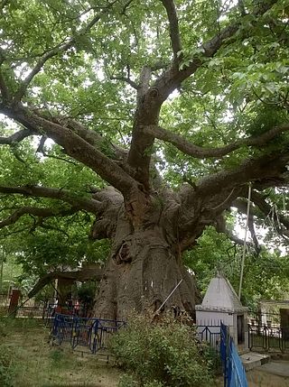
The Parijaat tree is a sacred baobab tree in the village of Kintoor, near Barabanki, Uttar Pradesh, India, about which there are several legends.
The Muslim Kayastha, a community of Muslims, are related to the Kayastha of northern India, mainly modern Uttar Pradesh, who converted to Islam during the rule of the Islamic empires in India. The Muslim Kayastha and Nagar Muslims of Uttar Pradesh are considered Shaikh and follow Sunni Hanafi fiqh. The Muslim Kayasths have intermarried with other Muslim communities over the centuries, lost their community consciousness, and consider themselves Urdu speaking Muslims of Pakistan and northern India.
The Sahariya are a community found in the Bundelkhand region of North India, which is administered by the states of Madhya Pradesh and Uttar Pradesh. They are also known as Rawat, Banrawat, Banrakha and Soarain.

Fatehpur District is one of the 75 districts of the Indian state of Uttar Pradesh. The district covers an area of 4,152 km2. The district has a population of 2,632,733. Fatehpur city is the administrative headquarters of the district. Located on the banks of the sacred rivers Ganges and Yamuna, Fatehpur was mentioned in the puranic literature. The ghats of Bhitaura and Asani were described as sacred in the puranas. Bhitaura, the site of the sage Bhrigu, was an important source of learning. Fatehpur district is a part of Allahabad division.

Kushinagar is a town in the Kushinagar district in Uttar Pradesh, India. It is an important and popular Buddhist pilgrimage site, where Buddhists believe Gautama Buddha attained Parinirvana.
In religion and spirituality, a pilgrimage is a very long journey or search of great moral significance. Sometimes, it is a journey to a sacred area or shrine of importance to innate faith. Members of every major religion participate in pilgrimages. A person who makes such a journey is called a pilgrim.
Bareilly Assembly constituency is one of the 403 constituencies of the Uttar Pradesh Legislative Assembly, India. It is a part of the Bareilly district and one of the five assembly constituencies in the Bareilly Lok Sabha constituency. First election in this assembly constituency was held in 2012 after the "Delimitation of Parliamentary and Assembly Constituencies Order, 2008" was passed and the constituency was formed in 2008. The constituency is assigned identification number 124. And Baheri town is the largest Tahseel of zila Bareilly, settled with Muslim Majority. Meena Bazar is a famous place in Baheri and known around the other places as a great hub for Ladies' shopping. VVPAT facility with EVMs will be here in the 2017 U.P assembly polls.

The Jain Temple complex is group of 31 Jain temples located at Deogarh in Lalitpur district, Uttar Pradesh built around 8th to 17th century CE. The Jain complex in Deogarh are protected by the Department of Archaeology of the Archaeological Survey of India (ASI), and managed through its Northern Circle Office located in Lucknow. ASI maintain an archaeological museum at the Deogarh site, which is noted for its treasured archaeological sculptures.
Bilgram-Mallanwan is a constituency of the Uttar Pradesh Legislative Assembly covering the city of Bilgram & Mallanwan in the Hardoi district of Uttar Pradesh, India. Bilgram-Mallanwan is one of five assembly constituencies in the Misrikh Lok Sabha constituency. Since 2008, this assembly constituency is numbered 159 amongst 403 constituencies. This place is famously controversial in its region.

Ataura Khurd is a village in Sataon block of Rae Bareli district, Uttar Pradesh, India. It is located 15 km from Raebareli, the district headquarters. As of 2011, its population is 2,118, in 390 households. It has one primary school and no healthcare facilities. Ataura Khurd hosts a festival to Durga Devi on Vaisakha Badi 4-11 and Kartika Badi 4-11 dedicated to the worship of the goddess. Vendors bring sweets, toys, and various everyday items to sell at the fair.
Didaur, also spelled Dedaur, is a village in Sataon block of Rae Bareli district, Uttar Pradesh, India. It is located 8 km from Raebareli on the road to Unnao, just east of the intersection with the road to Lalganj. It is near the right bank of the Sai river. As of 2011, Didaur has a population of 4,781 people, in 900 households. The village hosts two annual festivals: one is the Badhwapur-ka-Mela, which is dedicated to the worship of Nag Devta and is held on Bhadra Sudi 5, and the other is the Jhurhapur-ka-Mela, which is dedicated to worship of Rama and falls on Phalguna Sudi 8.

Rustampur is a village in Rahi block of Rae Bareli district, Uttar Pradesh, India. It is located 7 km from Rae Bareli, the district headquarters. As of 2011, it has a total population of 4,546 people, in 843 households. It has one primary school and one primary health centre. It serves as the headquarters of a nyaya panchayat which also includes 12 other villages.