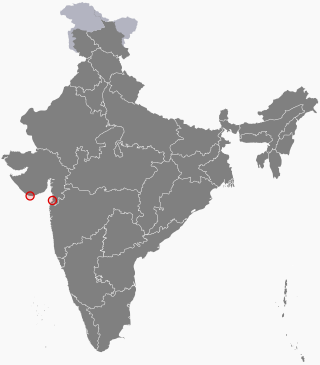
Daman and Diu was a union territory in northwestern India. With an area of 112 km2 (43 sq mi), it was the smallest administrative subdivision of India on the mainland. The territory comprised two districts, Daman and Diu island, geographically separated by the Gulf of Khambat. The state of Gujarat and the Arabian Sea bordered the territory. A Portuguese colony since the 1500s, the territories were taken by India with the Annexation of Goa in 1961. Daman and Diu were administered as part of the union territory of Goa, Daman and Diu between 1961 and 1987, after the Goa Opinion Poll they became a separate union territory. In 2019, legislation was passed to merge the union territory of Daman and Diu with its neighbouring union territory, Dadra and Nagar Haveli, to form the new union territory of Dadra and Nagar Haveli and Daman and Diu with effect from 26 January 2020.

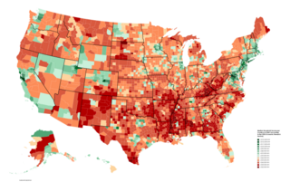
Household income is an economic standard that can be applied to one household, or aggregated across a large group such as a county, city, or the whole country. It is commonly used by the United States government and private institutions to describe a household's economic status or to track economic trends in the US.

Lalganj is a town with nagar panchayat in Raebareli district of Uttar Pradesh, India. It is located on the road from Raebareli to Fatehpur, with other roads leading to Dalmau, Unnao, and Baksar. It is developing rapidly due to the Rail Coach Factory and also has the largest railway station in the district.

The homeownership rate in the United States is the percentage of homes that are owned by their occupants. In 2009, it remained similar to that in some other post-industrial nations with 67.4% of all occupied housing units being occupied by the unit's owner. Homeownership rates vary depending on demographic characteristics of households such as ethnicity, race, type of household as well as location and type of settlement. In 2018, homeownership dropped to a lower rate than it was in 1994, with a rate of 64.2%.
Affluence refers to an individual's or household's economical and financial advantage in comparison to others. It may be assessed through either income or wealth.
Income in India discusses the financial state in India. With rising economic growth and prosperity, India's income is also rising rapidly. As an overview, India's per capita net national income or NNI was around 9.97 lakh rupees in 2022. The per-capita income is a crude indicator of the prosperity of a country. In contrast, the gross national income at constant prices stood at over 128 trillion rupees. The same year, GRI growth rate at constant prices was around 6.6 percent. While GNI and NNI are both indicators for a country's economic performance and welfare, the GNI is related to the GDP or the Gross Domestic Product plus the net receipts from abroad, including wages and salaries, property income, net taxes and subsidies receivable from abroad. On the other hand, the NNI of a country is equal to its GNI net of depreciation.

Home ownership in Australia is considered a key cultural icon, and part of the Australian tradition known as the Great Australian Dream of "owning a detached house on a fenced block of land." Home ownership has been seen as creating a responsible citizenry; according to a former Premier of Victoria: "The home owner feels that he has a stake in the country, and that he has something worth working for, living for, fighting for."

Kochas is a town and corresponding community development block in Rohtas district of Bihar state, India. It is located at an elevation of 69 m above MSL. National Highway 319 passes through Kochas. The nearest airport is Varanasi Airport (105 km).The most famous cultural event of Kochas is Krishn Lila unfortunately it is known and famous as "Kans Lila". Beside Krishn Lila other famous cultural activities are Chhath Puja, Durga Puja and other religious functions. Kochas's Surya Mandir sun temple is identity of Kochas. It is situated in center of a Pond "Pokhara". It was established on 1 October (SS).

The 2011 census of India or the 15th Indian census was conducted in two phases, house listing and population enumeration. The House listing phase began on 1 April 2010 and involved the collection of information about all buildings. Information for National Population Register (NPR) was also collected in the first phase, which will be used to issue a 12-digit unique identification number to all registered Indian residents by Unique Identification Authority of India. The second population enumeration phase was conducted between 9 and 28 February 2011. Census has been conducted in India since 1872 and 2011 marks the first time biometric information was collected. According to the provisional reports released on 31 March 2011, the Indian population increased to 1.21 billion with a decadal growth of 17.70%. Adult literacy rate increased to 74.04% with a decadal growth of 9.21%. The motto of the census was Our Census, Our Future.

Pradhan Mantri Gramin Aawas Yojana, previously Indira Awas Yojana, is a social welfare programme, created by the Indian Government, to provide housing for the rural poor in India. A similar scheme for urban poor was launched in 2015 as Housing for All by 2022. Indira Awas Yojana was launched in 1985 by Rajiv Gandhi, the Prime Minister of India, as one of the major flagship programs of the Ministry of Rural Development to construct houses for the Below Poverty Line population in the villages.

Sheosagar, also spelled Shiusagar or Shivsagar, is a village and corresponding community development block in Rohtas district of Bihar, India. As of 2011, the village of Sheosagar had a population of 2,065, in 345 households, while the entire block had a population of 176,080. The nearest major city is Sasaram, the capital of Rohtas district.

Nauhatta is a village and corresponding community development block in Rohtas district of Bihar, India. As of 2011, the village of Nauhatta had a population of 5,103, in 909 households, while Nauhatta block had a population of 94,065, in 16,387 households. The nearest city is Dehri.

Mau is a large village in Dih block of Rae Bareli district, Uttar Pradesh, India. It is located on the road from Fursatganj to the Gukana ghat on the Ganges, 4 miles west of Nasirabad and 8 miles from Jais. A road branches off at Mau and connects to Nasirabad. To the northwest of the village is a large lake called the Bara Tal.
Kiya is a large village in Dih block of Rae Bareli district, Uttar Pradesh, India. It is located 33 km from Raebareli, the district headquarters. As of 2011, it has a population of 846 people, in 141 households. It has one primary school and no healthcare facilities, and does not host a weekly haat or a permanent market. It belongs to the nyaya panchayat of Mau.
Rajauli is a village in Lalganj block of Rae Bareli district, Uttar Pradesh, India. As of 2011, it has a population of 1,915 people, in 338 households. Rajauli has no schools, healthcare facilities, weekly haat or a permanent market. It belongs to the nyaya panchayat of Bahai.

Lakhangaon is a village in Sareni block of Rae Bareli district, Uttar Pradesh, India. As of 2011, it has a population of 1,233 people, in 210 households. It has no healthcare facilities and hosts both a weekly haat and a permanent market. It belongs to the nyaya panchayat of Malkegaon.

Akhaupur is a village in Khiron block of Rae Bareli district, Uttar Pradesh, India. It is located 18 km (11 mi) from Lalganj, the tehsil headquarters. As of 2011, it has a population of 1,338 people, in 258 households. It has one primary school and no healthcare facilities and it does not host a weekly haat or a permanent market. It belongs to the nyaya panchayat of Tikwamau.

Chak Lodipur is a village in Rahi block of Rae Bareli district, Uttar Pradesh, India. It is located 8 km from Rae Bareli, the district headquarters. As of 2011, the village population is 449 people, in 89 households. It has one primary school, no medical facilities and does not host a weekly haat or a permanent market. It belongs to the nyaya panchayat of Rustampur.
