Didwana-Kuchaman district

Last updated
Didwana–Kuchaman District
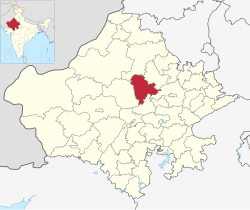
Didwana-Kuchaman in Rajasthan (India).svg
Location of Didwana Kuchaman district in Rajasthan
CountryIndia
State Rajasthan
Division Ajmer
EstablishedAugust 2023
Headquarters (temporary) Didwana
Government
  TypeDemocracy
  BodyGovernment of Rajasthan
  District Collector & MagistrateBal Mukund Asawa, IAS [1]
  Superintendent of PoliceRajendra Kumar Meena, IPS [2]
Website Deedwana-Kuchaman District

Didwana-Kuchaman is a district in the Indian state of Rajasthan. Didwana city serving as the temporary district headquarters (until a new mini secretariat is established).

Contents

History

The district was established on 7 August 2023. [3]

Demographics

Religions in Didwana Kuchaman district (2011) [4]
ReligionPercent
Hinduism
82.82%
Islam
16.52%
Jainism
0.44%
Other or not stated
0.22%

At the time of the 2011 census, Didwana-Kuchaman district had a population of 1,625,837. Didwana-Kuchaman district had a sex ratio of 954 females per 1000 males. 359,823 (22.13%) lived in urban areas. Scheduled Castes and Scheduled Tribes made up 326,713 (20.10%) and 6,798 (0.42%) of the population respectively. [5]

Hindus are the majority religion. Muslims mainly live in urban areas and are in majority in several towns such as Makrana.

Languages of Didwana Kuchaman district (2011) [6]

   Rajasthani (77.70%)
   Marwari (17.48%)
   Urdu (2.40%)
   Hindi (2.20%)
  Others (0.22%)

At the time of the 2011 census, 77.70% of the population spoke Rajasthani, 17.48% Marwari, 2.40% Urdu and 2.20% Hindi as their first language. [6]

Total population of district as per the 2011 Census of India is as follows:

Population As per Census 2011<(only 5 Tehsils Makrana, Parbatsar, Nawa, Didwana and Ladnu was present during census)
Sl NoSub DivisionTotal PopulationMale PopulationFemale Population
1Makrana345,569177,715167,884
2Didwana397,003202,303194,700
3Nawa404,910208,912195,998
4Parbatsar225,413114,898110,515
5Ladnun252,942128,390124,552
Total1,625,837832,218793,649

Tehsils

Presently Tehsils are as follows:

Sl NoSub DivisionTehsil
1Makrana1Makrana
2Didwana2Didwana
3Maulasar
4 Chhoti Khatu
3Nawa5Nawa
4Parbatsar6Parbatsar
5Ladnun7Ladnun
6Kuchaman8Kuchaman

Related Research Articles

<span class="mw-page-title-main">Agra district</span> District in Uttar Pradesh, India

Agra is one of the 75 districts in the northern Indian state of Uttar Pradesh. The district headquarters is the historical city of Agra. Agra district is a part of Agra division.

<span class="mw-page-title-main">Sawai Madhopur district</span> District of Rajasthan in India

Sawai Madhopur district is a district of Rajasthan state in north-west India. Sawai Madhopur is the chief town and district headquarters. Sawai Madhopur district comes under Bharatpur division.

<span class="mw-page-title-main">Ratlam district</span> Municipal Corporation in Madhya Pradesh, India

Ratlam District is a district of Madhya Pradesh state in central India. The town of Ratlam is administrative headquarters of the district.

<span class="mw-page-title-main">Chittorgarh district</span> District of Rajasthan, India

Chittorgarh district is one of the 50 districts of Rajasthan state in western India. The historic city of Chittaurgarh is the administrative headquarters of the district. The district was established on 1 August 1948 by integrating portions of various princely states: Mewar, Pratabgarh, Tonk, and Jhalawar. Chittaurgarh is famous for the Chittor fort, home to various famous Rajput dynasties.

<span class="mw-page-title-main">Vidisha district</span> District of Madhya Pradesh in India

Vidisha District (विदिशा) is in Madhya Pradesh state, in central India. The city of Vidisha is the administrative headquarters of the district.

<span class="mw-page-title-main">Rampur district</span> District of Uttar Pradesh in India

Rampur district is one of the districts of Uttar Pradesh state of India, and Rampur town is the district headquarters. Rampur district is a part of Moradabad division. The district occupies an area of 2,367 km2 (914 sq mi).

<span class="mw-page-title-main">Ajmer district</span> District of Rajasthan in India

Ajmer district is a district in the Indian state of Rajasthan. It is part of the Ajmer division–one of the ten administrative divisions of Rajasthan. The city of Ajmer is the district headquarters. The district is situated in the center of Rajasthan, and is bounded by Didwana Kuchaman district to the north, Jaipur Rural and Dudu to the north-east, Tonk to the east, Kekri and Beawar to the south, and Nagaur to the west. It has an area of 8,481 km2 (3,275 sq mi), and a population of 2,583,052.

<span class="mw-page-title-main">Kota district</span> District of Rajasthan in India

Kota District is a district of the state of Rajasthan in western India. The city of Kota is the administrative headquarters of the district.

<span class="mw-page-title-main">Jaipur district</span> District of Rajasthan in India

Jaipur District is a district in the state of Rajasthan in Northern India. Jaipur district is dominated by gurjar community. the city of Jaipur, which is Rajasthan's capital and the largest city, is the district headquarters. It is the tenth most populous district in India.

<span class="mw-page-title-main">Rajsamand district</span> District of Rajasthan in India

Rajsamand District is a district of the state of Rajasthan in western India. The city of Rajsamand is the district headquarters. The district was constituted on 10 April 1991 from Udaipur district by carving out 7 tehsils - Bhim, Deogarh, Amet, Kumbhalgarh, Rajsamand, Nathdwara, and Railmagra.

<span class="mw-page-title-main">Bhilwara district</span> District of Rajasthan, India

Bhilwara District is a district of the state of Rajasthan in western India. The city of Bhilwara is the district headquarters.

<span class="mw-page-title-main">Nagaur district</span> District in Rajasthan, India

Nagaur District is one of the 50 districts of the state of Rajasthan in western India. Panchayati Raj was introduced here. It is the fifth largest district in Rajasthan and the area of the district is 17,718 km2 (6,841 sq mi). The city of Nagaur is the district headquarters.

<span class="mw-page-title-main">Bikaner district</span> District of Rajasthan in India

Bikaner District is a district of the state of Rajasthan in western India. The historic city of Bikaner is the district headquarters. The district is located in Bikaner Division along with the three other districts of Anupgarh, Sri Ganganagar and Hanumangarh.

<span class="mw-page-title-main">Dholpur district</span> District of Rajasthan in India

Dholpur District is a district of Rajasthan state in Northern India. The town of Dholpur is the district headquarters. Dholpur District is a part of Bharatpur Divisional Commissionerate. It was carved out from the erstwhile Bharatpur District on 15 April 1982.

<span class="mw-page-title-main">Sikar district</span> District in Rajasthan, India

Sikar district is a district of the Indian state Rajasthan in northern India. The city Sikar is the administrative headquarters of the district. Sikar, Laxmangarh, and Fatehpur Shekahwati are the largest cities and tehsils of the district.

<span class="mw-page-title-main">Bundi district</span> District of Rajasthan in India

Bundi is a district in the state of Rajasthan in western India. The city of Bundi is the district headquarters. It has an area of 5,550 km2 and a population of 1,110,906. It is divided into 5 tehsils which are: Bundi, Hindoli, Nainwa, Keshoraipatan and Indergarh.

<span class="mw-page-title-main">Deeg district</span> District of Rajasthan in India

Deeg district is a district in Rajasthan state in northwestern India. It is bordered by Haryana to the north, Uttar Pradesh to the east, Bharatpur district to the south, and Alwar district to the west.

<span class="mw-page-title-main">Gangapur district</span> District of Rajasthan in India

Gangapur district is a district of Rajasthan State in north-west India. Gangapur City is the district headquarter. It comes under Bharatpur Division. It is one of the newest districts of Rajasthan.

Kekri is a district of the Indian state of Rajasthan. It is located in central Rajasthan. It was formally established on 7 August 2023 by the Chief Minister Ashok Gehlot, and was carved out from parts of Ajmer district and Tonk district.

<span class="mw-page-title-main">Khairthal-Tijara district</span> District of Rajasthan in India

Khairthal-Tijara district is a district of the Indian state of Rajasthan. It was carved out of erstwhile Alwar district on 4 August 2023 by Chief Minister Ashok Gelhot.

References

  1. "Didwana Kuchaman Administration". didwana-kuchaman.rajasthan.gov.in.
  2. "Didwana Kuchaman Administration". didwana-kuchaman.rajasthan.gov.in.
  3. "Rajasthan Cabinet approves formation of 19 new districts, 3 divisions in state". India Today. Retrieved 2023-10-01.
  4. "Table C-01 Population By Religion - Rajasthan". census.gov.in. Registrar General and Census Commissioner of India.
  5. "District Census Handbook 2011 - Nagaur" (PDF). Census of India . Registrar General and Census Commissioner of India.
  6. 1 2 "Table C-16 Population by Mother Tongue: Rajasthan". censusindia.gov.in. Registrar General and Census Commissioner of India.