This article possibly contains original research .(September 2021) |
Bharatpur Lohagarh City | |
|---|---|
City | |
| Coordinates: 27°13′N77°29′E / 27.22°N 77.48°E | |
| Country | |
| State | Rajasthan |
| District | Bharatpur |
| Founded by | Suraj Mal |
| Named after | Bharat- A historical warrior famous in the area |
| Government | |
| • Type | Mayor–Council |
| • Body |
|
| Area | |
• Total | 48 km2 (19 sq mi) |
| Elevation | 183 m (600 ft) |
| Population (2011) [1] | |
• Total | 252,838 |
| • Density | 5,300/km2 (14,000/sq mi) |
| Languages | |
| • Official | Rajasthani, Braj Bhasha, English, Hindi |
| Time zone | UTC+5:30 (IST) |
| PIN | 321001 |
| Area code | (+91) 5644 |
| ISO 3166 code | RJ-IN |
| Vehicle registration | RJ-05 |
| Website | Bharatpur District |
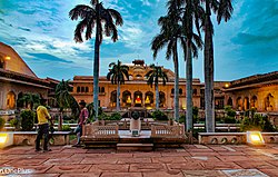
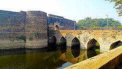
Bharatpur is a city in the Indian state of Rajasthan, 189 km (117 mi) south of India's capital, New Delhi, 184 km (114 mi) from Rajasthan's capital Jaipur, 56 km (35 mi) west of Agra of Uttar Pradesh and 36 km (22 mi) from Mathura of Uttar Pradesh. It is the administrative headquarters of Bharatpur District and the headquarters of Bharatpur Division of Rajasthan State. Bharatpur is part of National Capital Region of India. [2] The city was the capital of the Bharatpur State. It became a municipal corporation with 65 wards in 2014. [3] [4] [5] [6]
Ancient Period
Bharatpur was a part of the Matsya Kingdom, one of the sixteen ancient Mahājanapadas.
| Climate data for Bharatpur (1991–2020) | |||||||||||||
|---|---|---|---|---|---|---|---|---|---|---|---|---|---|
| Month | Jan | Feb | Mar | Apr | May | Jun | Jul | Aug | Sep | Oct | Nov | Dec | Year |
| Record high °C (°F) | 29.5 (85.1) | 35.6 (96.1) | 41.9 (107.4) | 47.0 (116.6) | 48.5 (119.3) | 47.8 (118.0) | 46.7 (116.1) | 40.9 (105.6) | 41.2 (106.2) | 40.5 (104.9) | 39.6 (103.3) | 30.7 (87.3) | 48.5 (119.3) |
| Mean daily maximum °C (°F) | 20.7 (69.3) | 26.5 (79.7) | 32.2 (90.0) | 39.9 (103.8) | 42.5 (108.5) | 40.5 (104.9) | 36.9 (98.4) | 34.6 (94.3) | 35.1 (95.2) | 34.7 (94.5) | 30.1 (86.2) | 23.4 (74.1) | 32.3 (90.1) |
| Mean daily minimum °C (°F) | 8.1 (46.6) | 12.0 (53.6) | 16.0 (60.8) | 22.8 (73.0) | 27.4 (81.3) | 28.2 (82.8) | 27.9 (82.2) | 26.4 (79.5) | 25.4 (77.7) | 20.6 (69.1) | 14.4 (57.9) | 8.8 (47.8) | 19.1 (66.4) |
| Record low °C (°F) | 1.9 (35.4) | 1.7 (35.1) | 6.8 (44.2) | 11.4 (52.5) | 17.8 (64.0) | 18.0 (64.4) | 19.2 (66.6) | 22.2 (72.0) | 19.0 (66.2) | 12.2 (54.0) | 5.2 (41.4) | 2.8 (37.0) | 1.7 (35.1) |
| Average rainfall mm (inches) | 8.2 (0.32) | 9.5 (0.37) | 4.0 (0.16) | 7.0 (0.28) | 10.4 (0.41) | 77.4 (3.05) | 170.3 (6.70) | 213.0 (8.39) | 140.2 (5.52) | 18.1 (0.71) | 4.7 (0.19) | 4.3 (0.17) | 667.1 (26.26) |
| Average rainy days | 0.8 | 0.6 | 0.7 | 0.7 | 1.2 | 3.6 | 9.2 | 9.8 | 5.8 | 0.9 | 0.6 | 0.5 | 34.4 |
| Average relative humidity (%) (at 17:30 IST) | 62 | 49 | 40 | 33 | 30 | 42 | 65 | 68 | 64 | 49 | 54 | 63 | 52 |
| Source: India Meteorological Department [7] | |||||||||||||
| Year | Pop. | ±% |
|---|---|---|
| 1891 | 43,000 | — |
| 1911 | 44,000 | +2.3% |
| 1941 | 35,500 | −19.3% |
| 1951 | 37,300 | +5.1% |
| 1961 | 49,800 | +33.5% |
| 1971 | 69,400 | +39.4% |
| 1981 | 105,200 | +51.6% |
| 1991 | 156,900 | +49.1% |
| 2001 | 205,235 | +30.8% |
| 2011 | 252,883 | +23.2% |
| Source: [8] [9] | ||
As of 2011 [update] Indian census, Bharatpur has a population of 252,838. [11]
At the time of the 2011 census, 71.61% of the population recorded their language as Hindi, 26.25% Braj Bhasha and 1.08% Punjabi as their first language. [12]