
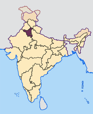
Rajasthan is a state in northern India. It covers 342,239 square kilometres (132,139 sq mi) or 10.4 per cent of India's total geographical area. It is the largest Indian state by area and the seventh largest by population. It is on India's northwestern side, where it comprises most of the wide and inhospitable Thar Desert and shares a border with the Pakistani provinces of Punjab to the northwest and Sindh to the west, along the Sutlej-Indus River valley. It is bordered by five other Indian states: Punjab to the north; Haryana and Uttar Pradesh to the northeast; Madhya Pradesh to the southeast; and Gujarat to the southwest. Its geographical location is 23°.3' to 30°.12' North latitude and 69°.30' to 78°.17' East longitude, with the Tropic of Cancer passing through its southernmost tip.
The Other Backward Class (OBC) is a collective term used by the Government of India to classify castes which are educationally or socially backward. It is one of several official classifications of the population of India, along with general castes, Scheduled Castes and Scheduled Tribes (SCs and STs). The OBCs were found to comprise 52% of the country's population by the Mandal Commission report of 1980, and were determined to be 41% in 2006 when the National Sample Survey Organisation took place. There is substantial debate over the exact number of OBCs in India; it is generally estimated to be sizable, but many believe that it is higher than the figures quoted by either the Mandal Commission or the National Sample Survey.

Mewat is a historical region of Haryana and Rajasthan states in northwestern India. The loose boundaries of Mewat generally include Hathin tehsil and Nuh district of Haryana, Alwar, Mahwa, Rajasthan and Mandawar, Rajasthan in Dausa district and Bharatpur districts of Rajasthan, and Chhata Tehsil of Mathura district in Uttar Pradesh. The main centre areas of Mewat are Firozpur Jhirka, Nuh, Ramgarh, Paharisikri and Punahana. Mewat region lies in between Delhi-Jaipur-Agra. In simple words Mewat region consists of Nuh district, eastern part of Alwar district and western part of Bharatpur district. Mandawar, Rajasthan and Mahwa, Rajasthan is in Dausa district but there are many Meos villages near Mahwa, Mandawar, Garhi sawairam, Pinan. The region roughly corresponds to the ancient kingdom of Matsya, founded in the 5th century BCE. Mewati dialect, a slight variant of the Haryanvi and Rajasthani dialects of Hindi, is spoken in rural areas of the region. Mewati Gharana is a distinctive style of Indian classical music.

Alwar is a district in the state of Rajasthan in northern India, whose district headquarters is Alwar city. The district covers 8,380 km2. It is bound on the north by Rewari district of Haryana, on the east by Bharatpur district of Rajasthan and Nuh district of Haryana, on the south by Dausa district, and on the west by Jaipur district.
Kherli is a city and a municipality in Alwar district in the Indian state of Rajasthan.Kherli mandi(Grain Market) is the second largest mandi in Rajasthan. Once upon a time it was so much famous that till now old jaipur people knows this as ganj kherli i.e. kherli mandi. Kherli is between the golden triangle where it is nearest to Agra(125 km) Jaipur(150 km) and Delhi(175 km).This area also comes under NCR but still they are not getting benefit of close proximity to these 3 big cities.
Khinwasar or Khiwasar (खींवासर) is a village in Sikar district of Indian state of Rajasthan. It is located at a distance of 15 km east of Laxmangarh which is village's Tehsil too. It was founded about 200 years back. Village has got some signs of old habitations.
Kari is a village in Jhunjhunu district of Rajasthan state in India. It is situated 17 km west of Nawalgarh and is connected to nearby cities such as Jhunjhunu and Gudha by roads. It is a 4000 -year-old village. Pareek's are said to be the first inhabitants of the village.
Kanwari, also spelled Kunwari, or Kwari, is a village of 7,000 population, in Hansi-I Tehsil, Hisar-1 Rural Development Block, Hansi and Hisar of Hisar District of Hisar Division in the Haryana state of India. It is part of the saat bas bhaichara grouping of 7 villages. The village has 4 panna/patti (subdivisions), named as Nangalia Panna , upparla Panna , parla Panna , etc. with a total revenue land area of 43903 kanal or 5487 acre as per HALRIS records.
Rajiasar Meetha is a cluster of three villages located in the Churu district of Rajasthan.
Chadiwal is a village in Sirsa District of Haryana State, India. It is said to have been settled in 1896 AD by a Muslim named Chadi Khan. But there is evidence of its settlement before 1896 AD in Bai-Bhat of Beniwal gotra. In this village mainly residents of Beniwal, Godara, Saharan, Bhattu and Birda gotra of Jat caste are more. People of Brahmin, Harijan and Valmiki caste also reside in the village.

Dhani or Thok is a type of hamlet, the smallest conglomeration of houses, in sandy Bagar region of northwestern states of Rajasthan, Haryana and Punjab in India. Per Census of India, 70% of Indians live in villages. 80% of the villages have a population of less than 1000 people and each consists of a cluster of hamlets. Most dhanis are nucleated settlements, while others are more dispersed. A dhani could be as small as one isolated house for a single family or a small cluster of several houses which could grow in number with successive generations, and even become a village by itself. All families living in a dhani are relatives or at least are of the same caste. An isolated collection of several of dhanis, which could be few hundred meters apart, constitutes a gram panchayat village community. A typical dhani in the arid zone of Rajasthan is a cluster of huts with a boundary made of dried shrubs around it and with owners' livestock such as goats, sheep and camels inside the bara. Dhani are atypically mud huts in Rajasthan. Houses in dani nowadays are made of modern brick and mortar, specially in affluent higher-per-capita-income states of Haryana and Punjab, and some richer families of Rajasthan.
Rajasthani people or Rajasthanis are a group of Indo-Aryan peoples native to Rajasthan, a state in Northern India. Their language, Rajasthani, is a part of the western group of Indo-Aryan languages.

Newara is a village and a panchayat in the weir tehsil of the Bharatpur district in the state of Rajasthan, India. It is situated south-west of Bharatpur at a distance of about 37 km. Newara is situated 5 km away from the NH-11 road, between Jaipur and Agra.

Sunari is a village in Ladnun tehsil, Nagaur district, Rajasthan, north west India. Its lok sabha is Churu constituency. The residents, numbering between five and six thousand, are Hindu. Sunari lies on the edge of the Thar desert.
Bhoodha Ka Bas is a village in the Laxmangarh administrative region of the Sikar district of Indian state Rajasthan. Bhoodha Ka Bas village is separated from the Beerodi Bari village and situated in the north-east side of the Sikar district. Village is situated approximately 22 kilometres (14 mi) east of Laxmangarh town and 4 kilometres (2.5 mi) west of Nawalgarh town.
Birodi Bari or Birodi Badi or Bidodi Badi or Beerodi Bari is a village in the Laxmangarh administrative region of Sikar district of Indian state Rajasthan. It lies 20 kilometres (12 mi) east of Laxmangarh and 3.5 kilometres (2.2 mi) west of Nawalgarh. It borders Khinwasar, Bidsar, Bidasar, Birodi Chhoti, Jhadhewa, Jogiyon ka bas, Ramsingh Pura and Bhoodha Ka Bas villages.
Bidasar or Beedasar is a village in the Laxmangarh administrative region of Sikar district of Indian state Rajasthan. It lies 15 kilometres (9.3 mi) east of Laxmangarh and 7 kilometres (4.3 mi) west of Nawalgarh. It borders Khinwasar, Birodi Bari, Bidsar, Birodi Chhoti, Jogiyon ka bas, and Brahmino ki Dhani villages.
Rajendra Choudhary is a politician in Rajasthan, Haryana, Delhi and other Jat dominating state in North India. Choudhary has served as Member of the Rajasthan Legislative Assembly and has held several state government portfolios and different ministries:
Kalali is a village and administrative unit with a democratically elected panchayat samiti in the Loharu, Siwani Tehsil of Bhiwani District under Bhiwani-Mahendragarh Lok Sabha constituency and Hisar Division of Haryana state.
Nathi Singh is an Indian politician. He is known to be a prominent farmer Leader from Bharatpur district, in Rajasthan. He was a Cabinet Minister in Rajasthan and held the portfolio of Revenue and Forest from 4 March 1990 to 15 November 1990, when he was the leader of the Janta Dal MLAs, in the coalition government of BJP and Janta Dal in Rajasthan. He was a Member of Parliament of the Rajya Sabha from April 1974 to April 1980 and a Member of the Rajasthan Legislative Assembly for four terms from 1962 to 1972, from Bharatpur and from 1985 to 1995, from Deeg-Kumher constituency, both in the Bharatpur district of eastern Rajasthan. He was associated with the Indian National Congress, Previously he was associated with Janta Dal.

