Anupgarh district

Last updated

Anupgarh district
View of canal during sunset in Rawla.jpg
View of canal in tehsil Rawla Mandi of Anupgarh district
Anupgarh in Rajasthan (India).svg
Location of Anupgarh district in Rajasthan
Coordinates(Anupgarh district headquarters): 29°11′22″N73°12′30″E / 29.18944°N 73.20833°E / 29.18944; 73.20833
CountryFlag of India.svg  India
State Rajasthan
Division Bikaner
Established7 August 2023
Headquarters Anupgarh
Tehsils Raisinghnagar
Anupgarh
Sri Vijaynagar
Gharsana
Rawla Mandi
Government
  TypeState Government
  BodyGovernment of Rajasthan
   District Magistrate Avdhesh Meena, IAS [1]
  Superintendent of PoliceRajendra Kumar, IPS
Area
  Total4,713.96 km2 (1,820.07 sq mi)
Population
 (2011) [2]
  Total698,478
  Density150/km2 (380/sq mi)
Demographics [2]
   Literacy 58.18 %
   Sex ratio 899/1000
Languages
  Official Hindi [3]
  Additional_official English [3]
  Most spoken Punjabi, Bagri, Rajasthani
Time zone UTC+05:30 (IST)
Major highways RJ SH 3
Website official website

Anupgarh district is a new north-west district of Rajasthan state in India. It was established on 7 August 2023 after curving it out of Sri Ganganagar District.

Contents

History

Ancient history

Traces of Indus Valley Civilisation have been found at Baror and Binjor near Anupgarh city.

Mediaeval period

Medieval fort of Anupgarh Anupgarh fort.jpg
Medieval fort of Anupgarh

The ancient name of Anupgarh city was Chugher. Chugher (Anupgarh) and its surrounding area was occupied by Bhati rulers. The area was occupied by the removal of Bhati Chiefs by Maharaja of the Bikaner princely state under the leadership of chief Bikaji Anoop Singh in 1678 and constructed a fortress whose name was Anupgarh. [4]

Post-partition and modern history

After partition of India in 1947, Princely states were abolished and Anupgarh being a Dyodhiwale Rajvi, was made a separate tehsil under Sri Ganganagar District.

On 17 March 2023, [5] following 11 years of peaceful protest by the local citizens under the leadership of Advocate Suresh Kumar Bishnoi, Jalandhar singh Toor with the support of farmers and other respectful leaders, it was carved out of Sri Ganganagar as a separate district.

Demographics

Population

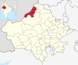
According to 2011 census of India, the total population of what is now Anupgarh district was 698,478. 114919 (16.45%) lived in urban areas. Anupgarh district had a sex ratio of Scheduled Castes and Scheduled Tribes made up 307,944 (44.09%) and 3,760 (0.60%) of the population respectively. [7] [8]

Total population, total families and Population density of tehsils according to 2011 census. [9] [10] [11] [12]
TehsilPopulationTotal familiesPopulation Density people/km2
Raisinghnagar196,45537,854148/km2
Anupgarh1,84,42336,488159/km2
Gharsana (including Rawla Mandi)1,71,83034,350124/km2
Sri Vijaynagar1,45,77028,721172/km2
Total/Average of Anupgarh District6,98,4781,37,413150.75/km2

Languages

Languages of Anupgarh district (2011 census) [5]

   Punjabi (32.80%)
   Bagri (29.04%)
   Rajasthani (28.00%)
   Hindi (4.99%)
   Marwari (2.55%)
  Others (2.62%)

At the time of the 2011 census, 32.80% Punjabi, 29.04% Bagri, 28.00% Rajasthani, 4.99% Hindi and 2.55% Marwari as their first language. [13] Along the India-Pakistan border, the language merges with the Riasti dialect of Saraiki.

Religion

Religious profile of tehsils according to 2011 census.
TehsilHinduSikhMuslimJainBuddhistChristiansNot statedOthers
Raisinghnagar [9] 1,35,96558,8571,1181581101614838
Anupgarh [10] 1,25,62456,1192,394634145947
Gharsana (including Rawla Mandi) [11] 1,22,44040,4128,62013051965229
Sri Vijaynagar [12] 1,11,08932,4681,70020156268672
Total of Anupgarh District4,95,1181,87,85613,83231446355826176
Religions in Anupgarh District (2011)
ReligionPercent
Hinduism
70.89%
Sikhism
26.90%
Islam
1.98%
Other or not stated
0.23%

Census 2011 shows that there were 4,95,118 Hindus and 1,87,856 Sikhs in the district with Muslims being third largest community in the district with around 13,832 individuals. [14]

Literacy rate

Average literacy rate and Sex ratio in Anupgarh district is 64.25 % and 898.5/1000 respectively.

According to census 2011, with 69.91% literacy, and a ratio of 908 females to 1000 males. Raisinghnagar is the most literate tehsil in Anupgarh district with hights sex ratio with 69.33% of male literates and 52.23% of female literates living in the tehsil. On the other hand, Gharsana shows the lowest literacy rate of 65.76% with 65.54% of males and 47.28% of females literate in the tehsil. Gharsana tehsil had a sex ratio of 892 females/1000 males in year 2011 which was least among all tehsils of Anupgarh District and Raisinghnagar had hightest sex ratio of 902 females/1000 males.

Total literally rate and sex ratio among tehsils and Anupgarh district according to 2011 census.
TehsilTotal literacy rateMale literacyFemale literacySex Ratio females/1000 males
Raisinghnagar [9] 69.91%69.33%52.23%908
Anupgarh [10] 66.34%65.39%48.57%900
Gharsana (including Rawla Mandi) [11] 65.76%65.54%47.28%892
Sri Vijaynagar [12] 66.68%64.55%48.98894
Literacy rate and Sex ratio in district64.25 %63.45 %45.72 %899

Government and politics

Assembly constituencies

5. Raisinghnagar Assembly constituency

6. Anupgarh Assembly constituency

Administrative setup of Anupgarh District

District map of Anupgarh District map of Anupgarh.jpg
District map of Anupgarh

Tehsil in Anupgarh District

There are 5 tehsils in the Anupgarh district.

  1. Anoopgarh
  2. Shri Vijaynagar
  3. Gharsana
  4. Rawla Mandi
  5. Raisinghnagar

Sub tehsils in Anupgarh District

In Anupgarh District There are also 5 Sub tehsils-

  1. Sameja
  2. Muklawa
  3. Jaitsar
  4. Ramsinghpur
  5. 365 Head.

Panchayat Samitis in Anupgarh District

There are six Panchayat Samitis or Block panchayats and 177 Gram Panchayats in Anupgarh district.

  1. Anupgarh - 32 Gram Panchayats
  2. Raisinghnagar - 41 Gram Panchayats
  3. Vijaynagar - 29 Gram Panchayats
  4. Gharsana - 36 Gram Panchayats.

Tourist attractions

The graves of Layla and Majnun, where people come to seek blessings Laila majnun mazar(Mausoleum),Anupgarh Sivender.jpg
The graves of Layla and Majnun, where people come to seek blessings
  1. Shivpur Fort - Vijaynagar
  2. Anupgarh Fort - Anupgarh
  3. Baror Harrapan Archaeological site -Anupgarh
  4. Gurudwara Budhdha Johar - Dabla
  5. Bishnoi Mandir & Amrita Devi Park - Dabla
  6. Laila Majhnu Mazar - Binjor
  7. Central Farm Jaitsar
  8. Rojhari Bala ji temple

Gallary

Related Research Articles

<span class="mw-page-title-main">Hanumangarh</span> City in Rajasthan, India

Hanumangarh is a city and municipal council in the Indian state of Rajasthan, situated on the banks of the river Ghaggar also identified as ancient Sarasvati river, located about 400 km from Delhi. It is the administrative headquarter of Hanumangarh District. The city was once called Bhatner because it was founded by king Bhupat in 255 AD. It remained in the control of the Rajputs of Bhati clan and faced a historic siege by Timur in 1391, during which the Bhati Raput king Dulachand lost the fort for a short time. The fort was later occupied by Rao Jetsa of Bikaner.

<span class="mw-page-title-main">Sri Ganganagar</span> City in Rajasthan, India

Sri Ganganagar is the northernmost city of the Indian state of Rajasthan, near the international border of India and Pakistan. It is the administrative headquarters of Sri Ganganagar district. It is named after Maharaja Shri Ganga Singh Bahadur, Maharaja of Bikaner. The city is also known as the "Food Basket of Rajasthan".

<span class="mw-page-title-main">Bikaner district</span> District of Rajasthan in India

Bikaner District is a district of the state of Rajasthan in western India. The historic city of Bikaner is the district headquarters. The district is located in Bikaner Division along with the three other districts of Anupgarh, Sri Ganganagar and Hanumangarh.

<span class="mw-page-title-main">Jodhpur district</span> District of Rajasthan in India

Jodhpur District is a district in the State of Rajasthan in western India. The city of Jodhpur is the administrative headquarters of the district.

<span class="mw-page-title-main">Hanumangarh district</span> District in Rajasthan, India

Hanumangarh district is a district in the state of Rajasthan in India. The city of Hanumangarh is the district headquarters and its largest city.

<span class="mw-page-title-main">Sri Ganganagar district</span> District of Rajasthan in India

Sri Ganganagar district is the northernmost district of Rajasthan state of India.

<span class="mw-page-title-main">Anupgarh</span> Town in Rajasthan, India

Anupgarh is a town in the state of Rajasthan in India. It is administrative headquarters of the Anupgarh district, which was formed on 17 March 2023.

Raisinghnagar is a town and a municipality (Tehsil) in Anupgarh district in the Indian state of Rajasthan. The town is surrounded by fertile land.

Vijaynagar or Vijaynagar is a town and a municipality in Anupgarh district in the Indian state of Rajasthan.

<span class="mw-page-title-main">Rawla Mandi</span> Town in Rajasthan, India

Rawla Mandi is a town in Rawla Mandi tehsil of Anupgarh district of Rajasthan, India. It is located on Gharsana-Khajuwala road,50 kms from district headquarter Anupgarh and 27 km away from Gharsana and 180 km from the Sri Ganganagar. The state capital Jaipur is 480 km away, and national capital New Delhi is 500 km away. It is 33 km from Khajuwala and 122 km from Bikaner. It is 30 km far from Indo-Pak(India-Pakistan) border. Rawla mandi known as 8PSD (B) gram panchayt. Rawla Gaon Also located in West of rawla mandi

<span class="mw-page-title-main">4 KLM</span> Village in Rajasthan, India

4 KLM is a small village in Rawla Mandi tehsil of Sri Ganganagar district, Rajasthan, India. It is 186 km from district headquarters. It borders on the Bikaner district to the south. Kumhars of Hathusar village are original residents of this village. The major occupations include farming, labour and mining.

Karanpur tehsil is one of the nine tehsils of Sri Ganganagar district, Rajasthan. It falls in the north-west of the district. Karanpur city is the headquarters of the tehsil. Its north-west border touches Bahawalnagar district of Pakistani Punjab. It is bordered in the east by Shriganganagar tehsil and Padampur tehsil, and in the south by Raisinghnagar tehsil.

<span class="mw-page-title-main">Vijaynagar tehsil</span>

Sri Vijaynagar Tehsil is the one of five tehsils of Anupgarh district of Rajasthan, India. It is located in the Eastern part of District Anupgarh. It is bordered by Anoopgarh tehsil in the west, by Raisinghnagar tehsil in the north, Suratgarh tehsil in the east, and Bikaner district in the south.

<span class="mw-page-title-main">Fort Abbas Tehsil</span> Tehsil in Punjab, Pakistan

Fort Abbas is a tehsil located in Bahawalnagar District, Punjab, Pakistan.

Raisinghnagar Tehsil is a tehsil of Anupgarh district, Rajasthan, India. It is in the central-western area of the district. Raisinghnagar is the headquarters of the tehsil. Sameja and Muklawa are Sub Tehsil in Raisinghnagar

365 Head, also called 2 KLD is a village in Anupgarh district of Rajasthan, India. It is located in the south-western region of Gharsana Tehsil, 74 kilometers from Anupgarh district headquarter and 198.2 kilometers from Ganganagar. 365 Head has gram panchayat status. It is named after the 365 R.D. of Anoopgarh branch canal.

<span class="mw-page-title-main">Anupgarh Tehsil</span> Tehsil in Rajasthan, India

Anupgarh Tehsil is the one of Seven tehsils of Anupgarh district in Rajasthan, India. The tehsil headquarters are located at the town of Anupgarh.

<span class="mw-page-title-main">Rojhri dham</span> Hindu temple in Rajasthan, India

Rojhri Dham is a complex of religious sites dedicated to the worship of the Hindu deity Hanuman. It is situated in Rawla Mandi tehsil of Anupgarh district of Rajasthan.

Jaitsar is a town in the Anupgarh district district of Rajasthan,

<span class="mw-page-title-main">Rawla Mandi tehsil</span> Tehsil in Rajasthan, India

Rawla Mandi Tehsil is one of the 5 tehsils from the Anupgarh district in Rajasthan, India. It was carved out of Gharsana tehsil and given the status of tehsil by CM Vasundhara Raje in 2017. Its northern border connects it with Gharsana tehsil of Anupgarh district and Chhatargarh and Khajuwala tehsil of Bikaner district are in the south. Its western border is connected with Fort Abbas Tehsil that is the Bahawalnagar district of Pakistani Punjab.

References

  1. "Anupgarh - District Administration". Government of Rajathan. Retrieved 25 February 2024.
  2. 1 2 https://www.censusindia2011.com/rajasthan/ganganagar-population.html
  3. 1 2 "Report of the Commissioner for linguistic minorities: 52nd report (July 2014 to June 2015)" (PDF). Commissioner for Linguistic Minorities, Ministry of Minority Affairs, Government of India. pp. 34–35. Archived from the original (PDF) on 28 December 2017. Retrieved 16 February 2016.
  4. Singh, Rajvi Amar (1992). Mediaeval History of Rajasthan: Western Rajasthan. Bikaner, Rajasthan, India: Singh. p. 347. OCLC   29798320.
  5. 1 2 "Rajasthan CM Ashok Gehlot announces formation of 19 new districts, 3 Divisional headquarters in Rajasthan". AIR News. 17 March 2023. Retrieved 11 June 2023.
  6. name="languages2"> "खाजूवाला और छतरगढ़ तहसील को अनूपगढ़ से हटाया". Dainik Bhaskar. 6 October 2023. Retrieved 6 October 2023.
  7. "District Census Handbook: Sri Ganganagar" (PDF). censusindia.gov.in. Registrar General and Census Commissioner of India. 2011.
  8. "District Census Handbook 2011 - Bikaner" (PDF). Census of India . Registrar General and Census Commissioner of India.
  9. 1 2 3 https://www.censusindia2011.com/rajasthan/ganganagar/raisinghnagar-population.html
  10. 1 2 3 https://www.censusindia2011.com/rajasthan/ganganagar/anupgarh-population.html
  11. 1 2 3 https://www.censusindia2011.com/rajasthan/ganganagar/gharsana-population.html
  12. 1 2 3 https://www.censusindia2011.com/rajasthan/ganganagar/vijainagar-population.html
  13. "Table C-16 Population by Mother Tongue: Rajasthan". www.censusindia.gov.in. Registrar General and Census Commissioner of India.
  14. "Table C-01 Population by religious community: Rajasthan". censusindia.gov.in. Registrar General and Census Commissioner of India.