
Udaipur district is one of the 33 districts of Rajasthan state in western India. The historic city of Udaipur is the administrative headquarters of the district. The district is part of the Mewar region of Rajasthan.
Bhilwara District is a district of the state of Rajasthan in western India. The town of Bhilwara is the district headquarters.

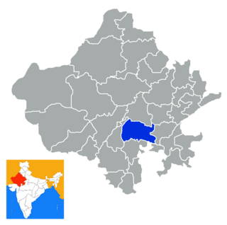
Dausa District is a district of Rajasthan state in India within Jaipur division. The city of Dausa is the district headquarters. It has an area of 3432 km² and a population of 1,634,409 in 2011 census. It is surrounded by Alwar District in the north, Bharatpur District in the northeast, Karauli District in the southeast, Sawai Madhopur District in the south, and Jaipur District in the west. Dausa district is divided into eight tehsils - Baswa, Dausa, Lalsot, Mahwa, Sikrai, Lawan, Nangal Rajawatan and Ramgarh Panchwara. The Sawa and Ban Ganga rivers run through the district. It is situated on the National Highway 11 from Jaipur to Agra. It is 55 km to the east of Jaipur and 103 km from Sawai Madhopur.

Sirohi District is a district of Rajasthan state in western India. The town of Sirohi is the district headquarters.

Dhariawad is a census town in Pratapgarh district (Rajasthan) in the state of Rajasthan, India. It is the administrative headquarters for Dhariawad Tehsil.
Kapasan is a city and a municipality in Chittaurgarh district in the Indian state of Rajasthan.
Bhinder or Bhindar is a town in Udaipur District, that is located 315 km (196 mi) from the state's main city Jaipur. Bhinder borders the Chittorgarh District in Rajasthan and is located 58 kilometres (36 mi) south-east of Udaipur. Notable tourist sites nearby include Sita Mata Wildlife Sanctuary, Jaisamand Sanctuary, and Jaisamand Lake. Bhinder is surrounded by four lakes.
Kheri Shilla is a village in Makrana tehsil in Nagaur district, Rajasthan state of India. It is 7 km from Gachhipura. Other names for Kheri Shella are Mundelo Ki kheri and Guda Kheri, and the latest name of is Devnagari Kheri Sheela.
Boraj Tawaran is a village in the Udaipur district of Rajasthan, India. It comes under the Malpur gram panchayat, in Salumber block. The village is located 8 km east of Salumber. It is also known as Boraj Tanwaran or Boraj Tavraan. Salumbar is nearest town to Boraj Tawaran village. Around 1700 CE, a Thakur of the Tanwar clan moved to Salumber during the rule of Rawat Kesari Singh Chundawat. In 1876, his descendant Thakur Tej Singh Tanwar was granted the jagir of the present-day village site to Rawat Jodh Singh Chundawat.

Kotra is a tehsil of Udaipur district in Rajasthan, India, consisting of 262 revenue villages and 31 panchayats. The tehsil is bordered to the north by Pali and Sirohi districts, to the east by Gogunda and Jhadol tehsils, and to the south by Gujarat state. The tehsil headquarter is located in the village of Kotra, southwest of the Udaipur at a distance of 57 km and 120 km by road.
Bedla is a census town in the Bargaon tehsil of Udaipur district, Rajasthan, India. It is situated near Sukher area, on the Udaipur-Nathdwara highway, around 8km from the city center and around 387km from state capital Jaipur. Nearby Bedla, there is Udaipur Tehsil towards South, Gogunda Tehsil towards west, Khamnor Tehsil towards North and Mavli Tehsil towards East.
Bargaon is a census town in the Girwa tehsil of Udaipur district, Rajasthan, India. It is situated on the Udaipur-Gogunda highway, around 4 kilometres (2.5 mi) from the city centre, 2 kilometres (1.2 mi) from Bhuwana and around 387 kilometres (240 mi) from the state capital at Jaipur. It has Dungla Tehsil towards East, Bhopalsagar Tehsil towards North, Mavli Tehsil towards North and Bhadesar Tehsil towards East.
Dhanuri is a village in Malsisar Tehsil in Jhunjhunu District of Rajasthan State, India. Dhanuri village is located in Jhunjhunun Tehsil of Jhunjhunun district in Rajasthan, India. It is situated 15km away from Jhunjhunun, which is both district & sub-district headquarter of Dhanuri village. As per 2009 stats, Dhanuri village is also a gram panchayat. By: Ayaj Khan.

Jhadol tehsil is an administrative sub-division of Udaipur district in Rajasthan, India. Jhadol tehsil was formerly called Phalasia tehsil. The tehsil consists of 283 revenue villages and 45 panchayats. The tehsil headquarter is located in the village of Jhadol, southwest of the district headquarters, Udaipur.

Gogunda is a tehsil of Udaipur district in Rajasthan, India. The tehsil consists of 232 revenue villages, 45 panchayats, and 1 census town. The tehsil headquarter is located in the town of Gogunda.
Biliya is a village in Udaipur district in the Indian state of Rajasthan. The District head quarter of the village is Udaipur. It is 13 kilometers away from the Udaipur district headquarters. As per Population Census 2011, the total population of Biliya is 350. Males constitute 49% of the population and females 51%. The literacy rate of Biliya village is 60.0% as per 2011 census.
Cheetarawas is a village in Gogunda Tehsil in Udaipur district in the Indian state of Rajasthan. It is located 70 km away from district headquarter Udaipur. As per Population Census 2011, Cheetarawas village has population of 845.
Jeerai is a village in Gogunda Tehsil in Udaipur district in the Indian state of Rajasthan. The District headquarter of the village is Udaipur.
Majam is a village in Gogunda Tehsil in Udaipur district in the Indian state of Rajasthan. The District headquarter of the village is Udaipur.
Tarpal is a small Village in Gogunda Tehsil in Udaipur District of Rajasthan, situated about 413 km from Jaipur and around 53 km from the District headquarter Udaipur.

