
Rajasthan is a state in northwestern India. It covers 342,239 square kilometres (132,139 sq mi) or 10.4 per cent of India's total geographical area. It is the largest Indian state by area and the seventh largest by population. It is on India's northwestern side, where it comprises most of the wide and inhospitable Thar Desert and shares a border with the Pakistani provinces of Punjab to the northwest and Sindh to the west, along the Sutlej-Indus River valley. It is bordered by five other Indian states: Punjab to the north; Haryana and Uttar Pradesh to the northeast; Madhya Pradesh to the southeast; and Gujarat to the southwest. Its geographical location is 23°.3' to 30°.12' North latitude and 69°.30' to 78°.17' East longitude, with the Tropic of Cancer passing through its southernmost tip.
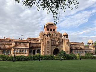
Bikaner is a city in the northwest of the state of Rajasthan, India. It is located 330 kilometres (205 mi) northwest of the state capital, Jaipur. Bikaner city is the administrative headquarters of Bikaner District and Bikaner division.

The North Western Railway is one of 19 railway zones in India. It is headquartered at Jaipur, Rajasthan and has 59,075+ employees, 658+ stations and a route length of more than 5,761 kilometres (3,580 mi) across the states of Rajasthan, Gujarat, Punjab and Haryana. NWR operates international rail service Thar Express from Jodhpur to Karachi. This zone is the key enabler of the Delhi–Mumbai Industrial Corridor Project by virtue of running railways 1,500 km long Western Dedicated Freight Corridor.
Ratangarh is a town and Tehsil of the Churu district in Rajasthan, India. Ratangarh was previously called Kolasar. It is famous for grand havelis (mansions) with frescoes, which is an architectural specialty of the Shekhawati region. Ratangarh is also famous for its handicraft work.

Sri Ganganagar is the northernmost city of the Indian state of Rajasthan, near the international border of India and Pakistan. It is the administrative headquarters of Sri Ganganagar district. It is named after Maharaja Shri Ganga Singh Bahadur, Maharaja of Bikaner. The city is also known as the "Food Basket of Rajasthan".
Sadulpur ,(previously known as Rajgarh) is a city, municipality, tehsil and Legislative Assembly seat in Churu district of northern part of Rajasthan state in India. It was the territory of the gaur dynasty later after defeated in war with shekhawat rajputs ,It lies in Shekhawati region at an elevation of 239 m (784 ft). To distinguish Rajgarh from several other places with same name, Sadulpur has become a synonym of Rajgarh town's name in recent times.

Bikaner District is a district of the state of Rajasthan in western India. The historic city of Bikaner is the district headquarters. The district is located in Bikaner Division along with the three other districts of Anupgarh, Sri Ganganagar and Hanumangarh.

Balotra is a city situated in the Balotra district within the state of Rajasthan, India. Previously, it was located in the Barmer district of the Indian state of Rajasthan. It is known for its historical and cultural significance, as well as its role as a commercial and trading center in the region.
Chhapar is a small town and a municipality in Churu district in the state of Rajasthan, India. Chhapar and Tal chhapar is located in the Churu district of Northwestern Rajasthan in the Shekhawati region of India. It is 210 km from Jaipur and situated on the road from Ratangarh to Sujangarh. The Tal Chappar lies in the Sujangarh Tehsil of Churu district. It lies on the Nokha-Sujangarh state highway and is situated at a distance of 85 km from Churu and about 132 km from Bikaner. The nearest railway station is Chappar which lies on Degana-Churu-Rewari broad gauge line of Northern Western Railways. The nearest Airport is Jaipur International Airport (Sanganer) which is at a distance of 215 km from Chappar. It is known for black bucks but it is also home to a variety of birds. Here is a famous sanctuary known as Tal Chhapar Sanctuary
Phalodi is a city in Phalodi district in the Indian state of Rajasthan. It is the headquarters for Phalodi district. Phalodi is also called the "salt city" due to the salt industry in Rin. Phalodi is in the buffer zone of Thar Desert and often subject to extreme temperature conditions due to its arid climate. The highest temperature in the history of Phalodi is 51°C, which is the highest ever verified temperature in the country.
Pilibanga is a town and a municipality in Hanumangarh district in the Indian state of Rajasthan.
Kheri Leela is a small village in Makrana tehsil, Nagaur district, Rajasthan, India.
Devli Kalan is a village in Nawa Tehsil in Didwana Kuchaman district of Rajasthan State, India. It belongs to Ajmer Division. It is located 176 km towards East from District headquarters Nagaur, 60 km from State capital Jaipur. Devli Kalan Pin code is 341507 and postal head office is Maroth. Renwal, Jaipur, Sambhar, Phulera, Reengus are the nearby Cities to Devli Kalan. Minda, Loonwa, Shyamgarh & KANCHANPURA 1.5 km are the nearby Villages to Devli Kalan. As per constitution of India and Panchyati Raaj Act, Devli Kalan village is administrated by Sarpanch who is elected representative of village.
Jasrasar is a tehsil located in Bikaner district of Rajasthan state, India. It is located 280 kilometres (174 mi) from Jaipur, 225 kilometres (140 mi) from Jodhpur and 483 kilometres (300 mi) from Mount Abu.
Dulchasar is a village located in Sridungargarh sub district, Bikaner district of Rajasthan state, India. It is located 299 kilometres (186 mi) from Jaipur, 266 kilometres (165 mi) from Jodhpur and 524 kilometres (326 mi) from Mount Abu.
Jhajhoo Village is a large rural village located in Kolayat Tehsil of Bikaner of Rajasthan state, India.
Mandukara or Mandukra is a village located in Didwana tehsil in Nagaur of Rajasthan state, India.
Manyana is a village located in Nokha tehsil of Bikaner district of Rajasthan state, India.

Malasar(हिंदी: मालासर) is a large village located in Bikaner District which is in the north-west of the state of Rajasthan, India. This village is the Panchayat headquarters of three nearby villages. There are a total of 450 houses in the village. This village is popular for its unique geographical location, beautiful sand dunes and sandy paths located in the heart of the Thar Desert.
Dandusar is a village located in Bikaner Tehsil of Bikaner District of Rajasthan state, India and only 3 km from Malasar village of Bikaner District.

