
Rajasthan is a state in northwestern India. It covers 342,239 square kilometres (132,139 sq mi) or 10.4 per cent of India's total geographical area. It is the largest Indian state by area and the seventh largest by population. It is on India's northwestern side, where it comprises most of the wide and inhospitable Thar Desert and shares a border with the Pakistani provinces of Punjab to the northwest and Sindh to the west, along the Sutlej-Indus River valley. It is bordered by five other Indian states: Punjab to the north; Haryana and Uttar Pradesh to the northeast; Madhya Pradesh to the southeast; and Gujarat to the southwest. Its geographical location is 23°.3' to 30°.12' North latitude and 69°.30' to 78°.17' East longitude, with the Tropic of Cancer passing through its southernmost tip.

Alwar is a city located in India's National Capital Region and the administrative headquarters of Alwar District in the state of Rajasthan. It is located 150 km south of Delhi and 150 km north of Jaipur.

Alwar is a district in the state of Rajasthan in northern India, whose district headquarters is Alwar city. The district covers 8,337 km2. It is bound on the north by Rewari district of Haryana, on the east by Bharatpur district of Rajasthan and Nuh district of Haryana, on the south by Dausa district, and on the west by Jaipur district.

Bharatpur District is a district in Rajasthan state in western India. The city of Bharatpur is the District Headquarters, Division Headquarters and Headquarters of Bharatpur Police Range of Rajasthan Police. Bharatpur District is a part of National Capital Region of India Delhi.

Bandikui is a city and a municipality in Dausa district in the Indian state of Rajasthan. It is 35 km from Dausa and located on State Highway 25 (SH-25).
Behror is a city in the Kotpulti-Behror district of Rajasthan of the Jaipur division. It serves as the administrative headquarters of the eponymous Behror Tehsil and shares headquarters for Kotputli-Behror district with Kotputli. It is equidistant from both state capital Jaipur and national capital New Delhi. Located 120 km south-west of New Delhi and as a part of National Capital Region, it is regulated under National Capital Region Planning Board which is a federal authority for urban planning purposes in NCR. Along with Shahjahanpur and Neemrana it is grouped as SNB Complex (Shahjahanpur-Neemrana-Behror) of NCR- which includes 137 revenue villages, in which Behror municipality is the largest urban conglomeration. This region is also known as 'Ahirwal region' or simply as Raath and is an important industrial hub for the state of Rajasthan. Behror municipality spreads out in an area of 15 km2 is divided into four revenue villages namely Behror tarf Gangabishan, Behror tarf Doongrasi, Behror tarf Nainsukh, Behror tarf Balram.

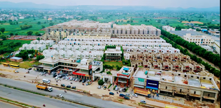
Bhiwadi is a planned city in Khairthal- Tijara district of the Indian state of Rajasthan and a Part of National Capital Region of Delhi.It is located 85 km away from the city of Alwar and situated on the Rajasthan-Haryana border. Bhiwadi is considered to be a hub for Taiwanese and Japanese companies. The city is divided into three separate zones, which are the residential, industrial and commercial zones. In recent years, it also became one of the most polluted cities in the world in terms of air pollution.
Mandawar is a town in the Dausa district in the Indian state of Rajasthan. It is located about 140 km (87 mi) from the state capital, Jaipur and 250 km (160 mi) from Delhi.
Majri is a small size village in Kotkasim tehsil Alwar District in the state of Rajasthan, It is located around 75 km south of Delhi, 75 km north of Alwar, and about 200 km north of Jaipur, the capital of Rajasthan. MAJRI is part of Greater Bhiwadi and National Capital Region (NCR). India.
Kotkasim is a Nagar Palika of Khairtal of the Indian state, Rajasthan.

The Sahibi river, also called the Sabi River, is an ephemeral, rain-fed river flowing through Rajasthan, Haryana and Delhi states in India. It originates in the eastern slopes of the Saiwar Protected Forest (PF) hills in Sikar District, enters Jaipur district near the foot of these hills, and after initially flowing southeast and east turns northeastwards near Shahpura and continues further till it exits Rajasthan to enter Haryana and further drains into Yamuna in Delhi, where its channeled course is also called the Najafgarh drain, which also serves as Najafgarh drain bird sanctuary. It flows for 300 km of which 157 km is in Rajasthan 100 km is in Haryana and 40 km in Delhi.
Mundawar is a Tehsil in Khairthal - Tijara district in Rajasthan State. Mundawar is 40 km from Alwar city.
Khanpur Ahir or Khanpur Aheer is a village in Mundawar Mandal in Alwar district in the Indian state of Rajasthan. Khanpur Ahir is 40 km (25 mi) from its district headquarters, Alwar. It is 140 km (87 mi) from its state capital, Jaipur.
Nasopur is a village in Kotkasim, Tehsil Alwar district, in the Indian state of Rajasthan. It is located around 75 km south of Delhi, 75 km north of Alwar, and about 200 km north of Jaipur, the capital of Rajasthan. Nasopur is part of Greater Bhiwadi and National Capital Region (NCR).
Mahtawas is a village in Neemrana tehsil, Alwar district, Rajasthan state, India. It is a part of the National Capital Region.
Bhojpuri is a small village in Alwar district of Rajasthan in India. It is part of the National Capital Region. It is known for prehistoric havelis. Bhojpuri is 67.3 km far from its District Headquarter Alwar. It is 140 km far from its State Capital Jaipur.
Sanoda is a village in Kotkasim tehsil Alwar District in the state of Rajasthan, India.

Khanpur Dagran, Khanpur Aheeran, Khanpur Ahir is a village in Kotkasim tehsil Alwar District in the state of Rajasthan, India. Khanpur Dagran part of Ahirwal and about 85 percent of the total population are Yadav. Most of the Yadavs belong to the gotra(clan) of the Dagar. The main language spoken in Ahirwati.
Siya Khoh is a small village in the Alwar District of Rajasthan state of India. It comes under the Mundawar tehsil, the Basmenpur gram panchayat, and the Jaipur Division. It is located 45 km towards North from District headquarters Alwar, and 160 km from State capital Jaipur. The PIN code of Siya Khoh is 301407, and the postal office is Basmenpur.
The Trans-Haryana Expressway or the Ambala–Narnaul Expressway (NH-152D) is a 227-km long, 6-lane wide greenfield access-controlled expressway, connecting the cities of Ambala and Narnaul in the state of Haryana. The expressway connects Gangheri village in Kurukshetra district with Surana village on Narnaul Bypass (NH-148B) in Mahendragarh district. It passes via Kaul, Pundri, Assandh, Dhatrath, Kalanaur, Charkhi Dadri and Kanina. It will reduce the distance from Chandigarh to Delhi, Narnaul, and Jaipur, thus decongesting NH-44 and NH-48.

