New Tehri is a city and a municipal board in Tehri Garhwal District in the Indian state of Uttarakhand. It is the administrative headquarters of Tehri Garhwal District. This urban municipality area has 11 wards, from Vidhi Vihar to Vishwakarma Puram.
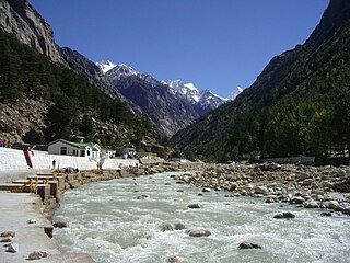
The Bhāgīrathī is a turbulent Himalayan river in the Indian state of Uttarakhand, and one of the two headstreams of the Ganges, the major river of Northern India and the holy river of Hinduism. In the Hindu faith, history, and culture, the Bhagirathi is considered the source stream of the Ganges. However, in hydrology, the other headstream Alaknanda, is considered the source stream on account of its great length and discharge. The Bhagirathi and Alaknanda join at Devprayag in Garhwal and are thereafter known as the Ganges.

Yamunotri, also Jamnotri, is the source of the Yamuna River and the seat of the Goddess Yamuna in Hinduism. It is situated at an altitude of 3,293 metres (10,804 ft) in the Garhwal Himalayas and located approximately 150 kilometres (93 mi) North of Uttarkashi, the headquarters of the Uttarkashi district in the Garhwal Division of Uttarakhand, India. It is one of the four sites in India's Chota Char Dham pilgrimage. The sacred shrine of Yamunotri, source of the river Yamuna, is the westernmost shrine in the Garhwal Himalayas, perched atop a flank of the Bandarpunch mountain. The chief attraction at Yamunotri is the temple devoted to the Goddess Yamuna and the holy thermal springs at Janki Chatti which is 7 km away.

The Alaknanda is a turbulent Himalayan river in the Indian state of Uttarakhand and one of the two headstreams of the Ganges, the major river of Northern India and a river considered holy in Hinduism. In hydrology, the Alaknanda is considered the source stream of the Ganges on account of its greater length and discharge; while, in Hindu tradition and culture, the other headstream, the Bhagirathi, is considered the source stream.

Devprayag is a town and a nagar panchayat, near New Tehri city in Tehri Garhwal District in the state of Uttarakhand, India, and is the final one of the Panch Prayag of Alaknanda River where Alaknanda meets the Bhagirathi river and both rivers thereafter flow on as the Ganges river or Ganga.
Ghansali is located in Ghansali Tehsil of Tehri Garhwal district in Uttarakhand, India. Ghansali town offers a splendid beauty of Bhilangana River on one side and dense forest at other. According to the 2011 census it has a population of 392 living in 82 households. Its main agriculture product is paddy growing.
Uttarakhand is a state in the northern part of India. It is often referred to as the "Devbhumi" due to its religious significance and numerous Hindu temples and pilgrimage sites found throughout the state. As a result, religious tourism forms a major portion of the tourism in the state. Uttarakhand is known for the natural environment of the Himalayas. 2019 Tourist Arrivals Domestic – 40,000,000 per/year and Foreigner – 150,000 per year. Tourism business in Uttarakhand generated ₹ 23,000 crores during 2013–14.
Auden's Col is a high altitude mountain pass connecting Rudugaira valley and Bhilangna valley in India. It is situated at 5,490 metres (18,010 ft) elevation and connects the ridge coming from Gangotri III peak on the north-west and the ridge coming from Jogin I on the east, and also binds a glacier coming from Jogin I on the north side of Rudugaira valley, and deadly Khatling glacier on the south side of Bhilangna valley.
Yogeshwar is a mountain of the Garhwal Himalaya in Uttarakhand, India. The elevation of Yogeshwar is 6,678 metres (21,909 ft) and its prominence is 295 metres (968 ft). It is joint 52nd highest located entirely within the Uttarakhand. Nanda Devi, is the highest mountain in this category. Yogeshwar lies on the ridge between Chaturbhuj 6,654 metres (21,831 ft) and Sri Kailash 6,932 metres (22,743 ft). Its nearest higher neighbor unnamed peak 6,715 metres (22,031 ft) lies 2.7 km N. It is located 2.7 km east of Chaturbhuj 6,654 metres (21,831 ft) and 5 km NW lies Matri 6,450 metres (21,161 ft).
Chaturbhuj is a mountain of the Garhwal Himalaya in Uttarakhand, India. The elevation of Chaturbhuj is 6,654 metres (21,831 ft) and its prominence is 357 metres (1,171 ft). It is 52nd highest located entirely within the Uttrakhand. Nanda Devi, is the highest mountain in this category. Chaturbhuj lies between the Matri 6,721 metres (22,051 ft) and Shwetvarn 6,340 metres (20,801 ft). Its nearest higher neighbor Yogeshwar lies 2.7 km east. It is located 5.9 km NW of chirbas Parbat 6,529 metres (21,421 ft) and 8.5 km east lies Sri Kailash 6,932 metres (22,743 ft).
Devistan I is a mountain of the Garhwal Himalaya located in the Chamoli district of Uttarakhand, India. The elevation of Devistan I is 6,678 metres (21,909 ft) and its prominence is 702 metres (2,303 ft). It is 52nd highest located entirely within the Uttrakhand. Nanda Devi is the highest mountain in this category. It stands on the western rim of the Nanda Devi Sanctuary. It lies between the Devisthan II 6,529 metres (21,421 ft) and Devtoli 6,788 metres (22,270 ft). Its nearest higher neighbor Devtoli 6,932 metres (22,743 ft) lies 6.6 km SSW. It is located 1 km South of Devisthan II and 9.6 km NE lies Nanda Devi 7,816 metres (25,643 ft).
Kirti Stambh is a mountain of the Garhwal Himalaya in Uttarakhand India.The elevation of Kirti Stambh is 6,270 metres (20,571 ft) and its prominence is 100 metres (328 ft). It is 128th highest located entirely within the Uttrakhand. Nanda Devi, is the highest mountain in this category. It lies between Thalaysagar and Bhartekunta. Its nearest higher neighbor Bhartekunta 6,578 metres (21,581 ft) lies 2.3 km SE. It is located 5.1 km SSE of Thalaysagar 6,904 metres (22,651 ft) and 12.8 km NEE lies Bhagirathi I 6,856 metres (22,493 ft).

Bhartekunta is a mountain of the Garhwal Himalaya in Uttarakhand India.The elevation of Bhartekunta is 6,578 metres (21,581 ft) and its prominence is 280 metres (919 ft). It is 69th highest located entirely within the Uttrakhand. Nanda Devi, is the highest mountain in this category. It lies between Kirti Stambh and Kedarnath (mountain). Its nearest higher neighbor Kedarnath (mountain) 6,940 metres (22,769 ft) lies 3 km ESE. It is located 2.3 km SE of Kirti Stambh 6,279 metres (20,600 ft) and 6.9 km north lies Meru Peak 6,660 metres (21,850 ft).
Jogin I is a mountain of the Garhwal Himalaya in Uttarakhand India.The elevation of Jogin I is 6,465 metres (21,211 ft) and its prominence is 843 metres (2,766 ft). It is 94th highest located entirely within the Uttrakhand. Nanda Devi, is the highest mountain in this category. It lies 5.4 km east of Gangotri III and 7.4 km west of Bhrigupanth 6,772 metres (22,218 ft). It lies 2.2 km South of Jogin II. Its nearest higher neighbor is Gangotri III 6,577 metres (21,578 ft). It is located 6.9 km NW of Thalaysagar 6,904 metres (22,651 ft) and 8.8 km NW lies Gangotri I 6,682 metres (21,923 ft).
Jogin II is a mountain of the Garhwal Himalaya in Uttarakhand India.The elevation of Jogin II is 6,342 metres (20,807 ft) and its prominence is 259 metres (850 ft). It is 110th highest located entirely within the Uttrakhand. Nanda Devi, is the highest mountain in this category. It lies 6.2 km east of Gangotri III and 7 km west of Bhrigupanth 6,772 metres (22,218 ft). It lies 2.2 km north of Jogin I. Its nearest higher neighbor is Jogin I 6,465 metres (21,211 ft). It is located 7.2 km NW of Thalay Sagar 6,904 metres (22,651 ft) and 8.5 km NW lies Gangotri I 6,682 metres (21,923 ft).
Jogin III is a mountain of the Garhwal Himalaya in Uttarakhand, India. The elevation of Jogin III is 6,116 metres (20,066 ft). It is 155th highest located entirely within the Uttrakhand. Nanda Devi, is the highest mountain in this category.
Bamchu is a mountain of the Garhwal Himalaya in Uttarakhand India. It's situated on the eastern rim of Nanda Devi Sanctuary on the watershed of Milam Glacier and Nanda Devi basin. The elevation of Bamchu is 6,303 metres (20,679 ft) and its prominence is 241 metres (791 ft). It is 124th highest located entirely within the Uttrakhand. Nanda Devi, is the highest mountain in this category. It lies 3.4 km South of Deo Damla 6,620 metres (21,719 ft) its nearest higher neighbor and 3.1 km SSE of Mangraon 6,568 metres (21,549 ft). Kalanka 6,931 metres (22,740 ft) lies 9.8 km NNW and 9.3 km SW lies Nanda Devi 7,816 metres (25,643 ft).
Srikantha is a mountain of the Garhwal Himalaya in Uttarakhand India. The elevation of Srikantha is 6,133 metres (20,121 ft) and its prominence is 471 metres (1,545 ft). It is 151st highest located entirely within the Uttrakhand. Nanda Devi, is the highest mountain in this category. It lies 5.8 km NW of Gangotri I 6,672 metres (21,890 ft). Jaonli 6,632 metres (21,759 ft) lies 12.3 km SSE and it is 18.6 km west of Manda I 6,510 metres (21,358 ft). It lies 14.4 km NW of Jogin I 6,465 metres (21,211 ft).
Kalidhang is a mountain of the Garhwal Himalaya in Uttarakhand India. It is situated in the Gangotri National Park. The elevation of Kalidhang is 6,373 metres (20,909 ft) and its prominence is 563 metres (1,847 ft). It is joint 105th highest located entirely within the Uttrakhand. Nanda Devi, is the highest mountain in this category. It lies 3 km WNW of Chirbas Parbat 6,529 metres (21,421 ft) its nearest higher neighbor. Matri 6,721 metres (22,051 ft) lies 5.7 km SE and it is 11.8 km NNE of Manda I 6,510 metres (21,358 ft). It lies 10.1 km NNW of Sudarshan Parbat 6,507 metres (21,348 ft).

Kalindi is a mountain of the Garhwal Himalaya in Uttarakhand India. The elevation of Kalindi is 6,102 metres (20,020 ft). It lies 1.1 km North of Avalanche Peak (India) 6,196 metres (20,328 ft) its nearest higher neighbor. Mana Parbat II 6,771 metres (22,215 ft) lies 4.2 km NNW and it is 6.1 km NNE of Chandra Parbat I 6,739 metres (22,110 ft).
