
Uttara Kannada is a district in the Indian state of Karnataka. It is a major coastal district of Karnataka, and is the third largest district in Karnataka. It is bordered by the state of Goa and Belagavi districts to the north, Dharwad District and Haveri District to the east, Shivamogga District, and Udupi District to the south, and the Laccadive Sea to the west.

The Bhima River is a major river in Western India and South India. It flows southeast for 861 kilometres (535 mi) through Maharashtra, Karnataka, and Telangana states, before joining the Krishna River. After the first sixty-five kilometers in a narrow valley through rugged terrain, the banks open up and form a fertile agricultural area which is densely populated.

Kumta is a town and taluk in the Uttara Kannada district of Karnataka, India. It is one of the important stations along the Konkan Railway line running between Mumbai and Mangalore.
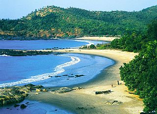
Gokarna is a small temple town located in the Uttara Kannada district of Karnataka state in southern India, It has a population of around 20,000. Shiva is the most worshipped deity in the town. Gokarna's main temple, Mahabaleshwara, is dedicated to Shiva. The temple houses what is believed by some to be the earliest Shiva lingam (Atmalinga).

Sirsi is a city and a taluk headquarter in Uttara Kannada district of Karnataka state in India. It was also known as Kalyana Pattana during the Sonda Dynasty. It is a tourist destination with evergreen forest and waterfalls and is also a commercial centre. The main businesses around the city are mostly subsistence and agriculture-based. Areca nut or betel nut, locally known as Adike, is the primary crop grown in the nearby villages, making it one of the major trading centres for areca nut. The region is also known for spices such as cardamom, pepper, betel leaves, and vanilla. The major food crop is paddy.

The Bhadra is a river in Karnataka state in southern India.
Hukkeri is a Town Municipal Council and taluka in Belgavi district in the Indian state of Karnataka.

The Indian State of Karnataka is located between 11°30' North and 18°30' North latitudes and between 74° East and 78°30' East longitude.It is situated on a tableland where the Western Ghats and Eastern Ghats converge into the complex, in the western part of the Deccan Peninsular region of India. The State is bounded by Maharashtra and Goa States in the north and northwest; by the Lakshadweep Sea in the west; by Kerala in the south-west and Tamil Nadu in the south and south-east, Andhra Pradesh in the south-east and east and Telangana in the north-east. Karnataka extends to about 850 km (530 mi) from north to south and about 450 km (280 mi) from east to west.
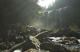
Sathoddi Falls is a picturesque waterfall located in the Western Ghats, Uttara Kannada District Located 32 km (20 mi) from Yellapur and 74 km (46 mi) from Sirsi. It is about 15 metres tall. The stream then flows into the backwaters of the Kodasalli Dam, into the Kali River.
Karnataka's coastline called Karavali stretches 300 km between Mangalore in Dakshina Kannada district and Karwar in Uttara Kannada district. The coastline of Karnataka has been along the eastern shore of Arabian Sea. Karnataka has one major and ten minor ports in this coastal belt. Kali, Belekeri, Gangavali, Aghanashini Sharavathi, Sharabi, Kollur, Gangolli, Sitanadi, Gurpur and Netravati are the important rivers in this belt which empty into the Arabian sea. Sea erosion, migration of river mouths, siltation of ports and harbours are some of the problems common to this belt.

Kodasalli Dam is built across the Kali River (Kalinadi) in Yellapura taluk of Uttara Kannada district of Karnataka state, India. This dam was built by Karnataka Power Corporation Limited. This electric power generating station is classified as hydroelectric power station. It also is a major source of irrigation.

The Kali River or Kaali Nadi is a river flowing through Uttara Kannada district of Karnataka state in India. The river rises near Kushavali, a small village in Uttar Kannada district. The river is the lifeline to some 400,000 people in the Uttara Kannada district and supports the livelihoods of tens of thousands of people including fishermen on the coast of Karwar. There are many dams built across this river for the generation of electricity. One of the important dams build across Kali river is the Supa Dam at Ganeshgudi. The river runs 184 kilometers before joining Arabian Sea.
Holanagadde is a village in the Uttara Kannada district of the state of Karnataka, India. It is located on the west coast beach of the Arabian sea. The main communities that live in the village are Havyakas, Namdharis, Harikanths, Patgars with a few Christian and Mukhri families. The village has a primary school which is more than 160 years old. Rice, cashew nuts, betel nuts and coconuts are the main crops. Carpentry and agriculture are the major occupations in the area.

Tadadi (Tadari) is one of the ports in Uttara Kannada, Karnataka, India. It is near Gokarna in Kumta taluk.

The Gurupura River is a river in the Karnataka state of India. It originates in the Western Ghats and is a tributary of the Netravati River, which empties into the Arabian Sea, south of Mangalore. It gets its name from the town Gurupura, situated near Mangalore. The New Mangalore Port and Mangalore Chemicals and Fertilizers are situated on its northern banks. It once formed northern boundary of Mangalore city along with Netravati River as southern boundary but currently it forms the boundary only for the central part of Mangalore due to the growth of the city beyond these river boundaries.

Aghanashini is a small village situated on the southern banks of River Aghanashini in the state of Karnataka, India., The river Aghanashini originates at 'Shankara Honda' in the Sirsi city. It is one of the virgin rivers of the world. The water from this river flows unobstructed through the western ghats range and then joins the Arabian Sea.

Sadashivgad is a village located in Karwar, Uttara Kannada district, in the state of Karnataka in India. Significant and picturesque, it is now a popular tourist destination located by the Kali river bridge, which has been built at the confluence of the river and the Arabian Sea.
Kundargi is a village in Gokak taluk Belagavi district in Karnataka, India. beside the river Hedkal Dam.

The Shambhavi River has its origins at Kudremukh in Chikkamagaluru district of Karnataka, India. It merges with the Nandini River at Mulki, Karnataka before flowing to the Arabian Sea. This river is the main source of water to many villages nearby the river.
Aghanashini may refer to:
