The Chandragiri or Perumpuzha River is considered the traditional boundary between the Tulu Nadu and Malayalam regions of Kerala.
In 16th-century Portuguese geographies, the Chandragiri River is called the "Rio Cangerecora", and identified as the boundary between the "province of Canará" (Kannada-speaking coastal south Karnataka, vassal of "Bisnaga", Vijayanagara Empire) and the independent kingdoms of "Malabar" (Kerala).[8][9]
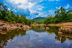
The Chandragiri River basin supports diverse ecosystems typical of the Western Ghats, including tropical wet evergreen forests in the upper reaches and riparian zones with moist deciduous species downstream.[10] The river originates within the Talakaveri Wildlife Sanctuary, a key biodiversity area with endemic flora like the evergreen Hopea ponga and fauna including the lion-tailed macaque, Malabar giant squirrel, and over 250 bird species such as the Malabar whistling thrush.[11] Downstream, it borders the Brahmagiri Wildlife Sanctuary in Kerala, habitat for Asian elephants, Bengal tigers, and amphibians like the Malabar gliding frog in riverine wetlands.[12]
Aquatic biodiversity includes native fish such as the Deccan mahseer and hill trout, vital for local fisheries.[13] Conservation initiatives by the Kerala Forest Department emphasize riparian afforestation and eco-development to address deforestation and erosion risks from high monsoon flows (average annual rainfall ~3,500mm in the basin).[14]
Tributaries
The Chandragiri River receives numerous tributaries originating in the Western Ghats of Kodagu and flowing into Kasaragod. The table below lists all major and minor tributaries documented in official government records.
The Kudumbur River is the longest and most significant tributary, contributing approximately 25% of the Chandragiri's total discharge during peak monsoon.[26] Smaller nullahs and seasonal streams are numerous but not individually mapped in official records.
This page is based on this Wikipedia article Text is available under the CC BY-SA 4.0 license; additional terms may apply. Images, videos and audio are available under their respective licenses.