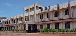
Sullia

Last updated

Sullia
Town
NMC Sullia front view.jpg
Sullia Scene
Nickname: 
Sulya
India Karnataka location map.svg
Red pog.svg
Sullia
Location in Karnataka, India
India location map.svg
Red pog.svg
Sullia
Sullia (India)
Coordinates: 12°33′29″N75°23′21″E / 12.55806°N 75.38917°E / 12.55806; 75.38917
CountryFlag of India.svg  India
State Karnataka
District Dakshina Kannada
Government
  BodyTown Panchayath
   MLA Bhageerathi Murulya
Area
  Town17.13 km2 (6.61 sq mi)
  Rural
809.43 km2 (312.52 sq mi)
Elevation
108 m (354 ft)
Population
 (2011)
  Town19,958 [1]
   Rural
125,269
Time zone UTC+5:30 (IST)
PIN
574239
Telephone code+91 8257
Vehicle registration KA-21
Website http://www.sulliatown.mrc.gov.in/

Sullia (also known as Sulya) is a town in the Dakshina Kannada district of the state of Karnataka, India. It is the headquarters of the Sullia taluk. Sullia is located 300 kilometres west of the state capital Bengaluru.

Contents

History

A historical revolution took place during 1837, when a majority of the Gowdas, Bunts, Kydiyas, Adidravidas and other castes from Amara Sullia, Madikeri, Siddapura, Bhagamandala, Shanivarasanthe, Bellare, Puttur and Nandavara went and fought for freedom against the British. [2] [3] [4] [5] [6]

Members of the Legislative Assembly

YearMemberParty
1972 P. D. Bangera Indian National Congress
1978 A. Ramachandra Janata Party
1983 Bakila Hukrappa Bharatiya Janata Party
1985 K. Kushala Indian National Congress
1969
1994 Angara S. [7] Bharatiya Janata Party
1998
2004
2008
2013
2018
2023 Bhageerathi Murulya Bharatiya Janata Party

Demographics

According to the 2011 census report, Hindus form the largest religious group in Sullia taluk (1,23,507 that is 85.04% of the Taluk population). The number of Muslims is 19,556 (13.47% of the Taluk population) and the number of Christians in the Taluk is 2,076 (1.43%). [8]

Religions in Sullia taluk

Religions in Sullia taluk

source: Sullia Taluk Census 2011 data

  Hindus (90.0%)
  Muslim (8.51%)
  Christians (1.43%)
  Other (0.06%)

Languages in Sullia Taluk

Languages in Sullia taluk [9]
LanguageSpeakers
Tulu
40.9%
Kannada/Arebhashe
19.2%
Malayalam
18.8%
Marathi
13.3%
Others
7.8%
Distribution of languages
Source: 2011 Census of India

Climate

Climate data for Sullia, India
MonthJanFebMarAprMayJunJulAugSepOctNovDecYear
Record high °F841098695109
Mean maximum °F111111
Mean daily maximum °F7790
Mean daily minimum °F6466
Mean minimum °F102102
Record low °F5990646459
Record high °C2943303543
Mean daily maximum °C2532
Mean daily minimum °C1819
Record low °C1532181815
Source 1: [10]
Source 2: [11]

Connectivity

Air

The nearest airport to Sullia is Mangalore International Airport which is at a distance of 88 km. [12] Flights are available to major Indian cities like Delhi, Bangalore, Hyderabad, Chennai, Mumbai and Middle East countries like Abu Dhabi, Bahrain, Dammam, Doha, Dubai–International, Kuwait, Muscat.

Railway

The closest railway station to the city is Subrahmanya Road Railway Station (Station Code:SBHR), which is around 48 km [13] via the fastest road.

See also

Related Research Articles

<span class="mw-page-title-main">Kodagu district</span> District of Karnataka in India

Kodagu district is an administrative district in the Karnataka state of India. Before 1956, it was an administratively separate Coorg State, at which point it was merged into an enlarged Mysore State.

<span class="mw-page-title-main">Madikeri</span> City in Karnataka, India

Madikeri is a hill station town in Madikeri taluk and headquarters of Kodagu district in Karnataka, India. Its original name was Muddurajanakeri which means "the city of Mudduraja".

<span class="mw-page-title-main">Dakshina Kannada</span> District of Karnataka in India

Dakshina Kannada district is located in the state of Karnataka in India, with its headquarters in the coastal city of Mangalore. It is part of the larger Tulu Nadu region. The district covers an area nestled in between the Western Ghats to its east and the Arabian Sea to its west. Dakshina Kannada receives abundant rainfall during the Indian monsoon. It is bordered by Udupi district to the north, Chikmagalur district to the northeast, Hassan district to the east, Kodagu to the southeast and Kasaragod district of Kerala to the south. According to the 2011 census of India, Dakshina Kannada district had a population of 2,083,625. It is the only district in Karnataka state to have all modes of transport like road, rail, water and air due to the presence of a major hub, Mangalore. This financial district is also known as the Cradle of Indian banking.

Arebhashe or Aregannada or Gowda Kannada is a dialect of Kannada mainly by Gowda communities in the region Madikeri, Somwarpet, and Kushalnagar taluks of Kodagu district, Sullia, taluks of Dakshina Kannada district; Bangalore and Mysore districts in the Indian state of Karnataka. As well as Bandadka, Kasaragod District in the Indian state of Kerala, Arebhashe is also called Gowda Kannada. The language was recognized by the Karnataka State government and formed an academy in 2011 to preserve the culture and literature of the Arebhahse Region which is named as Karnataka Arebhashe Samskruthi mathu Sahitya Academy supported by then Chief Minister D. V. Sadananda Gowda.

<span class="mw-page-title-main">Mysore division</span> Administrative division in Karnataka, India

Mysore division, officially Mysuru division, is an administrative division in the southern Indian state of Karnataka. It is one of four administrative divisions in Karnataka, the others being Bangalore division, Belagavi division, and Kalaburagi division. Mysore division comprises eight districts of Karnataka, namely, Chamarajanagar, Chikmagalur, Dakshina Kannada, Hassan, Kodagu, Mandya, Mysore and Udupi district. The city of Mysore is the administrative headquarters of the division. Mysore division covers parts of historical Old Mysore region and southern part of Coastal Karnataka.The total area of the division is 43,503 sq.km. The total population as of 2011 census is 12,563,598.

Thodikana is an Indian village nestled in the foothills of the Western Ghats in southern Karnataka. It is in the Sullia taluk of Dakshina Kannada district, about 100 km from Mangalore city. This village has much greenery and attracts visitors with its cultural and natural sites.

<span class="mw-page-title-main">History of Kodagu</span>

The district of Kodagu in present-day Karnataka comprises the area of the former princely state of the same name.

<span class="mw-page-title-main">Sakleshpur</span> Town in Karnataka, India

Sakleshpur, also known as Sakleshpura or Sakleshapura, is a hill station town and headquarters of Sakleshpur taluk and one of the two Sub-divisional headquarters in Hassan district in the Indian state of Karnataka.

<span class="mw-page-title-main">Kukke Subramanya Temple</span> Hindu temple in Karnataka

Kukke Subramanya is a Hindu temple located in the village Subramanya, of Kadaba taluk in Dakshina Kannada district, Karnataka, India. In this temple Kartikeya is worshipped as Subramanya, lord of all serpents. The epics relate that the divine serpent Vasuki and other serpents found refuge under Subramanya when threatened by the Garuda. The priests in the temple are Shivalli Madhwa Brahmins. The poojas and other daily rituals in the temple are performed as per Madhvacharya's Tantra Sara Sangraha.

Aranthodu is a village in Sulya Taluk of Dakshina Kannada district in Karnataka. It is located 12 km south of Sullia town, towards Madikeri and Mysore. It is located at a distance of 97 km south-east of Mangalore city.

Kadaba is a taluk in Dakshina Kannada district of Karnataka, India. It is located 82 km towards East from District headquarters Mangalore, 31 km from Puttur, 38 km from Sullia and 272 km from State capital Bangalore.

Aletty is a village in the southern state of Karnataka, India. It is located in the Sullia taluk of Dakshina Kannada district in Karnataka.

<span class="mw-page-title-main">Jalsoor</span> Village in Karnataka, India

Jalsoor is a village in Dakshina Kannada district in the south Indian state of Karnataka. This village is major junction connecting three district headquarters; Madikeri, Mangaluru and Kasaragodu. It is one of the main place of trade and transaction in Sullia taluk.

Tulu Gowda and Arebhashe Gowda (Gauda) are primarily found in South Canara District, Kodagu District, Indian state of Karnataka and Bandadka village of Kasaragod. They are officially considered a subsect of the Vokkaliga community but are culturally and linguistically different. They speak Tulu and Arebhashe.

<span class="mw-page-title-main">Panathur</span> Town in Kerala, India

Panathur is a major town in Vellarikundu Taluk of Kasaragod district in Kerala State, India. It belongs to Kanhangad legislative constituency. Its population is about 12,000. It lies 1 km away from Kerala - Karnataka border, 42 km away from the nearest municipality, Kanhangad and 53 km away from the district headquarters, Kasaragod. It is surrounded from three sides by forest reserves and cashew plantations. Kudumbur River flows adjacent to the town.

<span class="mw-page-title-main">Mulleria, Kasaragod</span> Town in Kerala, India

Mulleria is a small town located in Karadka Panchayath, Kasaragod district in Kerala, India.

Kunchadka is a small village in the southern state of Karnataka, India. It is located in the Aletty Village, Sullia taluk of Dakshina Kannada district in Karnataka.

<span class="mw-page-title-main">Amara Sullia Rebellion</span> Armed uprising against British Rule in British India

The Amara Sullia Rebellion was an armed uprising against the British government organized by the people of Arebhashe, and Tulunadu that took place in 1837, twenty years before the Sepoy Mutiny of 1857.

Shishila is a village located at the base of Western Ghats in Belthangady taluk of the Karnataka State, India. The main attraction of the village is a temple dedicated to Lord Shishileshwara.

<span class="mw-page-title-main">Guddemane Appaiah Gowda</span> Indian freedom fighter

Guddemane Appaiah Gowda was an Indian freedom fighter and revolutionary, he instated a peasant army from Kodagu and became its commander in-chief to lead the Amara Sullia Rebellion in 1837. His great grandson Sujith Guddemane is prominent lawyer from Sullia, practising before the High Court of Karnataka. They were successful in hoisting the native flag after lowering the Union Jack, which is known to be the first-ever freedom movement against the East India Company. They established a civil government in Mangalore for 13 days under his leadership.

References

  1. "Census Data Handbook 2011" (PDF). Retrieved 6 October 2023.
  2. "Karnataka / Madikeri News : Appaiah Gowda's feats to be remembered". The Hindu . 31 October 2004. Archived from the original on 12 August 2014.
  3. "Karnataka / Madikeri News : Appaiah Gowda memorial to honour freedom fighter". The Hindu . 19 May 2005. Archived from the original on 4 June 2011.
  4. "Account of an uprising". deccanherald.com. 4 March 2013.
  5. "Fate of the insurgents". deccanherald.com. 4 March 2013.
  6. "DK's new NH to connect three states". The Times of India.
  7. "Karnataka Legislative Assembly Election – 2018". Election Commission of India. Retrieved 4 February 2021.
  8. "Muslim population goes up in DK too: Census report". Deccan Herald . 19 September 2015. Retrieved 16 July 2017.
  9. "Census of India – Language". censusindia.gov.in. Retrieved 23 January 2021.
  10. "Sullia.net". Sullia.net. Retrieved 21 August 2018.
  11. "Google weather". Google weather. Retrieved 21 August 2018.
  12. "Mangaluru International Airport to Sullia". Mangaluru International Airport to Sullia. Retrieved 29 March 2022.
  13. "Subrahmanya Road to Sullia". Subrahmanya Road to Sullia. Retrieved 29 March 2022.