Related Research Articles

Panhala is a city and a Hill station Municipal Council 18 km northwest of Kolhapur, in Kolhapur district in the Indian state of Maharashtra. Panhala is the smallest city in Maharashtra and being a Municipal Council the city is developing rapidly. The city sprawls in the Panhala fort commands a panoramic view of the valley below. The main historical attraction here is the Panhala fort. There are many places of interest, each with its share of haunting anecdotes.
Sangli is a metropolitan town and the headquarters of Sangli District in Maharashtra, in south-western India. It has earned the nickname "Turmeric City of India" for being the hub of the Asia's largest production and trade of this spice. Sangli is situated on the banks of river Krishna and houses many sugar factories. A significant city in South-Western India, it lies 376 km from Mumbai, 230 km from Pune and 638 km from Bangalore. The city has a significant healthcare hub, including its twin City Miraj. Sangli-Miraj combined has more than 1000+ Hospitals and Clinics. Sangli is known as Turmeric city for its global turmeric trade as well grapes, raisins, jaggery and the most significant number of sugar factories in India. The only district has more than 30 sugar factories.The Tasgaon-Sangli region boasts the largest raisin market in Asia. Sangli UA/Metropolitan is one of the biggest cities in Maharashtra and the 93rd biggest in India.Sangli Miraj Kupwad, along with its Urban Agglomeration, together known as Sangli Miraj Kupwad Metropolitan Region (SMKMR).
Kirloskarvadi is India's second oldest industrial township that developed around the Kirloskar Brothers Ltd factory in the Palus, Sangli district, in Maharashtra state, India. It is the second oldest industrial township in India. On 10 March 2010, Kirloskarvadi celebrated 100 years of its establishment. Kirloskarvadi is a rapidly growing satellite suburb of Palus city. The famous holy place of God Datta Maharaj Audumbar is just 10 km away. While Sagareshwar picnic spot is around 8–10. The town has centric connectivity between Satara-Sangli-Kolhapur

Kumbhoj is the name of an ancient town located in Kolhapur district in Maharashtra. The town is about eight kilometers from Hatkanangale, about twenty seven kilometers from Kolhapur and currently, also is the Taluka or Tehsil Headquarters. The famous Jain Tirtha known as Bahubali, is just two kilometers away from the Kumbhoj city.
Kolhapur district is a district in the Maharashtra state of India. The city of Kolhapur is its district headquarter. It is situated near Panchaganga river.
Pune Division is one of the six administrative divisions of the Indian State of Maharashtra. Pune Division is bound by Konkan Division to the west, Nashik Division to the north, Aurangabad Division to the east, and the state of Karnataka to the south.

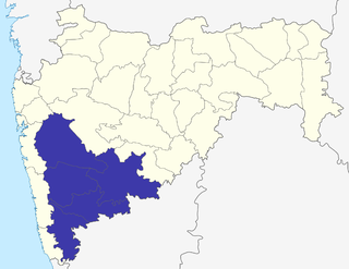
Sangli district is a district of Maharashtra state in India. Sangli city is the district headquarters. It is bordered by Satara district, Solapur district to the North, Karnataka state to the South-East, by Kolhapur district to South-West and by narrow portion on the East side to Ratnagiri district. It is present on the southern tip of Maharashtra.

Shirala also called Battis [32] Shirala is a town and tehsil in Sangli District, India, away 60 kilometres west of the district headquarters, Sangli and about 350 kilometres from Mumbai, capital of Maharashtra state. It is particularly known for its Hindu festival of the snake god.

Karad is a town in Satara district of Indian state of Maharashtra. It is located 302 km (180.19 miles) from Mumbai, 74 km from Sangli and 162 km from Pune. It lies at the confluence of Koyna River and the Krishna River known as the "Pritisangam". The two rivers originate at Mahabaleshwar, which is around 100 km from Karad. Karad is well known for sugar production and is known as the sugar bowl of Maharashtra owing to the presence of many sugar factories in and around Karad. It is considered an important educational hub in Western Maharashtra due to the presence of many prestigious educational institutes. Karad is resting place of the first chief minister of Maharashtra Yashwantrao Chavan situated at the confluence of the Krishna and Koyana rivers. It is ranked as the cleanest town in Swachh Survekshan 2020 in the category of population with less than 1 lakh.

Chandoli National Park is a national park established in Sangli district on May 2004. Earlier it was a Wildlife Sanctuary declared in 1985. Chandoli Park is notable as the southern portion of the Sahyadri Tiger Reserve, with Koyna Wildlife Sanctuary forming the northern part of the reserve

Gaganbawada is a town situated in the district of Kolhapur in Maharashtra, India. It is located 55 km by road from Kankavli. It is one of the taluka headquarters in Kolhapur district.

The word Maharashtra, the land of the mainly Marathi-speaking people, appears to be derived from Maharashtri, an old form of Prakrit. Some believe that the word indicates that it was the land of the Mahars and the Rattas, while others consider it to be a corruption of the term 'Maha Kantara', a synonym for 'Dandakaranya'. Maharashtra is the third largest state in India after Rajasthan and Madhya Pradesh. It covers an area of 307,713 km2 and is bordered by the states of Madhya Pradesh to the north, Chhattisgarh to the east, Telangana to the southeast, Karnataka to the south and Goa to the southwest. The state of Gujarat lies to the northwest, with the Union territory of Dadra and Nagar Haveli sandwiched between the borders. Maharashtra has coastline of 720 km.The Arabian Sea makes up Maharashtra's west coast. Maharashtra consists of two major relief divisions. The plateau is a part of the Deccan tableland and the Konkan coastal strip abutting on the Arabian Sea.
Shahuwadi is a tehsil in the Karvir subdivision of the Kolhapur district in the Indian state of Maharashtra.
Sahyadri Tiger Reserve is a reserve in the state of Maharashtra, created by the Indian government in 2008. Located in the Sahyadri Ranges of the Western Ghats of Maharashtra, it is part of the ecoregions of North Western Ghats moist deciduous forests and North Western Ghats montane rain forests. These ranges form a common boundary between Maharashtra, Karnataka and Goa, and constitute rich evergreen, semi-evergreen and moist deciduous forests. The area is spread over the four districts of Satara, Sangli, Kolhapur and Ratnagiri.
Prachitgad is a fort in the Sahyadri mountain range in Sangli district of Maharashtra state, India. It covers an area of 5 acres (20,000 m2).

The Panchganga River is one of the important rivers of India located in Maharashtra. In English, the name translates as "Five Rivers". It is a major tributary of Krishna River, which it flows into at Narsobawadi.
Nrusinhawadi commonly known as Narsobawadi or Narsobachi Wadi is a small town in Shirol Tahasil in Kolhapur district, Maharashtra. Narsobawadi gets its name from the presence of 'Shri Nrusinha Saraswati', the Purna Avatar of Lord Dattatreya.
Bhilawadi is a town which located in palus taluka. it is near about only 16 km from Palus city. Bhilawadi, located on the bank of Krishna River. This town is one of the prominent producers of Grapes and Sugar Cane in Sangli district. Bhilawadi town has won the Nirmal Gram Purskar in Sant Gadage Baba Gram Swachhata Abhiyan.
Hasur is a village in Maharashtra, India. It is located in the Krishna River basin, in the Desh region. The village is a part of the Shirol taluka of Kolhapur district, Pune Division.
Konavade is a village in Kolhapur, Maharashtra. In ancient times, Konavade was known as Konijavada. Konavade, spelt officially as 'Konvade', is located on the banks of Vedganga, a tributary of the river Panchganga.
References
- ↑ Ganapatye, Shruti (25 August 2019). "Maharashtra flood: Unsung heroes of Sangli who saved over 15,000 lives". Mumbai Mirror . Retrieved 7 March 2021.
- ↑ Mane, Kuldeep (6 August 2020). "Sangli Rain: सांगलीत कृष्णा नदीची पाणी पातळी 20 फुटांच्या वर, वारणा नदीचीही पाणी पातळी वाढली". marathi.abplive.com (in Marathi). Retrieved 7 March 2021.
- ↑ Khot, Sudhakar Sambhaji. Studies on the Impact of Warana River Flood on the Soil Fertility and Socio-Economy of the Region in Kolhapur District (PDF) (Report). Yashwantrao Chavan Warana Mahavidyalaya. Retrieved 7 March 2021.
- ↑ Pathare, S. V.; Panaskar, D. B.; Wagh, V. M.; Pawar, R. S. (2021). "Assessment of Groundwater Quality from Warana River Basin, Kolhapur District, Maharashtra, India". In Pawar, Prashant M.; Balasubramaniam, R.; Ronge, Babruvahan P.; Salunkhe, Santosh B.; Vibhute, Anup S.; Melinamath, Bhuwaneshwari (eds.). Techno-Societal 2020. Cham: Springer International Publishing. pp. 275–284. doi:10.1007/978-3-030-69925-3_28. ISBN 978-3-030-69925-3. S2CID 237962523.