The Godavari is India's second longest river after the Ganga River and drains the third largest basin in India, covering about 10% of India's total geographical area. Its source is in Trimbakeshwar, Nashik, Maharashtra. It flows east for 1,465 kilometres (910 mi), draining the states of Maharashtra (48.6%), Telangana (18.8%), Andhra Pradesh (4.5%), Chhattisgarh (10.9%) and Odisha (5.7%). The river ultimately empties into the Bay of Bengal through an extensive network of distributaries. Measuring up to 312,812 km2 (120,777 sq mi), it forms one of the largest river basins in the Indian subcontinent, with only the Ganga and Indus rivers having a larger drainage basin. In terms of length, catchment area and discharge, the Godavari is the largest in peninsular India, and had been dubbed as the Dakshina Ganga.

The Konkan is a stretch of land by the western coast of India, bound by the river Daman Ganga at Damaon in the north, to Anjediva Island next to Karwar town in the south; with the Arabian Sea to the west and the Deccan plateau to the east. The hinterland east of the coast has numerous river valleys, riverine islands and the hilly slopes known as the Western Ghats; that lead up into the tablelands of the Deccan. The region has been recognised by name, since at least the time of Strabo in the third century CE. It had a thriving mercantile port with Arab tradesmen from the 10th century. The best-known islands of Konkan are Ilhas de Goa, the site of the Goa state's capital at Panjim; also, the Seven Islands of Bombay, on which lies Mumbai, the capital of Maharashtra and the headquarters of Konkan Division.

Thane district is a district in the Konkan Division of Maharashtra, India. At the 2011 Census it was the most populated district in the country, with 11,060,148 inhabitants; however, in August 2014 the district was split into two with the creation of a new Palghar district, leaving the reduced Thane district with a 2011 census population of 8,070,032. The headquarters of the district is the city of Thane. Other major cities in the district are Navi Mumbai, Kalyan-Dombivli, Mira-Bhayander, Bhiwandi, Ulhasnagar, Ambarnath, Badlapur, Murbad and Shahapur.
Palghar is a prominent town in the Konkan division of Maharashtra state, India, and a municipal council. It is Strategically located within the Mumbai Metropolitan Region, and since 2014, it has been the administrative capital of the Palghar district. Palghar plays a crucial role in Western Line of the Mumbai Suburban Railway in the busy Mumbai-Ahmedabad rail corridor. The town is located approximately 87 kilometers north of Mumbai, about 35 kilometers north of Virar, and about 24 kilometers west of the Mumbai-Ahmedabad National Highway at Manor and Mumbai is approximately 50+ km from Palghar.

The Sabarmati River is one of the major west-flowing rivers in India. It originates in the Aravalli Range of the Udaipur District of Rajasthan and meets the Gulf of Khambhat of Arabian Sea after travelling 371 km (231 mi) in a south-westerly direction across Rajasthan and Gujarat. 48 km (30 mi) of the river length is in Rajasthan, while 323 km (201 mi) is in Gujarat.

The Daman Ganga also called the Dawan River is a river in western India. The river's headwaters are on the western slope of the Western Ghats range, and it flows west into the Arabian Sea. The river flows through Maharashtra and Gujarat states, as well as the Union territory of Dadra and Nagar Haveli and Daman and Diu. The industrial towns of Vapi, Dadra and Silvassa lie on the north bank of the river, and the town of Daman occupies both banks of the river's mouth.
Tarapur is a census town in Palghar district in the Indian state of Maharashtra. It is an industrial town located some 45 km north of Virar, on the Western
Datiware is a village in the state of Maharashtra in India on the northern bank of Datiware creek at the mouth of the river Vaitarna. This area is especially famous for its birds and is a popular destination for birdwatchers in winter.

The word Maharashtra, the land of the mainly Marathi-speaking people, appears to be derived from Maharashtri, an old form of Prakrit. Some believe that the word indicates that it was the land of the Mahars and the Rattas, while others consider it to be a corruption of the term 'Maha Kantara', a synonym for 'Dandakaranya'. Maharashtra is the third largest state in India after Rajasthan and Madhya Pradesh. It covers an area of 307,713 km2 and is bordered by the states of Madhya Pradesh to the north, Chhattisgarh to the east, Telangana to the southeast, Karnataka to the south and Goa to the southwest. The state of Gujarat lies to the northwest, with the Union territory of Dadra and Nagar Haveli sandwiched between the borders. Maharashtra has coastline of 720 km.The Arabian Sea makes up Maharashtra's west coast. Maharashtra consists of two major relief divisions. The plateau is a part of the Deccan tableland and the Konkan coastal strip abutting on the Arabian Sea.
Vada or Wada is one of the eight talukas of the Palghar district in the Konkan division of Maharashtra state in India. Centuries ago Wada taluka known as kamalpur It is one of the most industrialised talukas in Palghar district.

Vasai-Virar is an agglomeration of four previously governed municipal councils: Vasai (Bassein), Virar, Nallasopara and Navghar-Manikpur, as well as a few towns to the east and west of the urban area. It lies in the Konkan division of Maharashtra, India.The twin city of Vasai-Virar is a part of the Mumbai Metropolitan Region (MMR) and Mira-Bhayander, Vasai-Virar Police Commissionerate.
The Patalganga River is a river that rises in the steep western scarps of the Matheran uplands where it branches off from the main ridge near Khopoli and maintains a general westward flow till it joins the Dharamtar Creek with a wide estuary. The tail-waters of the Khopoli power project are let into the river near Khopoli in Maharashtra, India. It comes at foremost in terms of pollution. It is one of the most polluted rivers of Maharashtra, source being from Patalganga MIDC. Industries in Patalganga MIDC include. These companies contribute polluting the river. MPCB provides no proper data regarding water quality which is a point which limits the protests from various NGO's and locals. Nowadays, locals from villages on banks of patalganga river complain about the poisoning caused by consuming fishes. Biodiversity of the river is under serious threat due to the harmful chemicals from the dyeing, fertilizer, pesticides, insecticides, alkyl amines industries. Effect of pollution on farming: Crops get burnt due to highly acidic pH of water. Flooding during rainy season results in the flushing of agricultural lands downstream with harmful chemicals which makes land unsuitable for cultivation

Vaitarna Dam, also called Modaksagar Dam, is a Gravity dams on Vaitarna river which supplies water to Palghar, Mumbai, but located in Palghar & Nashik district in the state of Maharashtra in India. It was opened in 1957.

The Sahibi river, also called the Sabi River, is an ephemeral, rain-fed river flowing through Rajasthan, Haryana and Delhi states in India. It originates in the eastern slopes of the Saiwar Protected Forest (PF) hills in Sikar District, enters Jaipur district near the foot of these hills, and after initially flowing southeast and east turns northeastwards near Shahpura and continues further till it exits Rajasthan to enter Haryana and further drains into Yamuna in Delhi, where its channeled course is also called the Najafgarh drain, which also serves as Najafgarh drain bird sanctuary. It flows for 300 km of which 157 km is in Rajasthan 100 km is in Haryana and 40 km in Delhi.

Boisar is the largest industrial suburb in the Mumbai Metropolitan Region in the Indian state of Maharashtra. It was originally a part of the Thane district before becoming a part of the Palghar district. It is approximately 111 kilometers away from the state capital Mumbai, and is 98 km (61 mi) from the union territory Daman. It is located in the district Palghar in Maharashtra.

Palghar District is a district in the state of Maharashtra in Konkan Division. The headquarters of the district is the town of Palghar. Other major cities in the district are Vasai-Virar, Talasari, Jawhar and Dahanu.

Vasai Assembly constituency is one of the 288 Vidhan Sabha constituencies of Maharashtra state in western India. It is one of the six Vidhan Sabha constituencies located in Palghar district.

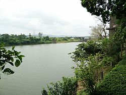
Tandulwadi Fort is located near Saphale, 104 km north of Mumbai. Tandulwadi is not a fully built up fort, but a series of structures spread over the top of the mountain. The fort dates back 800 years and was primarily used as a watch tower over the surrounding plains. At a height of 1524 feet, it has views of the surrounding towns of Saphale, the Zanzorli lake, and the confluence of the Surya and Vaitarna rivers.

Asheri Fort / Asheri is a fort located 102 km from Mumbai and 88 km from Thane. It is in Palghar district, of Maharashtra. This fort is an important fort in Palghar district. The fort is located on the hills near Mendhavan Khind on Mumbai-Ahmedabad highway. The base village Khodkona is a very small tribal village. The Fort restoration is done by the local villagers.
Dativare Fort / Hira Dongar is a fort located 72 km from Vasai, in Palghar district, of Maharashtra, India. The fort is located at a commanding point upon a small hillock beside the Vaitarna River, which runs until Arnala Fort.