Koundinya Wildlife Sanctuary

Last updated

Koundinya Wildlife Sanctuary
IUCN category IV (habitat/species management area)
Andhra Pradesh - Landscapes from Andhra Pradesh, views from Indias South Central Railway (77).JPG
View of a part of the Sanctuary
India Andhra Pradesh location map (current).svg
Red pog.svg
Location of Koundinya Wildlife Sanctuary in Andhra Pradesh, India.
Location Andhra Pradesh, India
Nearest city Chittoor
Coordinates 13°01′30″N78°38′42″E / 13.02500°N 78.64500°E / 13.02500; 78.64500 Coordinates: 13°01′30″N78°38′42″E / 13.02500°N 78.64500°E / 13.02500; 78.64500 [1]
Area357.6 km2 (88,400 acres)
EstablishedDecember 1990
Governing body Andhra Pradesh Forest Department
Asian elephant Working Elephant Vietnam.jpg
Asian elephant

Kaundinya Wildlife Sanctuary is a wildlife sanctuary and an elephant reserve situated in Andhra Pradesh, India. It is the only sanctuary in Andhra Pradesh with a population of Asian elephants, which migrated after 200 years from neighbouring regions. [2]

Contents

History

Kaundinya is a region to which elephants have returned after 200 years. In the last decade, elephants have been migrating more than ever before, looking for habitable forests. From 1983 to 1986, a sizable number of elephants began their journey from the forests of Anekal-Hosur in Tamil Nadu and Bannerghatta in Karnataka to seek alternative homes in other regions. Thirty-nine of the elephants moved to the forests of Andhra Pradesh, a state which had no elephants before. This led to the government setting up the sanctuary in December 1990. Today it is home to about 72 elephants. [2] [3]

Geography

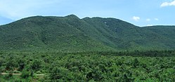
The habitat of Kaundinya sanctuary is rugged with high hills and deep valleys. The sanctuary has dry deciduous forests with thorny scrubs interspersed with trees. These forests have small ponds, tanks and the Kaindinya and Kaigal tributaries of Palar River. The sanctuary is situated in region where the Kolar Plateau ends and slopes down into the plains of Tamil Nadu creating many valleys and ghats. [3]

Kalyan Revu Water Falls

Kalyan Revu Water Falls Kalyan Revu.jpg
Kalyan Revu Water Falls

Kalyana Revu WaterFalls (also called Kalyan Drive Falls) is a waterfall located to the North of Palamaner in the Chittoor district of India in the Koudinya Wildlife Sanctuary. The falls are located 10 kilometres from Palamaner.

Kaigal Water Falls

Kaigal Waterfalls is a waterfall located to the west of Palamaner in the Chittoor district of India in the Koudinya Wildlife Sanctuary. The falls are located 28 kilometres from Palamaner and 10 km from V.Kota. It lies between Palamaner and Kuppam national highway.

Flora and fauna

The sanctuary is covered by southern tropical dry deciduous and thorn forests. Some of the important flora consists of Albizia amara , Acacia , Lagerstroemia , Ficus , bamboo, and a species which is a regeneration of Santalum album . [1]

The sanctuary is primarily an elephant reserve and is home to about 78 Indian elephants. The vulnerable yellow-throated bulbul is present in the sanctuary. Some of the other animals found in the sanctuary are sloth bear, panther, cheetal, chowsingha, sambar, porcupine, wild boar, jungle cat, jackal, jungle fowl, starred tortoise and slender loris. [1]

Threats and conservation issues

The threats faced in the sanctuary are man-animal conflict, over-grazing, illegal collection of wood. Insufficient fodder in the forest due to over-grazing by livestock, and availability of crops like sugarcane, sorghum and ragi attracts elephants, resulting in man-animal conflict. As of 2002, 42 people have been killed by elephants, and 12 elephants have been electrocuted to death by local population. [2]

Kalyani Dam in Chamala Valley, a part of Sri Venkateswara National Park, in Tirupati is a good habitat for elephants. A corridor for elephants is being planned between Koundinya Wildlife Sanctuary and Sri Venkateswara National Park under Project Elephant. [2]

Related Research Articles

<span class="mw-page-title-main">Eastern Ghats</span> Mountain range along the eastern coast of India

The Eastern Ghats are a discontinuous range of mountains along India's eastern coast. The Eastern Ghats pass through Odisha, Andhra Pradesh to Tamil Nadu in the south passing some parts of Karnataka as well as Telangana. They are eroded and cut through by four major rivers of peninsular India, viz., Mahanadi, Godavari, Krishna, and Kaveri. Deomali with 1672 m height is the tallest point in Odisha. Arma Konda/Jindhagada Peak with 1680 m is the highest point in Andhra Pradesh. BR hill range located in Karnataka is the tallest hill range in Eastern Ghats with many peaks above 1750 m height. Kattahi betta in BR hills with the height of 1822 m is the tallest peak in Eastern Ghats. Thalamalai hill range in Tamil Nadu is the second tallest hill range. Araku range is the third tallest hill range.

<span class="mw-page-title-main">Kuppam</span> Municipality in Andhra Pradesh, India

Kuppam is a Granite City of Andhra Pradesh. Kuppam is a Municipality in Chittoor district of the Indian state of Andhra Pradesh located 115.8 kilometers South-East of Bangalore, the Capital City of Karnataka and 243 kilometers West of Chennai the Capital City of Tamil Nadu. It is the Mandal Headquarters of Kuppam Mandal in Kuppam Revenue Division. The name 'Kuppam' Means a meeting place or confluence.

<span class="mw-page-title-main">Sri Venkateswara National Park</span> National park in Andhra Pradesh, India

Sri Venkateswara National Park is a national park and biosphere reserve in Tirupati of Andhra Pradesh, India. The total area of the park is 353 km2. The park is known for its many waterfalls, including the Talakona, Gundalakona and Gunjana. As the government of India declared the Seshachalam Hills as one of the biosphere reserves of India in 2010, this national park becomes the part of it.

<span class="mw-page-title-main">Deccan thorn scrub forests</span> Ecoregion of India and Sri Lanka

The Deccan thorn scrub forests are a xeric shrubland ecoregion of south India and northern Sri Lanka. Historically this area was covered by tropical dry deciduous forest, but this only remains in isolated fragments. The vegetation now consists of mainly of southern tropical thorn scrub type forests. These consist of open woodland with thorny trees with short trunks and low, branching crowns; spiny and xerophytic shrubs; and dry grassland. This is the habitat of the great Indian bustard and blackbuck, though these and other animals are declining in numbers; this area was at one time home to large numbers of elephants and tigers. Almost 350 species of bird have been recorded here. The remaining natural habitat is threatened by overgrazing and invasive weeds, but there are a number of small protected areas which provide a haven for the wildlife. Trees in these forests have adapted to not require much water.

Kaigal water falls is situated in the Chittoor district of Andhra Pradesh state, India and is surrounded by the Koundinya Wildlife Sanctuary.

Palamaner or Palamaneru is a town in Chittoor district of the Indian state of Andhra Pradesh. It is the mandal headquarters of Palamaner mandal and Palamaner Revenue Division

<span class="mw-page-title-main">Chinnar Wildlife Sanctuary</span> Wildlife sanctuary in South India

Chinnar Wildlife Sanctuary is located 18 km north of Marayoor on State Highway 17 in the Marayoor and Kanthalloor panchayats of Devikulam taluk in the Idukki district of Kerala state in South India. It is one of 18 wildlife sanctuaries among the protected areas of Kerala.

<span class="mw-page-title-main">Central Deccan Plateau dry deciduous forests</span>

The Central Deccan Plateau dry deciduous forests in Western and Southern India, containing large protected areas of natural tiger habitat.

<span class="mw-page-title-main">Pathikonda</span> Village in Andhra Pradesh, India

Pathikonda is a village in Gangavaram mandal in Chittoor district in the state of Andhra Pradesh in India.

<span class="mw-page-title-main">Andhra Pradesh Forest Department</span>

Andhra Pradesh Forest Department is one of the administrative divisions of Government of Andhra Pradesh. It is headed by the Principal Chief Conservator of Forests, Head of Forest Force. The primary function of this department is protection, conservation and management of forests in the Andhra Pradesh State. The Forest Department is organized into 12 territorial circles and 43 divisions. In addition, one Senior Officer of the rank of Deputy Conservator of Forests functions as Planning and Extension Officer in each district.

<span class="mw-page-title-main">Tourism in Andhra Pradesh</span>

Andhra Pradesh is a state in India. Andhra Pradesh Tourism Development Corporation (APTDC) is a state government agency which promotes tourism in Andhra Pradesh, describing the state as the Koh-i-Noor of India. Andhra Pradesh has a variety of tourist attractions including beaches, hills, caves, wildlife, forests and temples.

<span class="mw-page-title-main">Geography of South India</span>

The Geography of South India comprises the diverse topological and climatic patterns of South India. South India is a peninsula in the shape of a vast inverted triangle, bounded on the west by the Arabian Sea, on the east by the Bay of Bengal and on the north by the Vindhya and Satpura ranges.

Talakona is situated in Tirupati district of Andhra Pradesh, India. It is a resort with waterfalls, dense forests and wildlife. Talakona waterfall is in Sri Venkateswara National Park, Tirupati district of Andhra Pradesh. With a 270 feet (82 m)-fall, Talakona is the highest waterfall in Andhra Pradesh state. Talakona is also known for the Lord Siddheswara Swamy Temple, which is located close to the waterfall.

<span class="mw-page-title-main">Ratapani Tiger Reserve</span> Tiger reserve in India

The Ratapani Tiger Reserve, located in the Raisen district of Madhya Pradesh, in Vindhya Range in central India, is one of the finest teak forests in the state and is less than 50 kilometres (31 mi) away from the capital Bhopal.

<span class="mw-page-title-main">Sathyamangalam Tiger Reserve</span> Tiger Reserve in Tamil Nadu, India

Sathyamangalam Tiger Reserve is a protected area and tiger reserve in the Eastern Ghats in the Erode District of the Indian state of Tamil Nadu. It has a tiger population of 83 individuals and a leopard population of 111 individuals according to the 2019 census.

<span class="mw-page-title-main">Sigur Plateau</span> Reserve forest in Tamil Nadu, India

Sigur Plateau is a plateau in the north and east of Nilgiri District in the Nilgiri Hills of Tamil Nadu, South India. It covers the 778.8 square kilometres (300.7 sq mi) portion of the Moyar River drainage basin on the northern slopes of the Nilgiri Hills, south of the Moyar River.

<span class="mw-page-title-main">Natural vegetation and wildlife of Andhra Pradesh</span>

The state of Andhra Pradesh is considered one of the rich 123 bio-diversified states in India. Natural vegetation (flora) and animal life (fauna) depend mainly on climate, relief, and soil. Krishna and Godavari are the two largest rivers flowing through the state. The Andhra Pradesh Forest Department deals with protection, conservation and management of forests.

<span class="mw-page-title-main">Tourism in India by state</span>

Tourism in India is economically important and ever growing. The World Travel & Tourism Council calculated that tourism generated 14.02 lakh crore (US$180 billion) or 9.6% of the nation's GDP in 2016 and supported 40.343 million jobs, 9.3% of its total employment. The sector is predicted to grow at an annual rate of 6.8% to 28.49 lakh crore (US$360 billion) by 2027. Various states and union territories of India attract tourists from all over the world, mainly due to the cultural diversity.

<span class="mw-page-title-main">Tirupati district</span> District in Andhra Pradesh, India

Tirupati district is one of the twenty-six districts in the Indian state of Andhra Pradesh and one of the eight districts in the Rayalaseema region of the Andhra Pradesh state. The district headquarters is located at Tirupati city. Tirupati district is known for its numerous historic temples, including the Hindu shrine of Tirumala Venkateswara Temple, Sri Kalahasteeswara temple and many others.The district is also home to Satish Dhawan Space Centre, a rocket launch centre located in Sriharikota and operated by Indian Space Research Organisation (ISRO). The river Swarnamukhi flows through Srikalahasti and joins with the Bay of Bengal in this district. Industries include groundnuts and paddy fields.

References

  1. 1 2 3 "APFD Website". Forest.ap.nic.in. Archived from the original on 21 May 2012. Retrieved 30 July 2012.
  2. 1 2 3 4 "Archived copy" (PDF). Archived from the original (PDF) on 11 April 2013. Retrieved 30 July 2012.{{cite web}}: CS1 maint: archived copy as title (link)
  3. 1 2 "Metro Plus Chennai / Travel : Kaundinya Wildlife Sanctuary". The Hindu . 30 July 2005. Archived from the original on 29 June 2006. Retrieved 30 July 2012.

Commons-logo.svg Media related to Koundinya Wildlife Sanctuary at Wikimedia Commons