
India is situated north of the equator between 8°4' north to 37°6' north latitude and 68°7' east to 97°25' east longitude. It is the seventh-largest country in the world, with a total area of 3,287,263 square kilometres (1,269,219 sq mi). India measures 3,214 km (1,997 mi) from north to south and 2,933 km (1,822 mi) from east to west. It has a land frontier of 15,200 km (9,445 mi) and a coastline of 7,516.6 km (4,671 mi).

Côte-d'Or is a department in the Bourgogne-Franche-Comté region of Northeastern France. In 2016, it had a population of 533,213. Its prefecture is Dijon and subprefectures are Beaune and Montbard.

The Loess Plateau,, is a 640,000 km2 (250,000 sq mi) plateau in north/northwest China with an elevation of 1,250–2,000 m (4,100–6,560 ft), located around the southern half of the Yellow River's Ordos Loop and the valleys of its two largest tributaries, the Wei and Fen Rivers. The Loess Plateau covers almost all of the provinces of Shaanxi and Shanxi and extends into parts of Henan, Gansu, Ningxia and Inner Mongolia. It was enormously important to Chinese history, as it formed one of the early cradles of Chinese civilization and its eroded silt is responsible for the great fertility of the North China Plain, along with the repeated and massively destructive floods of the Yellow River. Its soil has been called the "most highly erodible... on earth" and conservation efforts and land management are a major focus of modern Chinese agriculture.
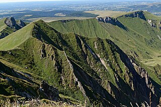
The Massif Central is a highland region in the middle of Southern France, consisting of mountains and plateaus. It covers about 15% of mainland France.

The Deccan Plateau is a large plateau in western and southern India. It rises to 100 metres (330 ft) in the north, and to more than 1,000 metres (3,300 ft) in the south, forming a raised triangle within the south-pointing triangle of the Indian coastline.

The Hexi Corridor (Chinese: 河西走廊; pinyin: Héxī Zǒuláng; Wade–Giles: Ho2-hsi1 Tsou3-lang2, Xiao'erjing: حْسِ ظِوْلاْ, IPA: /xɤ˧˥ɕi˥ tsoʊ˨˩˦lɑŋ˧˥/), also known as the Gansu Corridor, is an important historical region located in the modern Gansu province of China, referring to a narrow stretch of traversable and relatively arable plain west of the Yellow River's Ordos Loop (hence the name Hexi, meaning "west of the river"), flanked between the much more elevated and inhospitable terrains of the Mongolian and Tibetan Plateaus.

The Ustyurt or Ust-Yurt is a transboundary clay desert shared by Turkmenistan, Uzbekistan and Kazakhstan.

Chomérac is a commune in the Ardèche department in southern France.
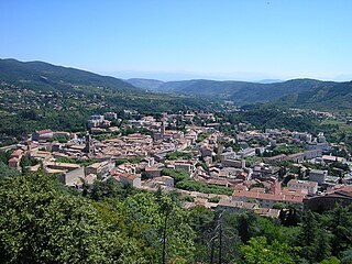
Privas is a commune of France, capital of the Ardèche department. It is the smallest administrative centre of any department in France. It is the fifth-largest commune in the Ardèche, behind Annonay, Aubenas, Guilherand-Granges, and Tournon-sur-Rhône. It was the location of the 1629 Siege of Privas. Today Privas is known for the purée made from the local chestnuts, and for its sweetened marron glacé.
The province of Catanzaro is a province of the Calabria region of Italy. The city Catanzaro is both capital of the province and capital of the region of Calabria. The province contains a total of 80 municipalities (comuni). Its provincial president is Sergio Abramo.

Penna is a river of southern India. The Penna rises in the Nandi Hills in Chikkaballapur District of Karnataka state, and runs north and east through the states of Karnataka and Andhra Pradesh to empty into the Bay of Bengal. It is 597 kilometres (371 mi) long, with a drainage basin covering 55,213 km2: 6,937 km2 in Karnataka and 48,276 km2 in Andhra Pradesh. The river basin lies in the rain shadow region of Eastern Ghats and receives 500 mm average rainfall annually.

Palar is a river of southern India. It rises in the Nandi Hills in Chikkaballapura district of Karnataka state, and flows 93 kilometres (58 mi) in Karnataka, 33 kilometres (21 mi) in Andhra Pradesh and 222 kilometres (138 mi) in Tamil Nadu before reaching its confluence into the Bay of Bengal at Vayalur about 100 kilometres (62 mi) south of Chennai. It flows as an underground river for a long distance only to emerge near Bethamangala town, from where, gathering water and speed, it flows eastward down the Deccan Plateau. The Towns of Bethamangala, Santhipuram, Kuppam, Ramanaickenpet, Vaniyambadi, Ambur, Melpatti, Gudiyatham, Pallikonda, Melmonavoor, Vellore, Katpadi, Melvisharam, Arcot, Ranipet, Walajapet, Kanchipuram, Walajabad, Chengalpattu, Kalpakkam, and Lattur are located on the banks of the Palar River. Of the seven tributaries, the chief tributary is the Cheyyar River.
The Mysore Plateau, also known as the South Karnataka Plateau, is a plateau that is one of the four geographically unique regions of the Indian state of Karnataka. It has many undulations and is bounded on the west and south by the Western Ghats. Most of the river Kaveri flows through Karnataka in the Mysore Plateau. The average elevation in the region is between 600–900 meters. The plateau covers the districts of Bangalore, Bangalore Rural, Chamarajanagar, Hassan, Kodagu, Kolar, Mandya, Mysore and Tumkur. The name of the plateau is derived from Karunadu. The plateau has an area of about 73,000 square miles and an average elevation of about 2,600 feet. It consists of the Dharwar system of volcanic rocks, crystalline schists, and granites. The major rivers include the Godavari, Krishna, Kaveri, Tungabhadra, Sharavati, and Bhima. The Sharavati has the famous waterfall known as Jog Falls. These falls are one of the most important sources of hydroelectric power in the country and are also a major tourist attraction. The plateau merges with the Nilgiri Hills in the south. Rainfall varies from 80 inches (2,030 mm) in the southern hills to 28 inches (710 mm) in the northern region.
The Mysore region is an unofficial region that is part of Karnataka state in southern India. It forms approximately the southern half of the non-coastal areas of that state. The area corresponds almost exactly to that of the erstwhile princely state of Mysore. Almost all of that principality, with the exception of a few areas that now lie in neighbouring states, is comprehended by this term.
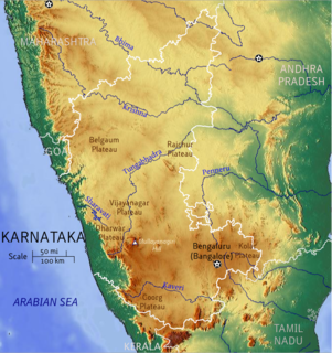
Bayaluseeme or Bayalu Seeme is the area lying to the east of Malenadu, a region of Karnataka state in India. The area is largely open plain, with few hillocks. It includes the districts of Bangalore, Bagalkot, Bijapur, Chitradurga, Davanagere, Dharwad, Gadag, Hassan, Haveri, Mandya, Mysore, Tumkur.

Chintamani is a Taluk Headquarters in the Indian state of Karnataka. Located on the Deccan Plateau in the south-eastern part of Karnataka. Chintamani is one of the well planned and developed Towns in the District of Kolar and presently Chikkaballapur. Chintamani is known for its Silk and Tomato production and their largest markets in Karnataka.

An Agraharam or Agrahara was a grant of land and royal income from it, typically by a king or a noble family in India, for religious purposes, particularly to Brahmins to maintain temples in that land or a pilgrimage site and to sustain their families. Agraharams were also known as Chaturvedimangalams in ancient times. They were also known as ghatoka, and boya. Agraharams were built and maintained by dynasties such as the Cholas and Pallavas.
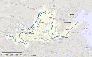
The Ordos Plateau, also known as the Ordos Basin or simply the Ordos, is a highland sedimentary basin in northwest China with an elevation of 1,000–1,600 m (3,300–5,200 ft), and consisting mostly of land enclosed by the Ordos Loop, a large northerly rectangular bend of the Yellow River that makes up the river's entire middle section. It is China's second largest sedimentary basin with a total area of 370,000 km2 (140,000 sq mi), and includes territories from five provinces, namely Shaanxi, Gansu, Ningxia, Inner Mongolia and a thin fringe of Shanxi, but is demographically dominated by the former three, hence is also called the Shaan-Gan-Ning Basin. The basin is bounded in the east by the Lüliang Mountains, north by the Yin Mountains, west by the Helan Mountains, and south by the Huanglong Mountains, Meridian Ridge and Liupan Mountains.