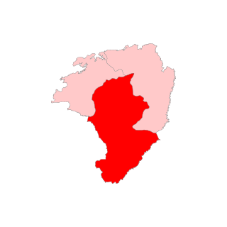
Karbi Anglong district is an administrative unit in the Indian state of Assam. It is an autonomous district administered by the Karbi Anglong Autonomous Council (KAAC) according to the provisions of the Sixth Schedule of the constitution of India. The district headquarters is in Diphu.

Dima Hasao district, is an administrative district in the state of Assam, India. As of 2011, it is the least populous district of Assam.
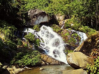
Diphu is the headquarter of Karbi Anglong district in the state of Assam in India. This small town is a popular tourist hill station for people of nearby cities.

The Karbis or Mikir are one of the major ethnic community in Northeast India. They are mostly concentrated in the hill districts of Karbi Anglong and West Karbi Anglong of Assam.
Autonomous District Lok Sabha constituency is one of former Lok Sabha constituencies in the Indian state of Assam. The constituency consists of three autonomous districts namely Dima Hasao, Karbi Anglong and West Karbi Anglong district.
Bokajan is a town in Karbi Anglong district in the state of Assam, India. Bokajan is best known for its Cement factory. It is 15 km away from Dimapur and partially borders Nagaland.
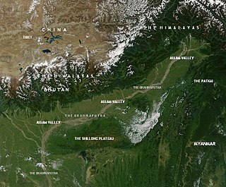
This article discusses the geological origin, geomorphic characteristics, and climate of the northeastern Indian state of Assam. Extending from 89° 42′ E to 96° E longitude and 24° 8′ N to 28° 2′ N latitude, it has an area of 78,438 km2, similar to that of Ireland or Austria.
Mikir Hills are a group of hills located to the south of the Kaziranga National Park, Assam. The easternmost Meghalaya comprising the detached Mikir Hills is partly isolated being surrounded by three sides. Karbi plateau or Mikir Hills is known oldest landform in Assam. It is pear-shaped and has an area of about 7000 sq. km.

The Dhansiri is a river of Golaghat District of Assam and the Chümoukedima District and Dimapur District of Nagaland. It originates from Laisang peak of Nagaland. It flows through a distance of 352 kilometres (219 mi) from south to north before joining the Brahmaputra on its south bank. Its total catchment area is 1,220 square kilometres (470 sq mi).
Karbi-Meghalaya plateau is, in fact, an extension of the main Indian peninsular plateau and are originally two different plateaus - Karbi Anglong Plateau and Meghalaya plateau.

Kaziranga National Park is an Indian national park and a World Heritage Site in Golaghat and Nagaon districts of Assam, India. It is refuge for the world's largest population of Great One-horned Rhinoceros. The park has many elephant, water buffalo and swamp deer. It is recognized as an Important Bird Area by BirdLife International for conservation of avifaunal species. The park has achieved notable progress in wildlife conservation despite several constraints.

The Karbi language is a Tibeto-Burman language spoken by the Karbi people of Northeastern India.

Kopili River is an interstate river in Northeast India that flows through the states of Meghalaya and Assam and is the largest south bank tributary of the Brahmaputra in Assam.
Karbi Anglong Baptist Convention (KABC) is a Baptist Christian denomination based in Assam, India. It is affiliated with the Council of Baptist Churches in Northeast India and the Asia Pacific Baptist Federation.

The West Karbi Anglong district is an administrative unit in the Indian state of Assam. It is a relatively new district formed out of the existing Karbi Anglong district in 2016. The administrative headquarters of the district is located at Hamren. The district is a part of the Karbi Anglong Autonomous Council and is administered according to the provisions of the Sixth Schedule of the Indian Constitution.

Bokajan Assembly constituency is one of the 126 constituencies of the Assam Legislative Assembly in India. Bokajan forms a part of the Autonomous District Lok Sabha constituency. This seat is reserved for the Scheduled Tribes (ST).
Diphu is one of the 126 constituencies of the Assam Legislative Assembly in India. Diphu forms a part of the Autonomous District Lok Sabha constituency. This seat is reserved for the Scheduled Tribes (ST).

Baithalangso Assembly constituency is one of the 126 constituencies of the Assam Legislative Assembly in India. Baithalangso is in West Karbi Anglong district of Assam and forms a part of the Autonomous District Lok Sabha constituency. This seat is reserved for the Scheduled Tribes (ST).

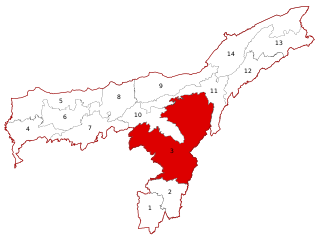
Karbi Anglong Autonomous Council (KAAC) is an autonomous district council in the state of Assam, India for development and protection of tribals living in area namely Karbi Anglong and West Karbi Anglong district. The council is constituted under the Sixth Schedule of the Constitution of India and administratively functions under the Government of Assam. It was formed with the name Karbi Anglong District Council on 17 November 1951. Later changed to Karbi Anglong Autonomous Council on 23 June 1952, which is now celebrated as its foundation day. After Signing of M.O.U. between Government of India, Government of Assam and United People's Democratic Solidarity, it was renamed to Karbi Anglong Autonomous Territorial Council. It has administrative functions over two district, Karbi Anglong district and West Karbi Anglong district. Its headquarters is in Diphu, Karbi Anglong district. The total area of the Karbi Anglong Autonomous Council is 10,434 sq. km having a population of 961,275 as of 2011.

Deopani Durga Mandir is a Hindu Shakta temple of Goddess Durga situated in Asean highway 1, Borsewaguri, Bokajan, Karbi Anglong, Assam, India – 782470.