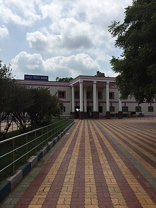
Nandyal is a city and District headquarters of Nandyal district of the Indian state of Andhra Pradesh. It is a municipality and the headquarters of Nandyal mandal in Nandyal revenue division.
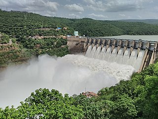
The Srisailam Dam is constructed across the Krishna River in Nagarkurnool district, Telangana and Nandyal district, Andhra Pradesh near Srisailam temple town and is the 2nd largest capacity working hydroelectric station in India.
Nagarkurnool Lok Sabha constituency is one of the 17 Lok Sabha constituencies in Telangana state in southern India. This constituency is reserved for the candidates belonging to the Scheduled castes.
Achampet is a town and municipality in Nagarkurnool district of the Indian state of Telangana. The town is a revenue division headquarters. Achampet is located in the foothills of the Nallamala Forest.
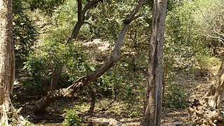
The Central Deccan Plateau dry deciduous forests in Western and Southern India, containing large protected areas of natural tiger habitat.

Dornala is a village in Prakasam district of the Indian state of Andhra Pradesh. It is the mandal headquarters of Dornala mandal in Markapur revenue division.
Domah or Doma is a mandal in Vikarabad district of Telangana, India.
Nagarjunsagar-Srisailam Tiger Reserve is the largest tiger reserve in India. The reserve spreads over five districts, Kurnool District, Prakasam District, Guntur District, Nalgonda District and Mahabub Nagar district. The total area of the tiger reserve is 3,728 km2 (1,439 sq mi). The core area of this reserve is 1,200 km2 (460 sq mi). The reservoirs and temples of Srisailam are major attraction for many tourists and pilgrims. It is the largest tiger reserve forest in India and is located inside Nallamala forest area.

The Nallamalas are a section of the Eastern Ghats which forms the eastern boundary of Rayalaseema region of the state of Andhra Pradesh and Nagarkurnool district of the state of Telangana, in India. They run in a nearly north–south alignment, parallel to the Coromandel Coast for close to 430 km between the rivers, Krishna and Pennar. Its northern boundaries are marked by the flat Palnadu basin while in the south it merges with the Tirupati hills. An extremely old system, the hills have extensively weathered and eroded over the years. The average elevation today is about 520 m which reaches 1100 m at Bhairani Konda and 1048 m at Gundla Brahmeswara. Both of these peaks are in a north westerly direction from the town of Cumbum. There are also many other peaks above 800m.
Buthpur or Bhoothpur is a large area in Mahbubnagar district, Telangana.

Koderu or Kodair is a village and mandal headquarters in Nagar Kurnool district, Telangana, India.
Makthal is a Mandal in Narayanpet district, Telangana. It is also an assembly constituency in the Telangana Legislative Assembly.
Tadoor is a Mandal in Nagarkurnool district, Telangana. Tadoor Mandal Headquarters is Tadoor village. It is located 54 km towards East from District headquarters Nagarkurnool. 113 km from State capital Hyderabad towards North.
Mahatma Gandhi Kalwakurthy lift irrigation scheme (MGKLIS) is a lift irrigation project on River Krishna located in Mahbubnagar district in the Indian state of Telangana. The lift canal starts from the backwaters of Srisailam Dam near Kollapur. The gravity driven, 100 kilometer-long canal provides cultivation for nearly 137,000 hectares (340,000 acres)in 300 villages located in constituencies of Kollapur, Wanaparthy, Nagarkurnool, Kalwakurthy, Jadcherla, and Achampet.
Mahbubnagar Assembly constituency is a constituency of Telangana Legislative Assembly, India. It is one of 14 constituencies in Mahbubnagar district and it includes Mahabubnagar city. It is part of Mahbubnagar Lok Sabha constituency.
Gadwal Assembly constituency is a constituency of Telangana Legislative Assembly, India. It is one of 14 constituencies in Mahbubnagar district. It is part of Nagarkurnool Lok Sabha constituency.
Alampur Assembly constituency is a constituency of Telangana Legislative Assembly, India. It is one of 14 constituencies in Mahbubnagar district. It is part of Nagarkurnool Lok Sabha constituency.
Nagarkurnool district is a district in the southern region of the Indian state of Telangana. The town of Nagarkurnool is the district headquarters. It was part of the Mahbubnagar district prior to re-organisation of districts in the state. The district shares boundaries with Nalgonda, Rangareddy, Mahabubnagar, Wanaparthy districts and with the state boundary of Andhra Pradesh with Nandyal, Palnadu and Prakasam Districts.

Wanaparthy district is a district in the Indian state of Telangana. Its headquarters is Wanaparthy. The district shares boundaries with Gadwal, Mahabubnagar, Narayanpet, Nagarkurnool districts and with the state boundary of Andhra pradesh.
Kalwakurthy is a city and revenue division in Nagarkurnool district of Telangana, India. It is the second largest town in Nagarkurnool district after Nagarkurnool by area.And also it is one of the major cities in combined mahbubunagar district.It is located 80 km from Hyderabad on the Srisailam highway as well as on the Kodada to Jadcherla highway. It is around 31.7 km from the district headquarters of Nagarkurnool.

